- Home
- :
- All Communities
- :
- Developers
- :
- JavaScript Maps SDK
- :
- JavaScript Maps SDK Questions
- :
- Calculate distance between two markers.
- Subscribe to RSS Feed
- Mark Topic as New
- Mark Topic as Read
- Float this Topic for Current User
- Bookmark
- Subscribe
- Mute
- Printer Friendly Page
- Mark as New
- Bookmark
- Subscribe
- Mute
- Subscribe to RSS Feed
- Permalink
- Report Inappropriate Content
We are trying to calculate the distance between two markers plotted in our map. We tried using the Polyline object but that returns a straight line from one marker to the other, not the real distance, or route. Is there a way to do so? We are using the following function...
function sitepins(val) {
                var iconPath  = "M15.834,29.084 15.834,16.166 2.917,16.166 29.083,2.917z";
                var initColor = "#005CE6";
                var ind=0;
                for (var index = 0; index < arr.length; index++){
                    if (arr[index]==val){
                        ind =index;
                    }


                Lon = arr[ind+1];
                Lat = arr[ind+2];
                Lon1 = arr[ind+4];
                Lat1 = arr[ind+5];
                //var polylineJson = {"paths":[[[-122.68,45.53], [-122.58,45.55]]]};
                var singlePathPolyline = new Polyline([[-50, 0], [-120, -20], [-130, 0]]);
                //var polyline = new Polyline(polylineJson);
                var lengths = geodesicUtils.geodesicLengths([singlePathPolyline], Units.KILOMETERS);
                console.log(lengths);


            }
Solved! Go to Solution.
Accepted Solutions
- Mark as New
- Bookmark
- Subscribe
- Mute
- Subscribe to RSS Feed
- Permalink
- Report Inappropriate Content
Lucas,
if you have a hosted route task, you can do something like this:
Find routes with barriers and multiple stops | ArcGIS API for JavaScript
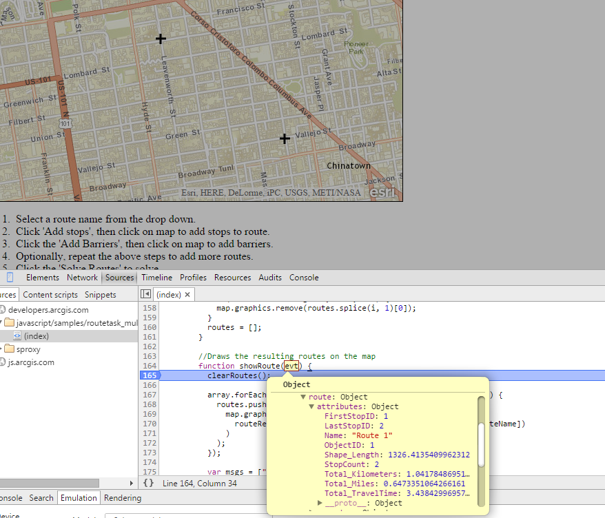
Instead of the user clicking to points on the map, you can just feed it your points. As you can see in the screenshot, the route result will include drive length/time.
Hope this helps!
Tim
- Mark as New
- Bookmark
- Subscribe
- Mute
- Subscribe to RSS Feed
- Permalink
- Report Inappropriate Content
Lucas,
Is it supposed to give you a route between the markers, like driving directions? If so, you might want to look into this
directions-amd | API Reference | ArcGIS API for JavaScript
Tim
- Mark as New
- Bookmark
- Subscribe
- Mute
- Subscribe to RSS Feed
- Permalink
- Report Inappropriate Content
Hello again Tim.
We are just hoping to show the distance from where the person fired an event in comparison to the location where he should be. So we don't really need directions, just the distance measurements...
- Mark as New
- Bookmark
- Subscribe
- Mute
- Subscribe to RSS Feed
- Permalink
- Report Inappropriate Content
- var lengths = geodesicUtils.geodesicLengths([singlePathPolyline], Units.KILOMETERS);
- console.log(lengths);
This should have returned the total length of your line. Did it not work? I think I might have a hard time understanding what you actually want to show.
- Mark as New
- Bookmark
- Subscribe
- Mute
- Subscribe to RSS Feed
- Permalink
- Report Inappropriate Content
Tim, we would like to display the driving time to the point, not the directions...
Going back to the snippet I provided, we get the following error: Uncaught TypeError: object is not a function
- Mark as New
- Bookmark
- Subscribe
- Mute
- Subscribe to RSS Feed
- Permalink
- Report Inappropriate Content
Lucas,
if you have a hosted route task, you can do something like this:
Find routes with barriers and multiple stops | ArcGIS API for JavaScript
Instead of the user clicking to points on the map, you can just feed it your points. As you can see in the screenshot, the route result will include drive length/time.
Hope this helps!
Tim
- Mark as New
- Bookmark
- Subscribe
- Mute
- Subscribe to RSS Feed
- Permalink
- Report Inappropriate Content
Good morning, I need to calculate the distance between 32000 polygons and memory error occurs during parsing. My computer has 8 gig of memory and a good processor that is not fully used during the analysis. I tried to use only 200 polygons in the analysis and the arcgis calculated normally. What is the limit on the number of polygons for the analysis of distance?