- Home
- :
- All Communities
- :
- Developers
- :
- JavaScript Maps SDK
- :
- JavaScript Maps SDK Questions
- :
- Zoom doesn't work
- Subscribe to RSS Feed
- Mark Topic as New
- Mark Topic as Read
- Float this Topic for Current User
- Bookmark
- Subscribe
- Mute
- Printer Friendly Page
- Mark as New
- Bookmark
- Subscribe
- Mute
- Subscribe to RSS Feed
- Permalink
- Report Inappropriate Content
I don't understand how there have been no complaints about zooming in the javascript api. You can take any tiled sample. Draw a box around an area you want to zoom to (shift + mouse move). It will either go too far or not far enough. How hard is it to find the extent of the box and zoom to those coordinates???
I am in IE 10.
You can use as an example Home Extent . And pick any state and draw a box to zoom in. It will not honor your box coordinates. What gives?
How can I specify coordinates or a box and have the tiled service actually zoom to that exact area?
Solved! Go to Solution.
Accepted Solutions
- Mark as New
- Bookmark
- Subscribe
- Mute
- Subscribe to RSS Feed
- Permalink
- Report Inappropriate Content
Tiled map service have predefined LODs (Levels of Display) that the map service is cached at and the zoom function will always go to the nearest LOD for that map service. If you do not like this than you can take the performance hit and use Dynamic map services instead.
- Mark as New
- Bookmark
- Subscribe
- Mute
- Subscribe to RSS Feed
- Permalink
- Report Inappropriate Content
You're kidding right? Other API's don't force a Level of Display (Silverlight for example).
- Mark as New
- Bookmark
- Subscribe
- Mute
- Subscribe to RSS Feed
- Permalink
- Report Inappropriate Content
So how would someone - say - zoom to a parcel when there is a tiled service (aerial photo) in the background?
- Mark as New
- Bookmark
- Subscribe
- Mute
- Subscribe to RSS Feed
- Permalink
- Report Inappropriate Content
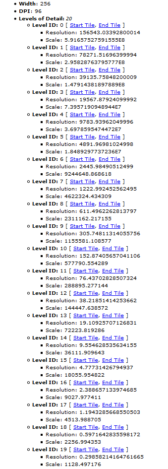
With tiled map services, the map will only show at specific scales. The image below show the levels of detail of the World Topographic Map service. When you attempt to zoom to an exact shape, the map will almost certain not be able to zoom to that scale. Instead, it has to zoom to the closest available scale.
If you were working with dynamic map services instead, you would be able to zoom to an exact shape.
- Mark as New
- Bookmark
- Subscribe
- Mute
- Subscribe to RSS Feed
- Permalink
- Report Inappropriate Content
With tiled map services, the map will only show at specific scales.
And you guys are happy with that? I didn't know I was so spoiled not having to work with the javascript API. How do you reliably zoom to a parcel?
- Mark as New
- Bookmark
- Subscribe
- Mute
- Subscribe to RSS Feed
- Permalink
- Report Inappropriate Content
You add more LODs if the parcel is small and the Tiled Map Service does not zoom in far enough, or you use dynamic map services instead (as we have both mentioned). It is really not a big issue, other APIs like Flex did the same thing.
- Mark as New
- Bookmark
- Subscribe
- Mute
- Subscribe to RSS Feed
- Permalink
- Report Inappropriate Content
Before making the switch to JavaScript, I wrote Flex applications. I was used to that behavior and was surprised to see that Silverlight doesn't do it like that.
For zooming into a specific objects (like a parcel), I include the fit Boolean in the setExtent method to make sure the object is completely inside the new extent
map.setExtent(objectExtent, true);
- Mark as New
- Bookmark
- Subscribe
- Mute
- Subscribe to RSS Feed
- Permalink
- Report Inappropriate Content
If you don't like this, just wait until you discover that not all of the base maps that ESRI offers let you zoom in the same amount!
I also came from FLEX, so from my perspective, having only specific scales available to you based on tiles is normal. I see it more as a limitation of using a tiled service, not as a restriction of the API itself.
- Mark as New
- Bookmark
- Subscribe
- Mute
- Subscribe to RSS Feed
- Permalink
- Report Inappropriate Content
Well, thanks for your comments, anyway. I suppose I shouldn't be surprised. ESRI has never been known for being consistent across platforms.
I guess it goes to show that you don't complain about things you don't have that you never knew were possible. And you take for granted things that you use everyday that you didn't know were not possible in other places.
I didn't realize four years ago when I was designing layers for my Silverlight app how critical my tiling structure choices should have been.