- Home
- :
- All Communities
- :
- User Groups
- :
- Coordinate Reference Systems
- :
- Questions
- :
- SAD69 to SIRGAS2000 reprojection
- Subscribe to RSS Feed
- Mark Topic as New
- Mark Topic as Read
- Float this Topic for Current User
- Bookmark
- Subscribe
- Mute
- Printer Friendly Page
- Mark as New
- Bookmark
- Subscribe
- Mute
- Subscribe to RSS Feed
- Permalink
- Report Inappropriate Content
What should I be aware of before trying to reproject a SAD69 feature class to SIRGAS2000? What are the steps needed to accomplish this task?
I found this link that points to a program called ProGriD developed by IBGE (the brazilian institute of geography and statistic).
Instead of using a third-party software I would like to do it in ArcMap, because in ArcMap I can create a python script to run against all feature classes at once and store the reprojected data in a brand new database instead of modifying the old one.
*Note:I 'm not familiar with reprojections. I'm a developer, not a geographer.
Solved! Go to Solution.
Accepted Solutions
- Mark as New
- Bookmark
- Subscribe
- Mute
- Subscribe to RSS Feed
- Permalink
- Report Inappropriate Content
For those facing the same problem,
I've created a Custom Geographic Transformation from SAD69 to SIRGAS2000 using the geodesic transformation parameters provided by IBGE (the brazilian institute of gegraphy and statistic):∆X = − 67,35 m ∆Y = + 3,88 m ∆Z = − 38,22 m.
These parameters are the official ones since 2005, when the SGB (Brazilian Geodesic System) was updated. Here is the link to the source document
I couldn't find the transformation information at the EPSG-Registry.org so I didn't test it.
But after our client compared the results of ArcMap default transformation and the custom one, he opted by the custom one that was made using IBGE parameters.
- Mark as New
- Bookmark
- Subscribe
- Mute
- Subscribe to RSS Feed
- Permalink
- Report Inappropriate Content
Take a look at: ArcGIS Help - Project (Data Management) for the re-projection of features in ArcGIS.
The output should ideally be compared to similar known features which are already in the output coordinate system to see if they line up.
- Mark as New
- Bookmark
- Subscribe
- Mute
- Subscribe to RSS Feed
- Permalink
- Report Inappropriate Content
I will try to use that tool and then post the results here. Thanks.
- Mark as New
- Bookmark
- Subscribe
- Mute
- Subscribe to RSS Feed
- Permalink
- Report Inappropriate Content
You may also want to take a look at the EPSG Geodetic Parameter Registry. Many transformations that we support come from it. They list several transformations that are appropriate for different areas, and also list a 1996 re-adjustment of SAD 1969, with associated transformations. We should support most, if not all of them, depending on which version you're using.
Melita
Disclosure: I'm on the subcommittee that maintains the EPSG registry.
- Mark as New
- Bookmark
- Subscribe
- Mute
- Subscribe to RSS Feed
- Permalink
- Report Inappropriate Content
I didn't find transformation information at the registry, just this: http://www.epsg-registry.org/report.htm?type=selection&entity=urn:ogc:def:crs:EPSG::4618&reportDetai...
Can you guide me step by step to find SAD69 to SIRGAS2000 parameters?
- Mark as New
- Bookmark
- Subscribe
- Mute
- Subscribe to RSS Feed
- Permalink
- Report Inappropriate Content
Using the online registry, you could set up search this way:
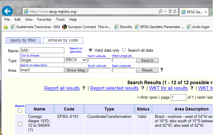
The query by filter tab is selected, and I've entered SAD (which is automatically a wildcard search) in the Name field. For the Type, click it and select Coordinate Transformation - Single. In Area, I also entered Brazil. That will return any relevant transformations. There are actually 4 that use those parameter values.
15485 SAD 1969 to SIRGAS 2000 (1)
5882 SAD 1969 to WGS 1984 (16)
5881 SAD 1969 (96) to SIRGAS 2000 (2)
6195 SAD 1969 (96) to WGS 1984 (2)
but they might not be available in the version you're using. They're definitely there in 10.3.
Another way to check the EPSG registry which might be easier, and definitely is if you're trying to search on a parameter value, is to download the Access database version. It's released twice a year, so may not be up-to-date with the registry, but you can get to the underlaying tables and do searches on fields. It's available at http://www.epsg.org. You may have to register to access it, but there's no cost, and your information isn't used elsewhere.
Melita
- Mark as New
- Bookmark
- Subscribe
- Mute
- Subscribe to RSS Feed
- Permalink
- Report Inappropriate Content
Thank you Melita.
- Mark as New
- Bookmark
- Subscribe
- Mute
- Subscribe to RSS Feed
- Permalink
- Report Inappropriate Content
For those facing the same problem,
I've created a Custom Geographic Transformation from SAD69 to SIRGAS2000 using the geodesic transformation parameters provided by IBGE (the brazilian institute of gegraphy and statistic):∆X = − 67,35 m ∆Y = + 3,88 m ∆Z = − 38,22 m.
These parameters are the official ones since 2005, when the SGB (Brazilian Geodesic System) was updated. Here is the link to the source document
I couldn't find the transformation information at the EPSG-Registry.org so I didn't test it.
But after our client compared the results of ArcMap default transformation and the custom one, he opted by the custom one that was made using IBGE parameters.