- Home
- :
- All Communities
- :
- Products
- :
- ArcGIS Spatial Analyst
- :
- ArcGIS Spatial Analyst Questions
- :
- Spatial Analyst - 3D Polyline from Point Data
- Subscribe to RSS Feed
- Mark Topic as New
- Mark Topic as Read
- Float this Topic for Current User
- Bookmark
- Subscribe
- Mute
- Printer Friendly Page
Spatial Analyst - 3D Polyline from Point Data
- Mark as New
- Bookmark
- Subscribe
- Mute
- Subscribe to RSS Feed
- Permalink
- Report Inappropriate Content
I have surveyed cross sections of the bathymetry of a creek. The data is in the form of points. I have a hold of a tool that will create a DEM of the creek bathymetry, but the input it needs for the cross section data is 3d polylines. I cannot find a tool that will allow me to create 3D polylines from my point data. Help please!
Or, does anybody know of a good way to create a DEM of the creek bathymetry straight from the points?
- Jeff
ArcMap 10.1 Desktop Basic License
Spatial Analyst extension
3D Analyst extension
- Mark as New
- Bookmark
- Subscribe
- Mute
- Subscribe to RSS Feed
- Permalink
- Report Inappropriate Content
You can interpolate your points to a surface using one of many tools available: ArcGIS Help 10.1
- Mark as New
- Bookmark
- Subscribe
- Mute
- Subscribe to RSS Feed
- Permalink
- Report Inappropriate Content
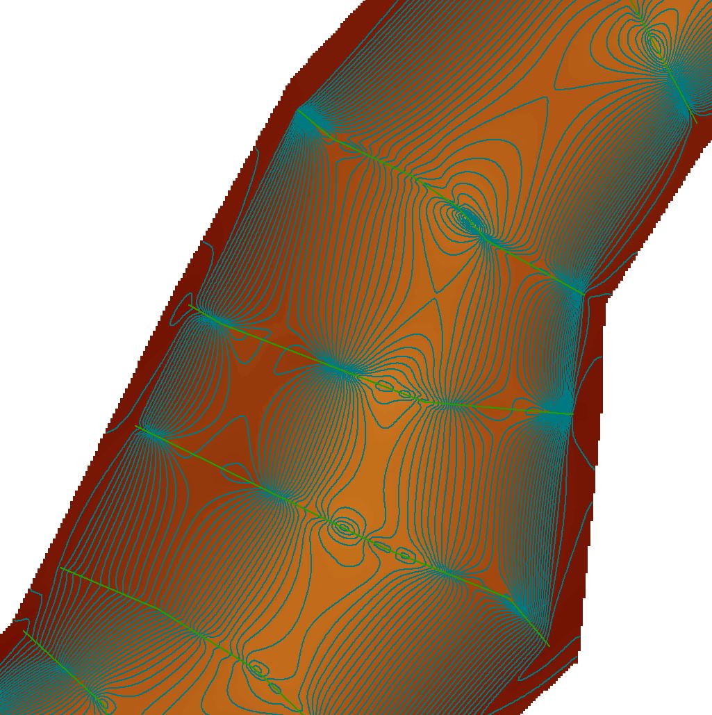
I tried using the various interpolation tools, and the results were not what I am looking for. The interpolation tools to not "know" that the creek must continuously flow downhill. This screenshot of a small portion demonstrates what I mean. The yellow is lower elevation, and the red is higher elevation. The interpolation tool (this one was Natural Neighbor) does not recognize that there is a channel present with surrounding floodplain. Right now the interpolation tools show that the bottom of the channel is deepest where I have cross section data, and then as soon as no real data in present, the channel bottom rises. Hopefully what I am trying to describe makes sense.
- Jeff
- Mark as New
- Bookmark
- Subscribe
- Mute
- Subscribe to RSS Feed
- Permalink
- Report Inappropriate Content
To hopefully make a little more clear what I am dealing with, in the attached image, I have spot elevation data long the green cross section lines. I used natural neighbor interpolation to create the yellow/orange/red raster DEM. I then contoured this DEM to 1 foot intervals. From the screenshot, it is apparent that the interpolation method (while not incorrect in its mathematical definition) for my creek/floodplain, interpolated incorrectly. Does anybody have a suggestion as to how to take the given point data along the cross section lines, and create a realistic creek/floodplain DEM?
Again, this is a small portion of the creek I am showing. I have about 150 cross sections in total, so manually manipulating the contours would be a daunting task.
Thanks for any/all help!
-Jeff
- Mark as New
- Bookmark
- Subscribe
- Mute
- Subscribe to RSS Feed
- Permalink
- Report Inappropriate Content
Have you tried using the Topo to Raster interpolation tool and include a stream layer to help the interpolation?
- Mark as New
- Bookmark
- Subscribe
- Mute
- Subscribe to RSS Feed
- Permalink
- Report Inappropriate Content
I tried that tool the other day, and the result was basically no different than the screenshot I showed of the natural neighbor interpolation. Perhaps because my stream centerline feature is a 2D polyline with no elevations? I will try this tool again after digitizing the stream centerline as a 3D polyline with elevations.
- Jeff
- Mark as New
- Bookmark
- Subscribe
- Mute
- Subscribe to RSS Feed
- Permalink
- Report Inappropriate Content
Hi Jeff,
I don't think this method or any of the interpolation methods available in ArcGIS, will give you the result you are anticipating. This type of interpolation requires specialized software. You mentioned you have access to such a tool, but require 3D polylines as input. If you are willing to provide a sample of your input data, I can have a look at it and write some python script to create the 3D polylines.
If that tool doesn't work, I would probably create some code to use the centerline of the river and the borders of the river itself to create parallel lines following the river and cross those with the depth information to create 3D lines following the river and use those for the interpolation (through a TIN).
While I write this, I would say that you are not the first person to confront this type of problem. I'll give my friend (the Internet) a visit and get back to you if I find something useful...
Kind regards, Xander
- Mark as New
- Bookmark
- Subscribe
- Mute
- Subscribe to RSS Feed
- Permalink
- Report Inappropriate Content
Well I tried to Topo to Raster Interpolation, using the defined stream, and it gave me better results, but still not exactly what I am looking for.
The tool I have access to was downloaded from a PhD at Purdue, at: Dr. Venkatesh Merwade's web page . I have not actually used it, just ran though his tutorial, and it seemed to give the results I was looking for. I am struggling with getting my data into the format needed to use his tool.
I am not sure if I am able to send you my data (permissions and such...). I will get back to you ASAP with it if I am allowed to!
You mention "specialized software", are there any programs out there that you know of that do this? I anticipate needing to achieve these results from similar datasets a lot in my future, and having another software tool to make it easier/faster would be awesome.
I appreciate you (and everyone else!) for taking the time to reply to my post. I am continuing to work on this, and more feedback is always welcome!
- Jeff
- Mark as New
- Bookmark
- Subscribe
- Mute
- Subscribe to RSS Feed
- Permalink
- Report Inappropriate Content
Hi Jeff,
The link below has a nice discussion on the topic and also lists some (commercial) software:
I have worked on some projects for the Dutch Ministry of Transport, Public Works and Water Management and a specialist developed his own interpolation for in house use. Quite an interesting job he did. And like that there will be many more examples.
Don't worry about sending original data. As long as the structure is the same, you can send some dummy data. The idea is to have something to program against.
Kind regards, Xander
- Mark as New
- Bookmark
- Subscribe
- Mute
- Subscribe to RSS Feed
- Permalink
- Report Inappropriate Content
Have you tried making a TIN from the points? If you have shorelines, use those as hard break lines so the TIN does not "take short cuts.