- Home
- :
- All Communities
- :
- Developers
- :
- JavaScript Maps SDK
- :
- JavaScript Maps SDK Questions
- :
- Open Info Window on grid RowClick
- Subscribe to RSS Feed
- Mark Topic as New
- Mark Topic as Read
- Float this Topic for Current User
- Bookmark
- Subscribe
- Mute
- Printer Friendly Page
Open Info Window on grid RowClick
- Mark as New
- Bookmark
- Subscribe
- Mute
- Subscribe to RSS Feed
- Permalink
- Report Inappropriate Content
I have the code below that shows the info window on map click. I would like to call the same function in the gridRowClick event.
function identifyPOI(evt) {


    var measureMode = dojo.query(".esriButton .dijitButtonNode").some(function (node, index, arr) {
        if (node.childNodes[0].checked) {
            //at least one of the measure tools is active so disable identify
            return true;


        }
    });


    if (!measureMode) {


        var identify = new esri.tasks.IdentifyTask(".../MapServer");
        var identifyParams = new esri.tasks.IdentifyParameters();
        identifyParams.geometry = evt.mapPoint;
        identifyParams.mapExtent = map.extent;
        identifyParams.returnGeometry = true;
        identifyParams.tolerance = 3;


        map.infoWindow.clearFeatures();

        //Define a good infoTemplate
        var infoTemplateUtilities = new esri.InfoTemplate();

        infoTemplateUtilities.setTitle("FacilityID: <br/> <b>${Facility Identifier}</b>");
        infoTemplateUtilities.setContent("Open file:  <b> <a href='Documentation/${MAPREF}.pdf' target='_blank'> ${MAPREF} </a>  </b><br/>" +
                                  "Install Date: <b>${Install Date} </b><br/>" +
                                  "Material: <b>${Material}</b><br/>" +
                                  "Diameter: <b>${Diameter}</b> <br/>" +
                                  "Status: <b>${Status}</b> <br/>" +
                                  "Last Update Date: <b>${Last Update Date}</b> <br/>" +
                                  "Water Type: <b>${Water Type}</b> <br/>" +
                                  "Lenght(ft): <b>${SHAPE_Length}</b> <br/>");


        try {
            identify.execute(identifyParams, function (results) {


                map.infoWindow.setFeatures(dojo.map(results, function (result) {
                    var feature = result.feature;
                    feature.setInfoTemplate(infoTemplateUtilities);
                    return feature;
                }));
                map.infoWindow.show(evt.mapPoint);
            });


        }
        catch (ex) {
            alert(ex.toString());
        }

    }

};


function onRowClickHandler(evt) {
    var clickedUtilityId = grid.getItem(evt.rowIndex).OBJECTID;


    var selectedUtility;

    dojo.forEach(map.graphics.graphics, function (graphic) {
        if ((graphic.attributes) && graphic.attributes.OBJECTID === clickedUtilityId) {
            selectedUtility = graphic.geometry;
            return;
        }
    });


    var thePoly = selectedUtility;
    var theExtent = thePoly.getExtent();
    map.setExtent(theExtent, true);


    //and display the infoWindow
    var utilityLenght = thePoly.paths[0].length;
    if(utilityLenght % 2 !=0){
       utilityLenght = utilityLenght - 1;


       var pointXY = thePoly.paths[0][(utilityLenght / 2)];


       var infoPoint = new esri.geometry.Point(pointXY[0], pointXY[1], new esri.spatialReference({ wkid: 102723 }));


       try{

           identifyPOI(evt.infoPoint); //<====  here is where I am not sure...
        }
       catch (ex) {
           alert(ex.toString());
       }


    }

};
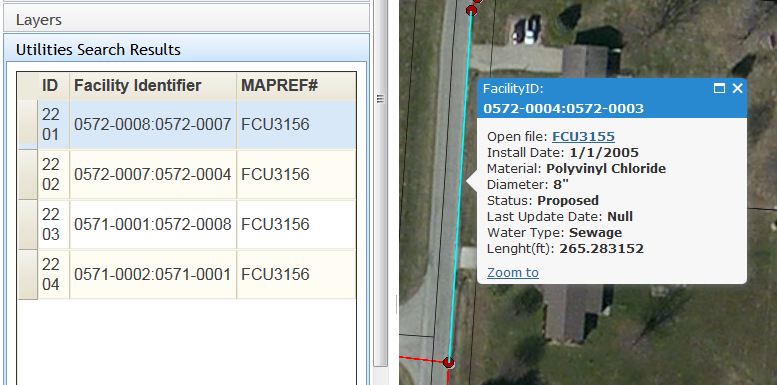
the image below is the final result I am trying to achieve.
- Mark as New
- Bookmark
- Subscribe
- Mute
- Subscribe to RSS Feed
- Permalink
- Report Inappropriate Content
I think the simplest thing to do would be to rewrite your identifyPOI function so it takes a point instead of an event, since you don't use any other part of the event.
.
function identifyPOI(point) {
You'll just have to make sure you pass in the point on the map click. If that isn't possible, you could do something like this
function identifyPOI(evt) {


    openInfoWindow(evt.mapPoint);


}


function openInfoWindow(point) {


    var measureMode = dojo.query(".esriButton .dijitButtonNode").some(function (node, index, arr) {


        if (node.childNodes[0].checked) {


            //at least one of the measure tools is active so disable identify


            return true;


        }


    });


    if (!measureMode) {


        var identify = new esri.tasks.IdentifyTask(".../MapServer");


        var identifyParams = new esri.tasks.IdentifyParameters();


        identifyParams.geometry = evt.mapPoint;


        identifyParams.mapExtent = map.extent;


        identifyParams.returnGeometry = true;


        identifyParams.tolerance = 3;


        map.infoWindow.clearFeatures();


        //Define a good infoTemplate


        var infoTemplateUtilities = new esri.InfoTemplate();


        infoTemplateUtilities.setTitle("FacilityID: <br/> <b>${Facility Identifier}</b>");


        infoTemplateUtilities.setContent("Open file:  <b> <a href='Documentation/${MAPREF}.pdf' target='_blank'> ${MAPREF} </a>  </b><br/>" +


                                  "Install Date: <b>${Install Date} </b><br/>" +


                                  "Material: <b>${Material}</b><br/>" +


                                  "Diameter: <b>${Diameter}</b> <br/>" +


                                  "Status: <b>${Status}</b> <br/>" +


                                  "Last Update Date: <b>${Last Update Date}</b> <br/>" +


                                  "Water Type: <b>${Water Type}</b> <br/>" +


                                  "Lenght(ft): <b>${SHAPE_Length}</b> <br/>");


        try {


            identify.execute(identifyParams, function (results) {


                map.infoWindow.setFeatures(dojo.map(results, function (result) {


                    var feature = result.feature;


                    feature.setInfoTemplate(infoTemplateUtilities);


                    return feature;


                }));


                map.infoWindow.show(point);


            });


        }


        catch (ex) {


            alert(ex.toString());


        }


    }


}
and inf the onRowClickHandler function, use
- try{
- openInfoWindow(infoPoint); //<==== here is where I am not sure...
- }
- catch (ex) {
- alert(ex.toString());
- }
- Mark as New
- Bookmark
- Subscribe
- Mute
- Subscribe to RSS Feed
- Permalink
- Report Inappropriate Content
Thank you Ken for replying...
I tried what you said and it did not work. I also tried to change
identifyParams.geometry = point; line 16 above
but still nothing.
- Mark as New
- Bookmark
- Subscribe
- Mute
- Subscribe to RSS Feed
- Permalink
- Report Inappropriate Content
Did you get this figured out yet? It seems like a post that even a week old gets lost down the list.