Turn on suggestions
Auto-suggest helps you quickly narrow down your search results by suggesting possible matches as you type.
Cancel
- Home
- :
- All Communities
- :
- Developers
- :
- ArcObjects SDK
- :
- ArcObjects SDK Questions
- :
- Polyline forming closed segment
Options
- Subscribe to RSS Feed
- Mark Topic as New
- Mark Topic as Read
- Float this Topic for Current User
- Bookmark
- Subscribe
- Mute
- Printer Friendly Page
by
Anonymous User
Not applicable
10-08-2013
08:21 PM
- Mark as New
- Bookmark
- Subscribe
- Mute
- Subscribe to RSS Feed
- Permalink
- Report Inappropriate Content
Original User: e_saurabh
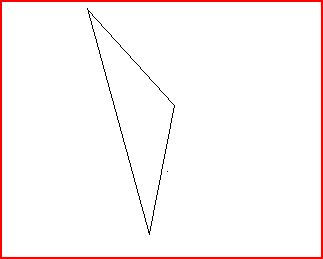
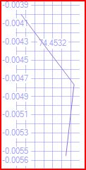
[ATTACH=CONFIG]28156[/ATTACH][ATTACH=CONFIG]28157[/ATTACH]
Hi,
We are facing a real complex issue regarding creating the Polyline from the coordinate values.
The issue is regarding polyline geometry, when we get the coordinates of the SQL Geometry and trying to create ARCGIS Geometry using PointCollection and Polyline class of IPointCollection and IGeometry interfaces through AddPointCollection method, the last and first vertices of the polyline geometry is getting joined automatically and forms a line segment and creates a shape like polygon and then pushes this to ArcSDE. This happens for simple and complex polylines. Attached is the actual polyline in the SQl Server geometry and the polyline which forms a close segment in ArcSDE GDB. We are using SQl Server 2008, ArcGIS Server 10.0 and ArcSDE 10.0. Attached are the images.
This has become a show stopper for our application. If anyone can please respond quickly on this.
Regards,
Saurabh.
Solved! Go to Solution.
1 Solution
Accepted Solutions
10-09-2013
06:37 AM
- Mark as New
- Bookmark
- Subscribe
- Mute
- Subscribe to RSS Feed
- Permalink
- Report Inappropriate Content
Here you are creating a new polyline:
polyline = (Polyline)serverContext.CreateObject("esriGeometry.Polyline");
Here you are performing a QI from IPoint to IPointCollection:
pointCollection = polyline as IPointCollection;
Here you are adding points to the point collection:
for (int count = 0; count < geoDataArray.Length; count++)
{
pointArray = geoDataArray[count].Split(new char[] { ',' });
latitude = Convert.ToDouble(pointArray[0].ToString());
longitude = Convert.ToDouble(pointArray[1].ToString());
point.X = latitude;
point.Y = longitude;
pointCollection.AddPoint(point, ref missingObject, ref missingObject);
}
At this point you have created the polyline and added the points.
But, here you add the points again by adding the point collection to the polyline:
polyline.AddPointCollection(pointCollection);
You don't want to do that because you're adding the points twice.
6 Replies
10-09-2013
04:54 AM
- Mark as New
- Bookmark
- Subscribe
- Mute
- Subscribe to RSS Feed
- Permalink
- Report Inappropriate Content
without the actual code fragment it is very difficult to help.
by
Anonymous User
Not applicable
10-09-2013
06:08 AM
- Mark as New
- Bookmark
- Subscribe
- Mute
- Subscribe to RSS Feed
- Permalink
- Report Inappropriate Content
Original User: e_saurabh
Please find the code below...
IFeature feature = featureClass.CreateFeature();
IGeometry lineGeometry;
Polyline polyline;
string shapeGeoData = string.Empty;
IPointCollection pointCollection;
shapeGeoData = geoData.Remove(0, 10);
shapeGeoData = shapeGeoData.Replace("(", "");
shapeGeoData = shapeGeoData.Replace(")", "");
shapeGeoData = shapeGeoData.Replace(", ", ",");
shapeGeoData = shapeGeoData.Replace(" ", ";");
shapeGeoData = shapeGeoData.Replace(",", " ");
shapeGeoData = shapeGeoData.Replace(";", ",");
shapeGeoData = shapeGeoData.TrimStart(',');
polyline = (Polyline)serverContext.CreateObject("esriGeometry.Polyline");
pointCollection = polyline as IPointCollection;
string value = shapeGeoData
string[] geoDataArray = value.Split(new char[] { ' ' });
IPoint point = (IPoint)serverContext.CreateObject("esriGeometry.Point");
object missingObject = Type.Missing;
for (int count = 0; count < geoDataArray.Length; count++)
{
pointArray = geoDataArray[count].Split(new char[] { ',' });
latitude = Convert.ToDouble(pointArray[0].ToString());
longitude = Convert.ToDouble(pointArray[1].ToString());
point.X = latitude;
point.Y = longitude;
pointCollection.AddPoint(point, ref missingObject, ref missingObject);
}
polyline.AddPointCollection(pointCollection);
ISpatialReferenceFactory spatialReferenceFactory;
ISpatialReferenceResolution spatialReferenceResolution;
ISpatialReferenceTolerance spatialReferenceTolerance;
ISpatialReference spatialReference=null;
SpatialReferenceFactory = serverContext.CreateObject("esriGeometry.SpatialReferenceEnvironment") as ISpatialReferenceFactory;
//Create a projected coordinate system and define its domain, resolution, and x,y tolerance.
spatialReferenceResolution = spatialReferenceFactory.CreateGeographicCoordinateSystem(SRID) as ISpatialReferenceResolution;
spatialReferenceResolution.ConstructFromHorizon();
spatialReferenceTolerance = spatialReferenceResolution as ISpatialReferenceTolerance;
spatialReferenceTolerance.SetDefaultXYTolerance();
spatialReference = spatialReferenceResolution as ISpatialReference;
lineGeometry.SpatialReference = spatialReference
ITopologicalOperator topologicalOperator = polyline as ITopologicalOperator;
topologicalOperator.Simplify();
feature.Shape = lineGeometry;
feature.Store();
without the actual code fragment it is very difficult to help.
Please find the code below...
IFeature feature = featureClass.CreateFeature();
IGeometry lineGeometry;
Polyline polyline;
string shapeGeoData = string.Empty;
IPointCollection pointCollection;
shapeGeoData = geoData.Remove(0, 10);
shapeGeoData = shapeGeoData.Replace("(", "");
shapeGeoData = shapeGeoData.Replace(")", "");
shapeGeoData = shapeGeoData.Replace(", ", ",");
shapeGeoData = shapeGeoData.Replace(" ", ";");
shapeGeoData = shapeGeoData.Replace(",", " ");
shapeGeoData = shapeGeoData.Replace(";", ",");
shapeGeoData = shapeGeoData.TrimStart(',');
polyline = (Polyline)serverContext.CreateObject("esriGeometry.Polyline");
pointCollection = polyline as IPointCollection;
string value = shapeGeoData
string[] geoDataArray = value.Split(new char[] { ' ' });
IPoint point = (IPoint)serverContext.CreateObject("esriGeometry.Point");
object missingObject = Type.Missing;
for (int count = 0; count < geoDataArray.Length; count++)
{
pointArray = geoDataArray[count].Split(new char[] { ',' });
latitude = Convert.ToDouble(pointArray[0].ToString());
longitude = Convert.ToDouble(pointArray[1].ToString());
point.X = latitude;
point.Y = longitude;
pointCollection.AddPoint(point, ref missingObject, ref missingObject);
}
polyline.AddPointCollection(pointCollection);
ISpatialReferenceFactory spatialReferenceFactory;
ISpatialReferenceResolution spatialReferenceResolution;
ISpatialReferenceTolerance spatialReferenceTolerance;
ISpatialReference spatialReference=null;
SpatialReferenceFactory = serverContext.CreateObject("esriGeometry.SpatialReferenceEnvironment") as ISpatialReferenceFactory;
//Create a projected coordinate system and define its domain, resolution, and x,y tolerance.
spatialReferenceResolution = spatialReferenceFactory.CreateGeographicCoordinateSystem(SRID) as ISpatialReferenceResolution;
spatialReferenceResolution.ConstructFromHorizon();
spatialReferenceTolerance = spatialReferenceResolution as ISpatialReferenceTolerance;
spatialReferenceTolerance.SetDefaultXYTolerance();
spatialReference = spatialReferenceResolution as ISpatialReference;
lineGeometry.SpatialReference = spatialReference
ITopologicalOperator topologicalOperator = polyline as ITopologicalOperator;
topologicalOperator.Simplify();
feature.Shape = lineGeometry;
feature.Store();
10-09-2013
06:37 AM
- Mark as New
- Bookmark
- Subscribe
- Mute
- Subscribe to RSS Feed
- Permalink
- Report Inappropriate Content
Here you are creating a new polyline:
polyline = (Polyline)serverContext.CreateObject("esriGeometry.Polyline");
Here you are performing a QI from IPoint to IPointCollection:
pointCollection = polyline as IPointCollection;
Here you are adding points to the point collection:
for (int count = 0; count < geoDataArray.Length; count++)
{
pointArray = geoDataArray[count].Split(new char[] { ',' });
latitude = Convert.ToDouble(pointArray[0].ToString());
longitude = Convert.ToDouble(pointArray[1].ToString());
point.X = latitude;
point.Y = longitude;
pointCollection.AddPoint(point, ref missingObject, ref missingObject);
}
At this point you have created the polyline and added the points.
But, here you add the points again by adding the point collection to the polyline:
polyline.AddPointCollection(pointCollection);
You don't want to do that because you're adding the points twice.
polyline = (Polyline)serverContext.CreateObject("esriGeometry.Polyline");
Here you are performing a QI from IPoint to IPointCollection:
pointCollection = polyline as IPointCollection;
Here you are adding points to the point collection:
for (int count = 0; count < geoDataArray.Length; count++)
{
pointArray = geoDataArray[count].Split(new char[] { ',' });
latitude = Convert.ToDouble(pointArray[0].ToString());
longitude = Convert.ToDouble(pointArray[1].ToString());
point.X = latitude;
point.Y = longitude;
pointCollection.AddPoint(point, ref missingObject, ref missingObject);
}
At this point you have created the polyline and added the points.
But, here you add the points again by adding the point collection to the polyline:
polyline.AddPointCollection(pointCollection);
You don't want to do that because you're adding the points twice.
by
Anonymous User
Not applicable
10-09-2013
12:40 PM
- Mark as New
- Bookmark
- Subscribe
- Mute
- Subscribe to RSS Feed
- Permalink
- Report Inappropriate Content
Original User: e_saurabh
Hi Neil,
Thanks a lot!! Your click worked right away. Now this works fine. Probably some coding mistakes.
Regards,
Saurabh.
Here you are creating a new polyline:
polyline = (Polyline)serverContext.CreateObject("esriGeometry.Polyline");
Here you are performing a QI from IPoint to IPointCollection:
pointCollection = polyline as IPointCollection;
Here you are adding points to the point collection:
for (int count = 0; count < geoDataArray.Length; count++)
{
pointArray = geoDataArray[count].Split(new char[] { ',' });
latitude = Convert.ToDouble(pointArray[0].ToString());
longitude = Convert.ToDouble(pointArray[1].ToString());
point.X = latitude;
point.Y = longitude;
pointCollection.AddPoint(point, ref missingObject, ref missingObject);
}
At this point you have created the polyline and added the points.
But, here you add the points again by adding the point collection to the polyline:
polyline.AddPointCollection(pointCollection);
You don't want to do that because you're adding the points twice.
Hi Neil,
Thanks a lot!! Your click worked right away. Now this works fine. Probably some coding mistakes.
Regards,
Saurabh.
by
Anonymous User
Not applicable
10-09-2013
03:28 PM
- Mark as New
- Bookmark
- Subscribe
- Mute
- Subscribe to RSS Feed
- Permalink
- Report Inappropriate Content
You may also want to check or change:
point.X = latitude; point.Y = longitude;
by
Anonymous User
Not applicable
10-10-2013
05:45 AM
- Mark as New
- Bookmark
- Subscribe
- Mute
- Subscribe to RSS Feed
- Permalink
- Report Inappropriate Content
Original User: e_saurabh
Sure Sean.. will follow up a check on this. Thanks.
Regards,
Saurabh.
Sure Sean.. will follow up a check on this. Thanks.
Regards,
Saurabh.