Turn on suggestions
Auto-suggest helps you quickly narrow down your search results by suggesting possible matches as you type.
Cancel
- Home
- :
- All Communities
- :
- Products
- :
- Data Management
- :
- Data Management Questions
- :
- Error: ???two donuts or two outer shells overlap??...
Options
- Subscribe to RSS Feed
- Mark Topic as New
- Mark Topic as Read
- Float this Topic for Current User
- Bookmark
- Subscribe
- Mute
- Printer Friendly Page
Error: ???two donuts or two outer shells overlap???,
Subscribe
4076
31
04-24-2014 04:02 AM
by
Anonymous User
Not applicable
04-24-2014
04:02 AM
- Mark as New
- Bookmark
- Subscribe
- Mute
- Subscribe to RSS Feed
- Permalink
- Report Inappropriate Content
Original User: Jamal432@gmail.com
Error: �??two donuts or two outer shells overlap�?�,
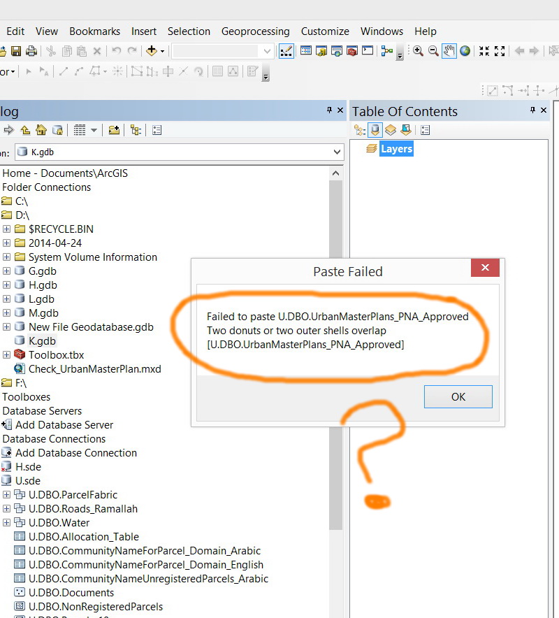
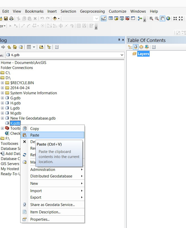
I wanted to copy enterprise geodatabase layer to file geodatabase but I got the error below (�??two donuts or two outer shells overlap�?�):
[ATTACH=CONFIG]33329[/ATTACH], [ATTACH=CONFIG]33330[/ATTACH], [ATTACH=CONFIG]33331[/ATTACH]
What might be the issue here?
Thank you
Best
Jamal
Error: �??two donuts or two outer shells overlap�?�,
I wanted to copy enterprise geodatabase layer to file geodatabase but I got the error below (�??two donuts or two outer shells overlap�?�):
[ATTACH=CONFIG]33329[/ATTACH], [ATTACH=CONFIG]33330[/ATTACH], [ATTACH=CONFIG]33331[/ATTACH]
What might be the issue here?
Thank you
Best
Jamal
31 Replies
by
Anonymous User
Not applicable
04-24-2014
05:12 AM
- Mark as New
- Bookmark
- Subscribe
- Mute
- Subscribe to RSS Feed
- Permalink
- Report Inappropriate Content
Original User: vangelo
The issue is that two donuts or two outer shells overlap (a violation of polygon topology
restrictions).
It would help if you did some research on shape topology. I use the reference work from
which the Esri libraries were designed:
E. Clementini, P. Di Felice, and P. van Oosterom, "A Small Set of Formal Topological Relationships Suitable for End-User Interaction," in Advances in Spatial Databases - Third International Symposium, SSD '93. vol. 692, D. Abel and B. C. Ooi, Eds. Berlin: Springer-Verlag, 1993, pp. 277-295.
This will also explain what a self-intersecting simple_line boundary is (though it was the
Open GIS Consortium that named the more restrictive SIMPLE_LINE that way).
- V
PS: The older ArcSDE documentation has a primer on shape validation which should also
be useful.
04-24-2014
09:05 AM
- Mark as New
- Bookmark
- Subscribe
- Mute
- Subscribe to RSS Feed
- Permalink
- Report Inappropriate Content
The issue is that two donuts or two outer shells overlap (a violation of polygon topology
restrictions).
It would help if you did some research on shape topology. I use the reference work from
which the Esri libraries were designed:
E. Clementini, P. Di Felice, and P. van Oosterom, "A Small Set of Formal Topological Relationships Suitable for End-User Interaction," in Advances in Spatial Databases - Third International Symposium, SSD '93. vol. 692, D. Abel and B. C. Ooi, Eds. Berlin: Springer-Verlag, 1993, pp. 277-295.
This will also explain what a self-intersecting simple_line boundary is (though it was the
Open GIS Consortium that named the more restrictive SIMPLE_LINE that way).
- V
PS: The older ArcSDE documentation has a primer on shape validation which should also
be useful.
Thanks Vince,
What is confusing me the most, at this stage, is why should this be an issue. I�??m not applying any type of rules or topology. All what I do is copying and pasting.
By the way, if I IMPORT the same layer from the enterprise geodatabase to the file geodatabase, it works! Then why the issue is related to copy\paste approach? how the import does work?
----------------------------------------
Jamal Numan
Geomolg Geoportal for Spatial Information
Ramallah, West Bank, Palestine
Jamal Numan
Geomolg Geoportal for Spatial Information
Ramallah, West Bank, Palestine
by
Anonymous User
Not applicable
04-24-2014
09:48 AM
- Mark as New
- Bookmark
- Subscribe
- Mute
- Subscribe to RSS Feed
- Permalink
- Report Inappropriate Content
Original User: vangelo
Which is why you need to study the documentation on shape validation -- It does NOT
mean the same thing as applying rules to feature classes. This topology is about how
actual geometry primitives work, self-referentially. Without this understanding, you
will always be confused with respect to data conversion errors.
- V
04-24-2014
10:33 AM
- Mark as New
- Bookmark
- Subscribe
- Mute
- Subscribe to RSS Feed
- Permalink
- Report Inappropriate Content
Which is why you need to study the documentation on shape validation -- It does NOT
mean the same thing as applying rules to feature classes. This topology is about how
actual geometry primitives work, self-referentially. Without this understanding, you
will always be confused with respect to data conversion errors.
- V
That�??s for sure. Understanding will answer why But will never solve the issue.
But how IMPORT is different from COPY\PASTE? We are here talking about same features that will be copied at the end of the day to the file geodatabase? How they are accepted if they are imported but not if they are copied\pasted?
----------------------------------------
Jamal Numan
Geomolg Geoportal for Spatial Information
Ramallah, West Bank, Palestine
Jamal Numan
Geomolg Geoportal for Spatial Information
Ramallah, West Bank, Palestine
by
Anonymous User
Not applicable
04-24-2014
11:39 AM
- Mark as New
- Bookmark
- Subscribe
- Mute
- Subscribe to RSS Feed
- Permalink
- Report Inappropriate Content
Original User: vangelo
They are different processes. Export/Import runs the equivalent of Repair
Geometry on a feature if it fails on insert and tries again. If the insert fails
on the second attempt then it rejects the feature and goes on. This is both
good and bad, since invalid data that can be coaxed into something that
looks valid will pass, but then you've got garbage in your database.
- V
04-25-2014
12:22 PM
- Mark as New
- Bookmark
- Subscribe
- Mute
- Subscribe to RSS Feed
- Permalink
- Report Inappropriate Content
They are different processes. Export/Import runs the equivalent of Repair
Geometry on a feature if it fails on insert and tries again. If the insert fails
on the second attempt then it rejects the feature and goes on. This is both
good and bad, since invalid data that can be coaxed into something that
looks valid will pass, but then you've got garbage in your database.
- V
Thanks Vince for the input. This is very useful
Best
Jamal
----------------------------------------
Jamal Numan
Geomolg Geoportal for Spatial Information
Ramallah, West Bank, Palestine
Jamal Numan
Geomolg Geoportal for Spatial Information
Ramallah, West Bank, Palestine
by
Anonymous User
Not applicable
04-25-2014
12:58 PM
- Mark as New
- Bookmark
- Subscribe
- Mute
- Subscribe to RSS Feed
- Permalink
- Report Inappropriate Content
Original User: mboeringa2010
This is some vital information missing from the ArcGIS for Desktop Help that might be added (by the way, in general I regard ESRI's Help and documentation efforts of a very high level, the Help and whitepapers are one huge reservoir of knowledge and of great use once you acquaint yourself with the basic jargon).
According to the Help, and running the Import option from ArcCatalog, the Import option is associated with the Feature Class to Feature Class tool. I don't see this "repair" step listed in the Help.
They are different processes. Export/Import runs the equivalent of Repair
Geometry on a feature if it fails on insert and tries again. If the insert fails
on the second attempt then it rejects the feature and goes on. This is both
good and bad, since invalid data that can be coaxed into something that
looks valid will pass, but then you've got garbage in your database.
This is some vital information missing from the ArcGIS for Desktop Help that might be added (by the way, in general I regard ESRI's Help and documentation efforts of a very high level, the Help and whitepapers are one huge reservoir of knowledge and of great use once you acquaint yourself with the basic jargon).
According to the Help, and running the Import option from ArcCatalog, the Import option is associated with the Feature Class to Feature Class tool. I don't see this "repair" step listed in the Help.
04-27-2014
01:40 AM
- Mark as New
- Bookmark
- Subscribe
- Mute
- Subscribe to RSS Feed
- Permalink
- Report Inappropriate Content
This is some vital information missing from the ArcGIS for Desktop Help that might be added (by the way, in general I regard ESRI's Help and documentation efforts of a very high level, the Help and whitepapers are one huge reservoir of knowledge and of great use once you acquaint yourself with the basic jargon).
According to the Help, and running the Import option from ArcCatalog, the Import option is associated with the Feature Class to Feature Class tool. I don't see this "repair" step listed in the Help.
Many thanks for the input.
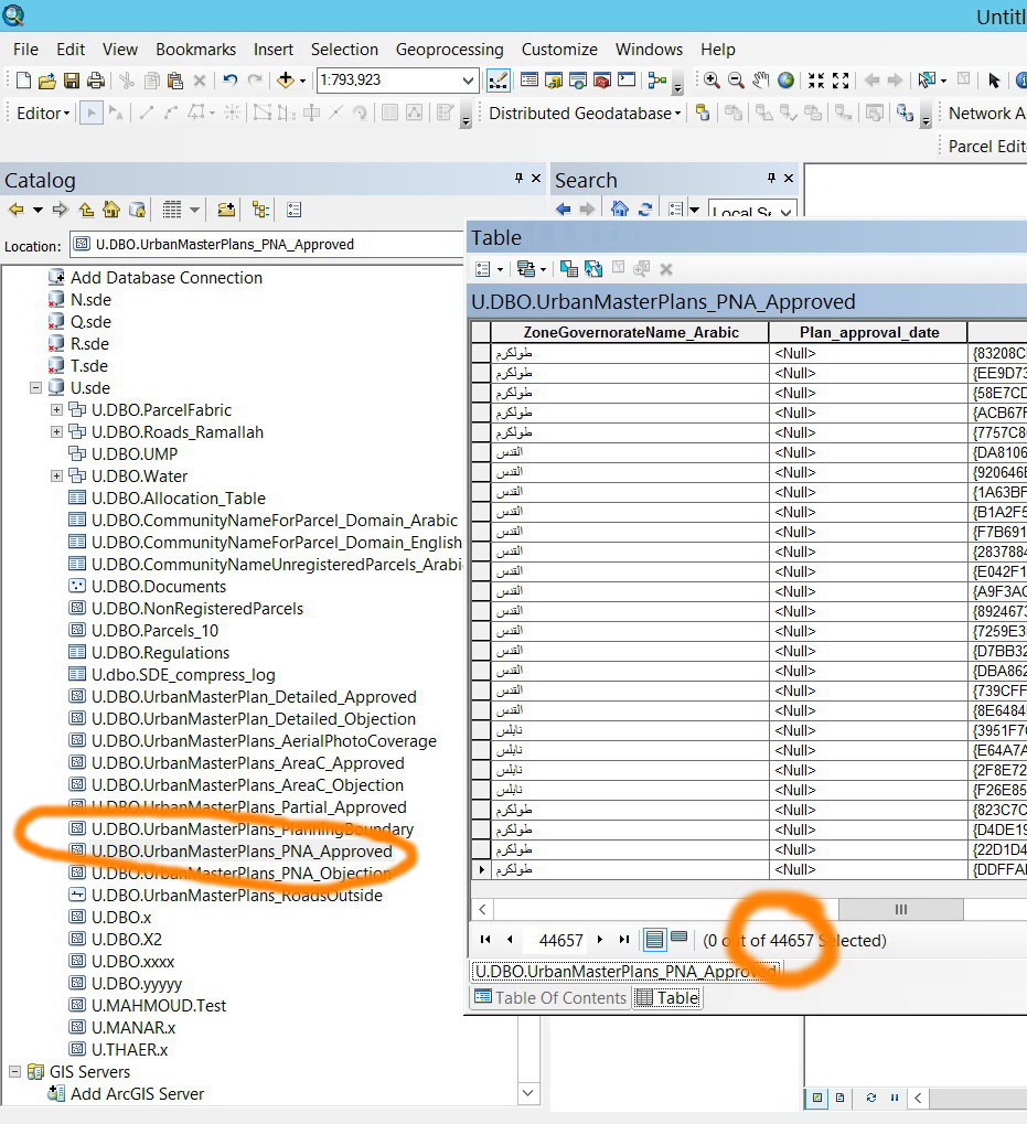
Now I�??m really in trouble due the data flow issues between file\enterprise databases. I can�??t transfer the data in both directions. Data will be lost
�?� Import\export\load data tools will apply the �??repair geometry�?� . The enterprise layer contains 44657 while the exported file layer is reduced to 42769
[ATTACH=CONFIG]33385[/ATTACH], [ATTACH=CONFIG]33386[/ATTACH]
�?� I wanted to apply topology for the layer in question but I couldn�??t copy\paste that layer to dataset to apply the topology.
[ATTACH=CONFIG]33387[/ATTACH]
�?� I tried to join the enterprise layer with the exported file layer to see which features are deleted, but it appears that the ArcGIS keeps giving the same error!
[ATTACH=CONFIG]33388[/ATTACH]
What might be the solution in this case?
----------------------------------------
Jamal Numan
Geomolg Geoportal for Spatial Information
Ramallah, West Bank, Palestine
Jamal Numan
Geomolg Geoportal for Spatial Information
Ramallah, West Bank, Palestine
by
Anonymous User
Not applicable
04-27-2014
02:18 AM
- Mark as New
- Bookmark
- Subscribe
- Mute
- Subscribe to RSS Feed
- Permalink
- Report Inappropriate Content
Original User: mboeringa2010
To follow up on this: I did now notice the "Check & Repair" step on loading data in an SDE Enterprise Geodatabase, is actually mentioned under the Repair Geometry Help topic:
"SDE geodatabases automatically check and repair feature geometries when the features are uploaded to the database, so using the Check Geometry and Repair Geometry tools with SDE feature classes is unnecessary."
This is some vital information missing from the ArcGIS for Desktop Help that might be added (by the way, in general I regard ESRI's Help and documentation efforts of a very high level, the Help and whitepapers are one huge reservoir of knowledge and of great use once you acquaint yourself with the basic jargon).
According to the Help, and running the Import option from ArcCatalog, the Import option is associated with the Feature Class to Feature Class tool. I don't see this "repair" step listed in the Help.
To follow up on this: I did now notice the "Check & Repair" step on loading data in an SDE Enterprise Geodatabase, is actually mentioned under the Repair Geometry Help topic:
"SDE geodatabases automatically check and repair feature geometries when the features are uploaded to the database, so using the Check Geometry and Repair Geometry tools with SDE feature classes is unnecessary."