Turn on suggestions
Auto-suggest helps you quickly narrow down your search results by suggesting possible matches as you type.
Cancel
- Home
- :
- All Communities
- :
- Products
- :
- ArcGIS Online
- :
- ArcGIS Online Questions
- :
- Images in pop-ups are not shown in all APIs
Options
- Subscribe to RSS Feed
- Mark Topic as New
- Mark Topic as Read
- Float this Topic for Current User
- Bookmark
- Subscribe
- Mute
- Printer Friendly Page
Images in pop-ups are not shown in all APIs
Subscribe
905
4
08-04-2011 07:28 AM
by
Anonymous User
Not applicable
08-04-2011
07:28 AM
- Mark as New
- Bookmark
- Subscribe
- Mute
- Subscribe to RSS Feed
- Permalink
- Report Inappropriate Content
Original User: thomas.ebert@ooe.gv.at
Original Date: 2011-08-04T08:28:15-0600
Pop-ups with images are a great tool in arcgis-online. However, GIF-images and ArcGIS-Server-REST-maps are not presented in all Viewers or iOS-App.
GIF-Image
- Works in ArcGIS.COM Viewer
- Does not work in ArcGIS Explorer Online (Silverlight)
- Works in the ArcGIS App for iOS
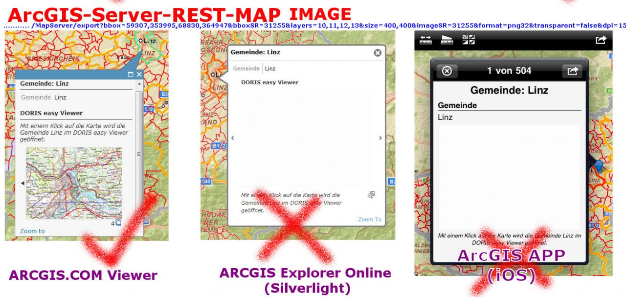
ArcGIS-Server-REST-Image
- Works in ArcGIS.COM Viewer
- Does not work in ArcGIS Explorer Online (Silverlight)
- Does not work in the ArcGIS App for iOS
Any ideas why?
Original Date: 2011-08-04T08:28:15-0600
Pop-ups with images are a great tool in arcgis-online. However, GIF-images and ArcGIS-Server-REST-maps are not presented in all Viewers or iOS-App.
GIF-Image
- Works in ArcGIS.COM Viewer
- Does not work in ArcGIS Explorer Online (Silverlight)
- Works in the ArcGIS App for iOS
ArcGIS-Server-REST-Image
- Works in ArcGIS.COM Viewer
- Does not work in ArcGIS Explorer Online (Silverlight)
- Does not work in the ArcGIS App for iOS
Any ideas why?
4 Replies
08-04-2011
10:57 AM
- Mark as New
- Bookmark
- Subscribe
- Mute
- Subscribe to RSS Feed
- Permalink
- Report Inappropriate Content
GIF Images are not supported by Microsoft Silverlight, which ArcGIS Explorer Online is built with. I'd suggest using a different image format like png.
I'm not sure why you're not seeing the REST images in Explorer Online and the iOS. Here's a URL that I'm using that works. The format I'm using is PNG and I assume you're using the &f=image option...I can't tell from your attachment.
http://services.arcgisonline.com/ArcGIS/rest/services/Specialty/World_Navigation_Charts/MapServer/ex...
If your server is behind a firewall, that could be a problem. You might need a client access policy file for Explorer Online, but I'm not sure. http://help.arcgis.com/en/arcgisexplorer/help/index.html#//01560000004p000000.htm
Hope this helps,
Mike
by
Anonymous User
Not applicable
08-04-2011
01:04 PM
- Mark as New
- Bookmark
- Subscribe
- Mute
- Subscribe to RSS Feed
- Permalink
- Report Inappropriate Content
Original User: doris123
Hi Mike,
thank you for your prompt reply and your info about using GIF-images.
Here is my map with an AGS-REST-image included in the pop-up which doesn't work in iOS App and Silverlight Explorer, but working well in Arcgis.com-Viewer.
http://www.arcgis.com/home/webmap/viewer.html?webmap=6add66c5e0f745a1ab556038bdd9770d
ColT
08-04-2011
03:26 PM
- Mark as New
- Bookmark
- Subscribe
- Mute
- Subscribe to RSS Feed
- Permalink
- Report Inappropriate Content
Not sure why...we'll have a look.
Thanks,
Mike
Thanks,
Mike
by
Anonymous User
Not applicable
08-04-2011
10:30 PM
- Mark as New
- Bookmark
- Subscribe
- Mute
- Subscribe to RSS Feed
- Permalink
- Report Inappropriate Content
Original User: doris123
Hello Mike,
it's seems to be a good way to sleep one night about it and then analyze the problem once again.
The solution is: to format the used attribute fields (min/max coordinates) without "1000 Separator" and "0 decimal places". And now also the iOS App and the Arcexplorer Online show the REST-Map. The Arcgiscom-Viewer seems to be more tolerant 😉
ColT