Turn on suggestions
Auto-suggest helps you quickly narrow down your search results by suggesting possible matches as you type.
Cancel
- Home
- :
- All Communities
- :
- Products
- :
- Data Management
- :
- Data Management Questions
- :
- Help with solving error 9999 Project Raster
Options
- Subscribe to RSS Feed
- Mark Topic as New
- Mark Topic as Read
- Float this Topic for Current User
- Bookmark
- Subscribe
- Mute
- Printer Friendly Page
Help with solving error 9999 Project Raster
Subscribe
6444
2
08-03-2011 01:58 AM
by
Anonymous User
Not applicable
08-03-2011
01:58 AM
- Mark as New
- Bookmark
- Subscribe
- Mute
- Subscribe to RSS Feed
- Permalink
- Report Inappropriate Content
Original User: rubenrommens
Hi guys,
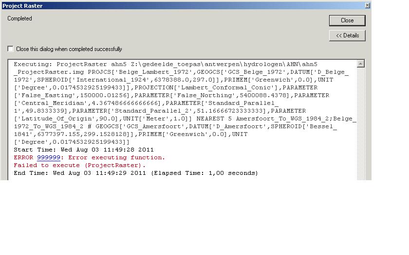
When converting a raster using "project raster" (Attachment "screenshot1" ) which is based on the "Amersfoort" projection to "Belge Lambert1972" I receive error 9999 ( "Screenshot2").
I've taken a look at the log file but it doesn't help me much further.
Can anyone help me with this?
- <ResultViews>
- <ResultView Tool="Project Raster">
<CommandLine>ProjectRaster_management ahn5 Z:\gedeelde_toepas\antwerpen\hydrologen\AHN\ahn5_ProjectRaster.img PROJCS['Belge_Lambert_1972',GEOGCS['GCS_Belge_1972',DATUM['D_Belge_1972',SPHEROID['International_1924',6378388.0,297.0]],PRIMEM['Greenwich',0.0],UNIT['Degree',0.0174532925199433]],PROJECTION['Lambert_Conformal_Conic'],PARAMETER['False_Easting',150000.01256],PARAMETER['False_Northing',5400088.4378],PARAMETER['Central_Meridian',4.367486666666666],PARAMETER['Standard_Parallel_1',49.8333339],PARAMETER['Standard_Parallel_2',51.16666723333333],PARAMETER['Latitude_Of_Origin',90.0],UNIT['Meter',1.0]] NEAREST 5 Amersfoort_To_WGS_1984_2;Belge_1972_To_WGS_1984_2 # GEOGCS['GCS_Amersfoort',DATUM['D_Amersfoort',SPHEROID['Bessel_1841',6377397.155,299.1528128]],PRIMEM['Greenwich',0.0],UNIT['Degree',0.0174532925199433]]</CommandLine>
<ToolSource>F:\Apps\ArcGIS\ArcToolbox\Toolboxes\Data Management Tools.tbx\Projections and Transformations\Raster\ProjectRaster</ToolSource>
<StartTime>Wed Aug 03 11:05:25 2011</StartTime>
- <Parameters>
- <Inputs>
<Parameter Label="Input Raster" Type="Layer">ahn5</Parameter>
<Parameter Label="Output Coordinate System" Type="Scalar">PROJCS['Belge_Lambert_1972',GEOGCS['GCS_Belge_1972',DATUM['D_Belge_1972',SPHEROID['International_1924',6378388.0,297.0]],PRIMEM['Greenwich',0.0],UNIT['Degree',0.0174532925199433]],PROJECTION['Lambert_Conformal_Conic'],PARAMETER['False_Easting',150000.01256],PARAMETER['False_Northing',5400088.4378],PARAMETER['Central_Meridian',4.367486666666666],PARAMETER['Standard_Parallel_1',49.8333339],PARAMETER['Standard_Parallel_2',51.16666723333333],PARAMETER['Latitude_Of_Origin',90.0],UNIT['Meter',1.0]]</Parameter>
<Parameter Label="Resampling Techinque" Type="Scalar">NEAREST</Parameter>
<Parameter Label="Output Cell Size" Type="Scalar">5</Parameter>
<Parameter Label="Geographic Transformation" Type="Scalar">Amersfoort_To_WGS_1984_2;Belge_1972_To_WGS_1984_2</Parameter>
<Parameter Label="Input Coordinate System" Type="Scalar">GEOGCS['GCS_Amersfoort',DATUM['D_Amersfoort',SPHEROID['Bessel_1841',6377397.155,299.1528128]],PRIMEM['Greenwich',0.0],UNIT['Degree',0.0174532925199433]]</Parameter>
</Inputs>
- <Outputs>
<Parameter Label="Output Raster Dataset" Type="Dataset">Z:\gedeelde_toepas\antwerpen\hydrologen\AHN\ahn5_ProjectRaster.img</Parameter>
</Outputs>
- <LayerInfo>
<Layer Name="ahn5">Z:\gedeelde_toepas\antwerpen\hydrologen\AHN\ahn5\Ahn5</Layer>
</LayerInfo>
</Parameters>
- <Environments>
<Environment Label="Precision For New Coverages">SINGLE</Environment>
<Environment Label="Auto Commit">1000</Environment>
<Environment Label="Minimize memory use during analysis on terrains">false</Environment>
<Environment Label="Compression">LZ77</Environment>
<Environment Label="Coincident Points">MEAN</Environment>
<Environment Label="Random number generator">0 ACM599</Environment>
<Environment Label="Raster Statistics">STATISTICS 1 1</Environment>
<Environment Label="Level Of Comparison Between Projection Files">NONE</Environment>
<Environment Label="Output has Z Values">Same As Input</Environment>
<Environment Label="Maintain fully qualified field names">true</Environment>
<Environment Label="Tile Size">128 128</Environment>
<Environment Label="Pyramid">PYRAMIDS -1 NEAREST</Environment>
<Environment Label="Output Spatial Grid 1">0</Environment>
<Environment Label="Cell Size">MAXOF</Environment>
<Environment Label="Output has M Values">Same As Input</Environment>
<Environment Label="Output Spatial Grid 2">0</Environment>
<Environment Label="Output Spatial Grid 3">0</Environment>
<Environment Label="Precision For Derived Coverages">HIGHEST</Environment>
</Environments>
- <Errors>
<Error>ERROR 999999: Error executing function.</Error>
<Error>Failed to execute (ProjectRaster).</Error>
</Errors>
<EndTime>Wed Aug 03 11:05:26 2011</EndTime>
<ElapsedTime>1,00 seconds</ElapsedTime>
</ResultView>
</ResultViews>Can anybody help me with solving this error?
Kind Regards,
Ruben
Hi guys,
When converting a raster using "project raster" (Attachment "screenshot1" ) which is based on the "Amersfoort" projection to "Belge Lambert1972" I receive error 9999 ( "Screenshot2").
I've taken a look at the log file but it doesn't help me much further.
Can anyone help me with this?
- <ResultViews>
- <ResultView Tool="Project Raster">
<CommandLine>ProjectRaster_management ahn5 Z:\gedeelde_toepas\antwerpen\hydrologen\AHN\ahn5_ProjectRaster.img PROJCS['Belge_Lambert_1972',GEOGCS['GCS_Belge_1972',DATUM['D_Belge_1972',SPHEROID['International_1924',6378388.0,297.0]],PRIMEM['Greenwich',0.0],UNIT['Degree',0.0174532925199433]],PROJECTION['Lambert_Conformal_Conic'],PARAMETER['False_Easting',150000.01256],PARAMETER['False_Northing',5400088.4378],PARAMETER['Central_Meridian',4.367486666666666],PARAMETER['Standard_Parallel_1',49.8333339],PARAMETER['Standard_Parallel_2',51.16666723333333],PARAMETER['Latitude_Of_Origin',90.0],UNIT['Meter',1.0]] NEAREST 5 Amersfoort_To_WGS_1984_2;Belge_1972_To_WGS_1984_2 # GEOGCS['GCS_Amersfoort',DATUM['D_Amersfoort',SPHEROID['Bessel_1841',6377397.155,299.1528128]],PRIMEM['Greenwich',0.0],UNIT['Degree',0.0174532925199433]]</CommandLine>
<ToolSource>F:\Apps\ArcGIS\ArcToolbox\Toolboxes\Data Management Tools.tbx\Projections and Transformations\Raster\ProjectRaster</ToolSource>
<StartTime>Wed Aug 03 11:05:25 2011</StartTime>
- <Parameters>
- <Inputs>
<Parameter Label="Input Raster" Type="Layer">ahn5</Parameter>
<Parameter Label="Output Coordinate System" Type="Scalar">PROJCS['Belge_Lambert_1972',GEOGCS['GCS_Belge_1972',DATUM['D_Belge_1972',SPHEROID['International_1924',6378388.0,297.0]],PRIMEM['Greenwich',0.0],UNIT['Degree',0.0174532925199433]],PROJECTION['Lambert_Conformal_Conic'],PARAMETER['False_Easting',150000.01256],PARAMETER['False_Northing',5400088.4378],PARAMETER['Central_Meridian',4.367486666666666],PARAMETER['Standard_Parallel_1',49.8333339],PARAMETER['Standard_Parallel_2',51.16666723333333],PARAMETER['Latitude_Of_Origin',90.0],UNIT['Meter',1.0]]</Parameter>
<Parameter Label="Resampling Techinque" Type="Scalar">NEAREST</Parameter>
<Parameter Label="Output Cell Size" Type="Scalar">5</Parameter>
<Parameter Label="Geographic Transformation" Type="Scalar">Amersfoort_To_WGS_1984_2;Belge_1972_To_WGS_1984_2</Parameter>
<Parameter Label="Input Coordinate System" Type="Scalar">GEOGCS['GCS_Amersfoort',DATUM['D_Amersfoort',SPHEROID['Bessel_1841',6377397.155,299.1528128]],PRIMEM['Greenwich',0.0],UNIT['Degree',0.0174532925199433]]</Parameter>
</Inputs>
- <Outputs>
<Parameter Label="Output Raster Dataset" Type="Dataset">Z:\gedeelde_toepas\antwerpen\hydrologen\AHN\ahn5_ProjectRaster.img</Parameter>
</Outputs>
- <LayerInfo>
<Layer Name="ahn5">Z:\gedeelde_toepas\antwerpen\hydrologen\AHN\ahn5\Ahn5</Layer>
</LayerInfo>
</Parameters>
- <Environments>
<Environment Label="Precision For New Coverages">SINGLE</Environment>
<Environment Label="Auto Commit">1000</Environment>
<Environment Label="Minimize memory use during analysis on terrains">false</Environment>
<Environment Label="Compression">LZ77</Environment>
<Environment Label="Coincident Points">MEAN</Environment>
<Environment Label="Random number generator">0 ACM599</Environment>
<Environment Label="Raster Statistics">STATISTICS 1 1</Environment>
<Environment Label="Level Of Comparison Between Projection Files">NONE</Environment>
<Environment Label="Output has Z Values">Same As Input</Environment>
<Environment Label="Maintain fully qualified field names">true</Environment>
<Environment Label="Tile Size">128 128</Environment>
<Environment Label="Pyramid">PYRAMIDS -1 NEAREST</Environment>
<Environment Label="Output Spatial Grid 1">0</Environment>
<Environment Label="Cell Size">MAXOF</Environment>
<Environment Label="Output has M Values">Same As Input</Environment>
<Environment Label="Output Spatial Grid 2">0</Environment>
<Environment Label="Output Spatial Grid 3">0</Environment>
<Environment Label="Precision For Derived Coverages">HIGHEST</Environment>
</Environments>
- <Errors>
<Error>ERROR 999999: Error executing function.</Error>
<Error>Failed to execute (ProjectRaster).</Error>
</Errors>
<EndTime>Wed Aug 03 11:05:26 2011</EndTime>
<ElapsedTime>1,00 seconds</ElapsedTime>
</ResultView>
</ResultViews>Can anybody help me with solving this error?
Kind Regards,
Ruben
2 Replies
by
Anonymous User
Not applicable
08-03-2011
12:01 PM
- Mark as New
- Bookmark
- Subscribe
- Mute
- Subscribe to RSS Feed
- Permalink
- Report Inappropriate Content
Original User: mkennedy
Hi Ruben,
I don't work with rasters as much as I should. So the input raster's coordinate system is geographic? That is, lat/lon, rather than RD New (based on Amersfoort)? Sometimes that error is given if the input data's coordinate system isn't correct. Otherwise, I would try a different output raster format and try to reproject the data in ArcMap. You won't be able to set the transformations, but it would be useful to see if it works at all.
Melita
by
Anonymous User
Not applicable
08-04-2011
05:12 AM
- Mark as New
- Bookmark
- Subscribe
- Mute
- Subscribe to RSS Feed
- Permalink
- Report Inappropriate Content
Original User: rubenrommens
Hi melissa,
Thanks for your answer ! changing the input coordinate system to RD_new solved the problem.
Thanks for the help !
Ruben
Hi melissa,
Thanks for your answer ! changing the input coordinate system to RD_new solved the problem.
Thanks for the help !
Ruben