Turn on suggestions
Auto-suggest helps you quickly narrow down your search results by suggesting possible matches as you type.
Cancel
- Home
- :
- All Communities
- :
- Products
- :
- Geoprocessing
- :
- Geoprocessing Questions
- :
- Error during Run of ModelBuilder Script
Options
- Subscribe to RSS Feed
- Mark Topic as New
- Mark Topic as Read
- Float this Topic for Current User
- Bookmark
- Subscribe
- Mute
- Printer Friendly Page
Error during Run of ModelBuilder Script
Subscribe
814
3
04-04-2011 08:49 AM
by
Anonymous User
Not applicable
04-04-2011
08:49 AM
- Mark as New
- Bookmark
- Subscribe
- Mute
- Subscribe to RSS Feed
- Permalink
- Report Inappropriate Content
Original User: nomeus
Dear ArcGIS-Professionals,
i try to generate a schematic diagram out of a busline network with the model builder.
During the Run of the Model, there is an error which tells me, that the file
already exists - even if i rename the output name of the diagram or the other layers.
After enabling the "overwrite" function of the geoprocessing options,
the problem is the same.
Before i start running the model, the output folder (a schematic datatset) is empty.
I don`t find a reason for this problem. Does anybody has an idea?
I attached some screenshots to better understand my problem:
- My schematic Model
- Geoprocessing options
- Error notice of the "create diagram" tool in the model
- Error during the run
- python script of the model
Best regards,
Stefan
3 Replies
by
Anonymous User
Not applicable
04-06-2011
05:22 AM
- Mark as New
- Bookmark
- Subscribe
- Mute
- Subscribe to RSS Feed
- Permalink
- Report Inappropriate Content
Original User: nomeus
I found out, that the problem is already in the step of solving the route with the modelbuilder (load location tool) instead of choose the stops manually. Does anybody know if if there is an essential difference? Or has anybody experience with it?
For instance:
When i add the Network Dataset to my Data Frame, then Create a new Route and pick a few points with my mouse. Then i click the solve button and see the solved route. I can use this route to create a schematic diagram.
On the other hand, when i use the load location tool to solve the route (like the procedure in the modelbuilder), on the first view the result looks very similar. Of course instead of choosing the stops of the route manually, this were chosen out of the points in the shapefile. But i already tried to put the graphic picks exactly at the same position (as good as possible) like the points out of the shapefile.
The solved route seems to be exactly the same! But to create an Diagram out of it is impossible. I don`t know why.
I tried it with 2 Network Datasets and different Point-Shapefiles.
The Point-Shapefiles in my test only consists 3 or 4 Points, which were directly connected to an edge on the ND. But additionally the Tolerance and Snapping Function are activated. I`m using ArcGIS Desktop 10.
04-07-2011
03:07 AM
- Mark as New
- Bookmark
- Subscribe
- Mute
- Subscribe to RSS Feed
- Permalink
- Report Inappropriate Content
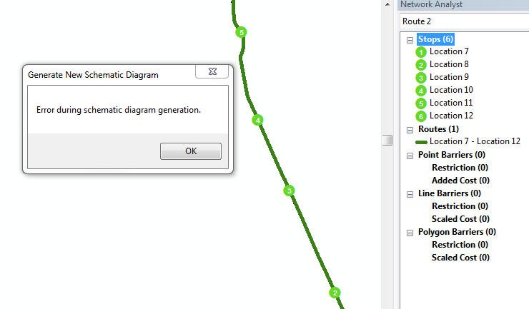
Still the same Problem, but more information:
When i want to create the Diagram with a solved route, there are different ways to choose the stops of the route:
1.) When i use Graphic Picks (chosen manually) --> It works
2.) When i use a self-created Shapefile with manually chosen points + Load Location tool --> It works
3.) When i use a Shapefile with randomly chosen stops out of the original Busstop-Databse + load location tool --> The error occurs.
But the route can always be solved and looks fine!
I can`t understand this problem and have no idea how this can happen ...
by
Anonymous User
Not applicable
04-07-2011
02:28 PM
- Mark as New
- Bookmark
- Subscribe
- Mute
- Subscribe to RSS Feed
- Permalink
- Report Inappropriate Content
Original User: 4233
We will have to look into it. Somehow the selection set is being seen differently by Schematics and causing the issue. It would be best to log this in through esri support so it can be tracked appropriately.
We will have to look into it. Somehow the selection set is being seen differently by Schematics and causing the issue. It would be best to log this in through esri support so it can be tracked appropriately.