- Home
- :
- All Communities
- :
- Products
- :
- ArcGIS Spatial Analyst
- :
- ArcGIS Spatial Analyst Questions
- :
- Ordnance Survey Historical Mapping, Raster Catalog...
- Subscribe to RSS Feed
- Mark Topic as New
- Mark Topic as Read
- Float this Topic for Current User
- Bookmark
- Subscribe
- Mute
- Printer Friendly Page
Ordnance Survey Historical Mapping, Raster Catalogs and assigning NoData
- Mark as New
- Bookmark
- Subscribe
- Mute
- Subscribe to RSS Feed
- Permalink
- Report Inappropriate Content
Hoping someone can help. I have 4000+ OS Historic Mapping geotiffs which I need to put into product-specific (i.e. scale of map + epoch) raster catalogs. I am adding the dates to each raster as an attribute to the individual rasters inside the catalogs in order to use the ArcMap time slider tools.
A problem we are having is that we need to set the “white” to be NoData because in some cases the rasters (we have acquired these from a 3rd party supplier) have large white areas within them, which means that they “block” out visibility of other overlapping tiles. These are black and white maps (or *many* shades of grey, it's not consistent) - so we also need to remove the "white" from within the map tile itself so as our other base mapping products can be displayed underneath.
If this white value from within the ColorMap for all of these rasters was consistent I could change this, but, it is completely randomly assigned (i.e. “1”, or “63”) throughout the bundle of rasters we ahve. It appears that the supplier has not been consistent with these.
I have read that it is better to store this data in mosaic datasets, but we cannot use a mosaic dataset as we need to serve these up also via our Geocortex web solution, and we do not have Image Server.
I’ve tried importing the geotiffs into a raster dataset before adding to a raster catalog but this does not resolve the problem (I'd previously just added the raw geotiffs into the catalog).
Any ideas?
We are using ArcGIS 10.1..
Thanks in advance,
Katie Lysons
Solved! Go to Solution.
Accepted Solutions
- Mark as New
- Bookmark
- Subscribe
- Mute
- Subscribe to RSS Feed
- Permalink
- Report Inappropriate Content
Landmark Historic mapping are only 1 band GeoTiffs.
When being loaded into a Raster Catalog the colormap is causing the problem as you specified.
Deleting all the values under the colormap will display all the GeoTiffs as stretched when loaded into a Raster Catalog
The process is found below.
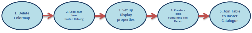
Using the "Delete Colormap" tool found in the Data Management Tools under the Raster tool set, on all the GeoTiffs before placing them into a Raster Catalog. This removes the colormap values.
Once this process has finished load all the rasters into a Raster Catalog.
When displaying the Raster Catalog containing all the Historical Mapping click on properties and select the symbology tab. (Note under the Colormap option no values are displayed) Select to display the Catalog as Stretched, Tick the box next to "Display Background Value:" and type in a value of "1". Once this is applied the White value ("1") will show as null color and all tiles will be visible overlapping each other
You can now join this to any Tables or Vector files with containing the Dates for each tile, and use the Time slider tool against it.
This will fix the problem
Regards
Lewis George
- Mark as New
- Bookmark
- Subscribe
- Mute
- Subscribe to RSS Feed
- Permalink
- Report Inappropriate Content
Landmark Historic mapping are only 1 band GeoTiffs.
When being loaded into a Raster Catalog the colormap is causing the problem as you specified.
Deleting all the values under the colormap will display all the GeoTiffs as stretched when loaded into a Raster Catalog
The process is found below.
Using the "Delete Colormap" tool found in the Data Management Tools under the Raster tool set, on all the GeoTiffs before placing them into a Raster Catalog. This removes the colormap values.
Once this process has finished load all the rasters into a Raster Catalog.
When displaying the Raster Catalog containing all the Historical Mapping click on properties and select the symbology tab. (Note under the Colormap option no values are displayed) Select to display the Catalog as Stretched, Tick the box next to "Display Background Value:" and type in a value of "1". Once this is applied the White value ("1") will show as null color and all tiles will be visible overlapping each other
You can now join this to any Tables or Vector files with containing the Dates for each tile, and use the Time slider tool against it.
This will fix the problem
Regards
Lewis George