- Home
- :
- All Communities
- :
- Products
- :
- ArcGIS for AutoCAD
- :
- ArcGIS for AutoCAD Questions
- :
- Welcome to the New ArcGIS for AutoCAD Group
- Subscribe to RSS Feed
- Mark Topic as New
- Mark Topic as Read
- Float this Topic for Current User
- Bookmark
- Subscribe
- Mute
- Printer Friendly Page
Welcome to the New ArcGIS for AutoCAD Group
- Mark as New
- Bookmark
- Subscribe
- Mute
- Subscribe to RSS Feed
- Permalink
- Report Inappropriate Content
This is the start of the ArcGIS for AutoCAD Group.
- Mark as New
- Bookmark
- Subscribe
- Mute
- Subscribe to RSS Feed
- Permalink
- Report Inappropriate Content
Thanks, Don, for creating this group!
- Mark as New
- Bookmark
- Subscribe
- Mute
- Subscribe to RSS Feed
- Permalink
- Report Inappropriate Content
Hello,
Glad I recently found this forum. I am having difficulty with the Find and Replace command in ARCGIS FOR AUTOCAD 350 working with C3D 2013 not functioning within a reasonable time or at all. I created several large feature classes defined solely by geometry type and specific feature classes defined by geometry and specific layers. Since the attribute fields are the same for each local feature class, I typically update the large feature classes (defined by the * value for the layer property) and the specific feature classes are updated automatically. It's a big time saver. My question applies to the Find and Replace tool when trying to edit attributes in a large feature class (for example, my TEMP_LN feature class has over 77,000 entities). I've have let the command run for 15 minutes or more and nothing happens. Is this a common issue? Also, can the Find and Replace tool, replace lower case values with identical upper case values?
Thank you,
Matt
- Mark as New
- Bookmark
- Subscribe
- Mute
- Subscribe to RSS Feed
- Permalink
- Report Inappropriate Content
I am not familiar with any particular issue with the FIND and Replace Tool in the table viewer. Perhaps you could send me a copy of the drawing or I could create one that is similar. What are the TYPES of fields you are attempting to update and what values are you typically replacing? Might also be easy to whip up a little AutoLISP to be more targeted. I like your clever use of the Super-Set of feature classes I do that too sometimes.
- Mark as New
- Bookmark
- Subscribe
- Mute
- Subscribe to RSS Feed
- Permalink
- Report Inappropriate Content
Unfortunately, I can not provide a copy of the drawing. Below I've attached the local feature class properties. I am attempting to standardize the text attribute fields by a) replacing lower case entries with upper case, b) replacing text which includes numerical values to text only and c) adding folder paths to DRAWING_IDs without. 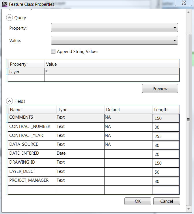
In order to improve the process, I have also created a feature dataset (in an enterprise geodatabase) with the local feature class CAD data (with domain constraints) and published the feature classes to a feature service. Unfortunately, not all feature classes will extract in ARCGIS FOR AUTOCAD. I am assuming this may be due to CAD entities such as ellipses and splines. All feature classes can be utilized in ARCMAP, though.
Thanks for replying so promptly,
Matt
- Mark as New
- Bookmark
- Subscribe
- Mute
- Subscribe to RSS Feed
- Permalink
- Report Inappropriate Content
As far as FIND and REPLACE. Yes it can take that long.
Now for Ellipses and Splines those should be working. If you suspect an issue with a geometry make sure it is not a Civil 3D custom entity. Ellipses and splines should be fine.
I would also suggest you take a look at the ESRI_CALCULATEFIELD command in the ArcGIS for AutoCAD BONUS Tools found here; http://www.arcgis.com/home/item.html?id=103f4d42de804f4ab42ff498026d9ddc
The bonus tool, ESRI_CALCULATEFIELD command can accept AutoLISP functions to perform interesting field calculations. Square brackets [ ] allow you to use the field value within the expression that gets applied to each of the selected features. There is documentation for the bonus tools in the .zip download. Whatever the AutoLISP expression return as its value will be used as the value for the chosen field for that feature. The AutoLISP can be simple or really complex.
I was testing ESRI_CALCULATEFIELD on 90,000 features and a simple expression takes about 20 minutes to process on my machine (about 60 features per second)... 70000 features is a lot of iterations even for sub-second transactions.
I had to abandon my test using FIND and REPLACE in the table viewer. But if you think about it it is checking all of the fields in those 70000 features and that could take many times as long...
Using the Bonus tool: ESRI_CALCULATEFIELD This example would be a way to force all the values in the "product_manager" text field to uppercase. Enter this as the "expression". It will be evaluated for each feature:
(strcase [PROJECT_MANAGER])
This example expression would append "C:/myPath/" to the current value of each feature for the data_source field:
(strcat "C:/mypath/" [DATA_SOURCE])
There is also a documented BONUS AutoLISP function version
(esri_featureclass_calculatefield FNAME SUBTYPE EXPRESSION )
This would allow you to automate multiple field calculations and launch it on your 70000 features before you go home.
- Mark as New
- Bookmark
- Subscribe
- Mute
- Subscribe to RSS Feed
- Permalink
- Report Inappropriate Content
Thank you for posting suggestions regarding the autolisp routines. I will give them a try and post the results. Ultimately I would like to do all the editing in a feature service, but as of now, the feature service I have created does not properly query all the data in ARCGIS FOR AUTOCAD. I get the following error: 
With some feature services , I get part of the geometry queried in ARCGIS FOR AUTOCAD, while in others the query is blank. All geometry is visible when feature classes in the enterprise database (from which the feature service is linked to)
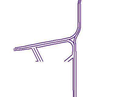
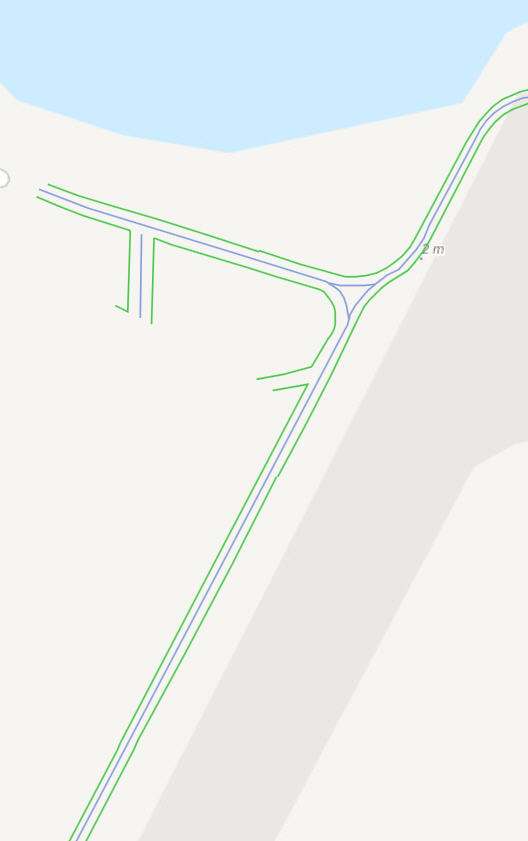
are imported into ARCMAP. For example, when I querying the VSRD_LN feature class in ARCMAP and in ARCGIS FOR AUTOCAD, I get the following:
ARCMAP:
ARCGIS FOR AUTOCAD:
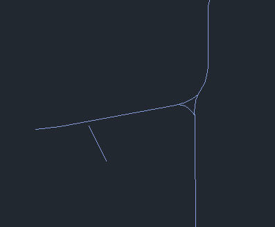
I can not figure out why many of the lines are missing upon querying this particular feature service to ARCGIS TO AUTOCAD. In this particular instance, the linework is comprised of lines, and various polyline types.
Any suggestions as to possible issues would be greatly appreciated.
- Mark as New
- Bookmark
- Subscribe
- Mute
- Subscribe to RSS Feed
- Permalink
- Report Inappropriate Content
Is this data part of a network data? If so the drawing and the feature class need to be in the same coordinate system.
Other things you could do to help isolate the problem, is to take ArcGIS for AutoCAD out of the equation, by creating a Map in on ArcGIS.com and include the feature service and see if they all are showing up there. ArcMap is accessing the feature service in a different way, so the test is not as valid. ArcGIS for AutoCAD is slightly different than the web map, but it is a better test.
If the web map has issues we can focus our attention on the data, if the web map is similar to ArcMap we can continue looking at the geometry in AutoCAD.
- Mark as New
- Bookmark
- Subscribe
- Mute
- Subscribe to RSS Feed
- Permalink
- Report Inappropriate Content
The data is not part of a network. It originated from various CAD entities that were imported (as feature classes) to a feature dataset within a file geodatabase. There were no rules assigned. The features classes from the file geodatabase were then imported to a feature dataset within our enterprise database. The contents of said feature dataset were then shared as a feature service and imported into ARCGIS FOR AUTOCAD. The drawing and the feature class are in the same coordinate system.
The map below was successfully created in ARCGIS ONLINE from the same feature service as posted above:
Another test I did was export the feature class out of the enterprise GDB feature dataset, directly into the enterprise GDB. Said feature class was then shared as a feature service but the results were the same in ARCGIS FOR AUTOCAD.
No issues are apparent when exporting to CAD directly from the enterprise geodatabase. Unfortunately, this process creates densified polylines from polylines containing both lines and arcs. From my understanding and evidenced by features successfully extracted, the only way to maintain the original geometry is to use feature services.
- Mark as New
- Bookmark
- Subscribe
- Mute
- Subscribe to RSS Feed
- Permalink
- Report Inappropriate Content
If you could send a representative AutoCAD file (with coordinate esri system) with just a couple entities that you think would show the problem, I'd could try to recreate your setup? I would take your drawing then migrate it to an enterprise GDB and then create a feature service like you did and try accessing those services in AFA.