- Home
- :
- All Communities
- :
- Products
- :
- ArcGIS Spatial Analyst
- :
- ArcGIS Spatial Analyst Questions
- :
- Cost Distance Extent Problem
- Subscribe to RSS Feed
- Mark Topic as New
- Mark Topic as Read
- Float this Topic for Current User
- Bookmark
- Subscribe
- Mute
- Printer Friendly Page
- Mark as New
- Bookmark
- Subscribe
- Mute
- Subscribe to RSS Feed
- Permalink
- Report Inappropriate Content
Hi! I am kind of new to ArcGIS and I would appreciate some help
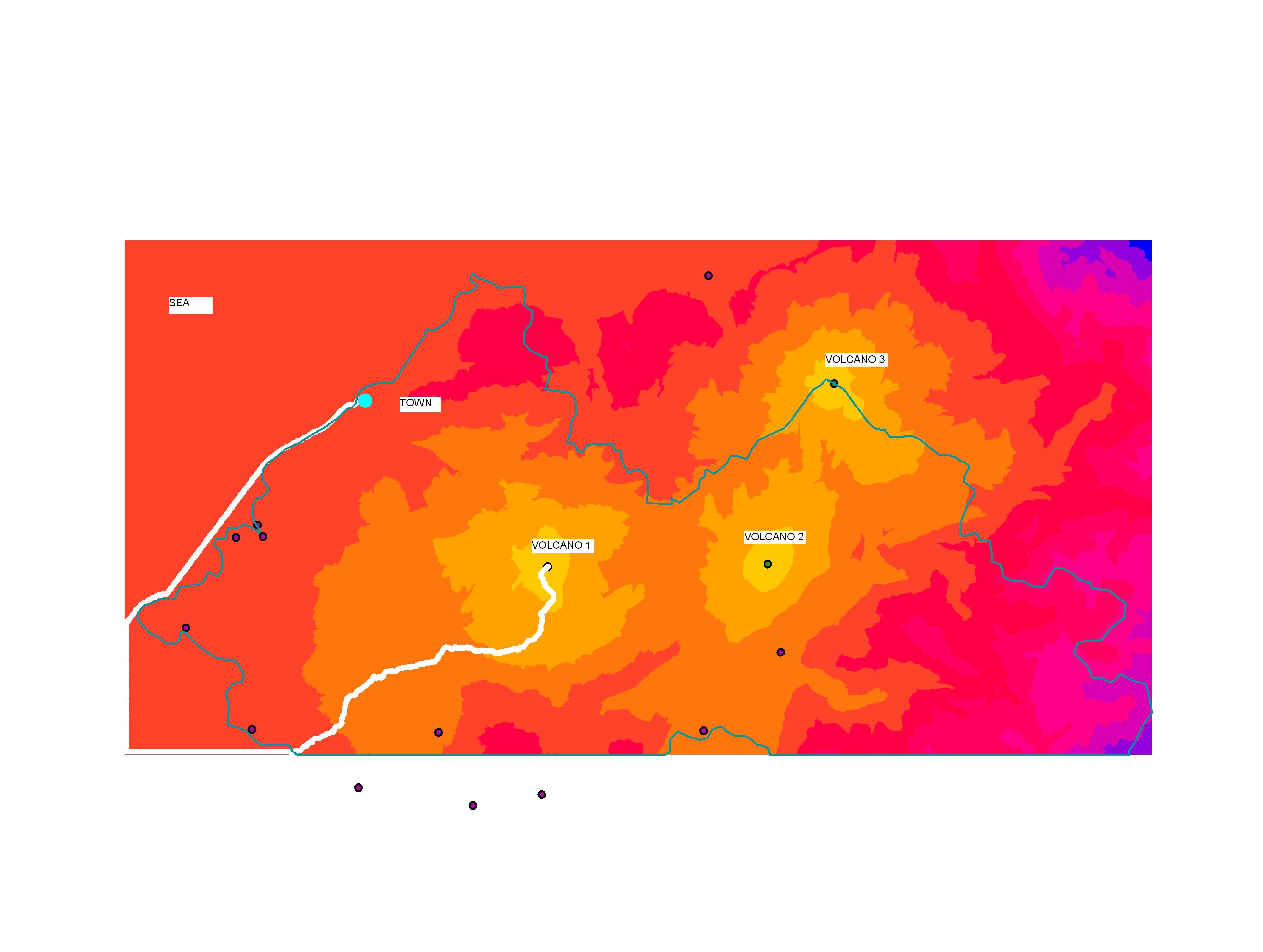
I am carrying a cost path analysis over a piece of land and i am getting a strange answer I can not turn it right. I am assessing the least costly path between a coastal town -destination- and a series of three volcanoes -source- (based on which I created a cost distance raster). The boundary of the image attached shows the coast line. The resulting least costly path runs over the sea instead of facing directly a shorter path towards the closest volcano.
I suspect It has something to do with the extent and environmental setting of the cost distance or cost path tool. But I can not get it right.
Any help greatly appreciated!
Solved! Go to Solution.
Accepted Solutions
- Mark as New
- Bookmark
- Subscribe
- Mute
- Subscribe to RSS Feed
- Permalink
- Report Inappropriate Content
Juan,
After doing more research you should actually be setting the water cells to NoData.
Cell locations with NoData in the input cost raster act as barriers in the cost surface functions. Any cell location that is assigned NoData on the input cost surface will receive NoData on all outputs (cost distance raster and, optionally, cost backlink raster).
You can also use one of the extract by tools to create another raster to set a boundary to your analysis
http://help.arcgis.com/en/arcgisdesktop/10.0/help/index.html#/Extract_by_Polygon/009z0000002q000000/
- Mark as New
- Bookmark
- Subscribe
- Mute
- Subscribe to RSS Feed
- Permalink
- Report Inappropriate Content
Juan,
You have to assign the highest value to cells that are in the water in your weighted raster so that the analysis will not choose to go that route. Let me know if you don't understand.
- Mark as New
- Bookmark
- Subscribe
- Mute
- Subscribe to RSS Feed
- Permalink
- Report Inappropriate Content
Thank you Robert.
I get your point. I gave it a try to a couple of attempts this morning by only changing the cell value, but it did not work. So far I have been only using a slope raster in order to create the cost distance surface. I have not used a landuse raster that can give me the chance to give a high value to cells in water.
I will search for a landuse raster and follow the way you suggest and let you know. Thanks!
- Mark as New
- Bookmark
- Subscribe
- Mute
- Subscribe to RSS Feed
- Permalink
- Report Inappropriate Content
Juan,
After doing more research you should actually be setting the water cells to NoData.
Cell locations with NoData in the input cost raster act as barriers in the cost surface functions. Any cell location that is assigned NoData on the input cost surface will receive NoData on all outputs (cost distance raster and, optionally, cost backlink raster).
You can also use one of the extract by tools to create another raster to set a boundary to your analysis
http://help.arcgis.com/en/arcgisdesktop/10.0/help/index.html#/Extract_by_Polygon/009z0000002q000000/
- Mark as New
- Bookmark
- Subscribe
- Mute
- Subscribe to RSS Feed
- Permalink
- Report Inappropriate Content
Thank you Robert,
I assigned no data to water and it worked perfectly!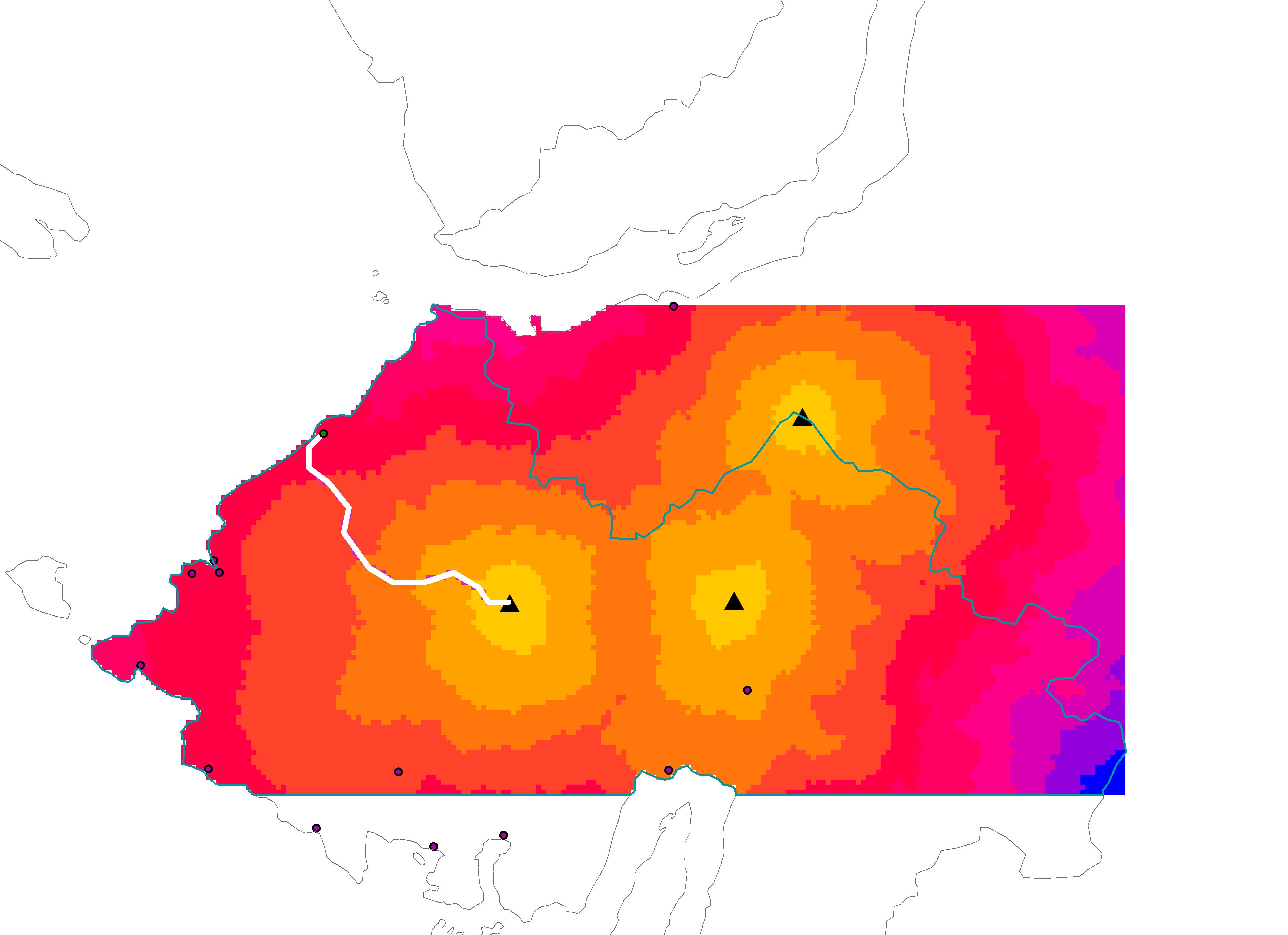
- Mark as New
- Bookmark
- Subscribe
- Mute
- Subscribe to RSS Feed
- Permalink
- Report Inappropriate Content
I've moved your post into the Spatial Analyst space. You will get a much better answer here as the GeoNet Help is intended for community help and feedback. You can see more on the community structure, and what topics are under each space from the following documents:
ArcGIS Discussion Forums Migration Strategy
Thanks!
Timothy
- Mark as New
- Bookmark
- Subscribe
- Mute
- Subscribe to RSS Feed
- Permalink
- Report Inappropriate Content
Juan,
Glad I could help. Now you can help by marking my reply about the no data as the "Correct Answer". Just click on the link that looks like this on my reply.
