Turn on suggestions
Auto-suggest helps you quickly narrow down your search results by suggesting possible matches as you type.
Cancel
- Home
- :
- All Communities
- :
- Industries
- :
- Water Resources
- :
- Water Resources Questions
- :
- Depression Evaluation Error
Options
- Subscribe to RSS Feed
- Mark Topic as New
- Mark Topic as Read
- Float this Topic for Current User
- Bookmark
- Subscribe
- Mute
- Printer Friendly Page
Depression Evaluation Error
Subscribe
02-09-2014
05:18 PM
- Mark as New
- Bookmark
- Subscribe
- Mute
- Subscribe to RSS Feed
- Permalink
- Report Inappropriate Content
When using the Terrain Preprocesing > DEM Manipulation > Depression Evaluation tool, I get the same error message every time I run it. I have a DEM file that I've been using for other layers (slope, aspect) for a project that I used as the input raster with the Depression Evaluation tool. The other two setting for the directory of the two output files are left at the default.
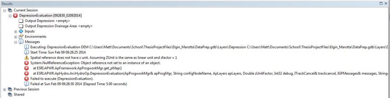
I have attached a screenshot of the error message from the geoprocessing results.
I have tried projecting the raster (in the same co-ordinates) and then altering the projection file to contain appropriate z-values with no luck.
Any input is greatly appreciated!
Thanks,
Matt[ATTACH=CONFIG]31274[/ATTACH]
Solved! Go to Solution.
1 Solution
Accepted Solutions
02-11-2014
01:15 PM
- Mark as New
- Bookmark
- Subscribe
- Mute
- Subscribe to RSS Feed
- Permalink
- Report Inappropriate Content
In case anyone else happens to stumble upon this same error, here's what I did to fix it (thanks to ESRI support!):
- Disable background geoprocessing
- Use a DEM in a grid file format (simply export it out of the GDB) that is located in a root folder (ex. "C:/yourdata/dem")
I'm not sure, however, if it was a combination of both procedures or just the DEM in a grid file format in a root folder. Can't go wrong with both of them though!
3 Replies
02-11-2014
01:15 PM
- Mark as New
- Bookmark
- Subscribe
- Mute
- Subscribe to RSS Feed
- Permalink
- Report Inappropriate Content
In case anyone else happens to stumble upon this same error, here's what I did to fix it (thanks to ESRI support!):
- Disable background geoprocessing
- Use a DEM in a grid file format (simply export it out of the GDB) that is located in a root folder (ex. "C:/yourdata/dem")
I'm not sure, however, if it was a combination of both procedures or just the DEM in a grid file format in a root folder. Can't go wrong with both of them though!
- Disable background geoprocessing
- Use a DEM in a grid file format (simply export it out of the GDB) that is located in a root folder (ex. "C:/yourdata/dem")
I'm not sure, however, if it was a combination of both procedures or just the DEM in a grid file format in a root folder. Can't go wrong with both of them though!
02-14-2014
02:57 AM
- Mark as New
- Bookmark
- Subscribe
- Mute
- Subscribe to RSS Feed
- Permalink
- Report Inappropriate Content
[/HR]
In case anyone else happens to stumble upon this same error, here's what I did to fix it (thanks to ESRI support!):
- Disable background geoprocessing
- Use a DEM in a grid file format (simply export it out of the GDB) that is located in a root folder (ex. "C:/yourdata/dem")
I'm not sure, however, if it was a combination of both procedures or just the DEM in a grid file format in a root folder. Can't go wrong with both of them though!
I got the same error with DEM.tif. I converted it to GRID-format, but that didn't help either. Disabling background geoprocessing did the trick, so I was able to get the processses running, but then at the end the process just stucks or crashes when its calculating depression attributes.
Tested with ArcMap 10.1 and Arc Hydro 10.1 beta.
02-16-2014
03:40 PM
- Mark as New
- Bookmark
- Subscribe
- Mute
- Subscribe to RSS Feed
- Permalink
- Report Inappropriate Content
Stab in the dark here but something else that helped me when I got similar errors with the Depression Evaluation tool:
- rasters should be in GRID format outside of GDB (as noted above), but also:
- features (ie depression and depression drainage area) output to a location within the GDB (not to shapefiles outside of GDB)
- rasters should be in GRID format outside of GDB (as noted above), but also:
- features (ie depression and depression drainage area) output to a location within the GDB (not to shapefiles outside of GDB)