Turn on suggestions
Auto-suggest helps you quickly narrow down your search results by suggesting possible matches as you type.
Cancel
- Home
- :
- All Communities
- :
- Developers
- :
- Python
- :
- Python Questions
- :
- Polygon from GeoJson to Shp conversion arcpy scrip...
Options
- Subscribe to RSS Feed
- Mark Topic as New
- Mark Topic as Read
- Float this Topic for Current User
- Bookmark
- Subscribe
- Mute
- Printer Friendly Page
Polygon from GeoJson to Shp conversion arcpy script is being simplified
Subscribe
01-13-2014
12:51 PM
- Mark as New
- Bookmark
- Subscribe
- Mute
- Subscribe to RSS Feed
- Permalink
- Report Inappropriate Content
I'm trying to make a script that converts the GeoJson format into a shapefile. For the most part, the script in complete, but I'm having an odd issue with the output polygon.
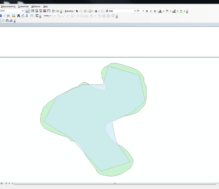
The JSON geometry has a large number of vertices, but ArcMap seem to be GREATLY simplifying the output polygon when arcpy.Polygon(arcpy.Array(point, point, point ...)) happens.
The script I'm using is posted below. Though note, I left out many of the not relevant parts.
The inputs and outputs have been hardcoded for this example, but eventually it will end up as a Python Toolbox
For testing purposes, below is the JSON file I was trying to convert in this example:
Any help is appreciated,
Thanks!
Matt
The JSON geometry has a large number of vertices, but ArcMap seem to be GREATLY simplifying the output polygon when arcpy.Polygon(arcpy.Array(point, point, point ...)) happens.
The script I'm using is posted below. Though note, I left out many of the not relevant parts.
from collections import OrderedDict import arcpy, json, os arcpy.env.overwriteOutput = True def createPolygon(data): """ This function receives a python dictionary representing the JSON array and its geometry type. It will create a feature class of that geometry type and add in the features geometry and attributes (if any). """ # Create feature class and define as WGS84 outFC = arcpy.CreateFeatureclass_management(outLocation,outName,"POLYGON") arcpy.DefineProjection_management(outFC, coordinateSystem) features = data["features"] # Get a list of fields and add them to the feature class fields = [key for key, value in features[0]["properties"].iteritems()] if len(fields) != 0: # dummyField is used because ArcMap requires at least one non-required field. arcpy.AddField_management(outFC,"dummyField","TEXT") arcpy.DeleteField_management(outFC,"Id") for field in fields: arcpy.AddField_management(outFC,field,"TEXT") arcpy.DeleteField_management(outFC,"dummyField") # Create search cursor cursor = arcpy.da.InsertCursor(outFC, ["SHAPE@"] + fields) #Create Arcpy Array to add Polygon verticies too. array = arcpy.Array() # Building Polygon n = 0 for feature in features: n += 1 for geom in feature["geometry"]["coordinates"]: for coords in geom: # Adding verticies to array array.add(arcpy.Point( float(coords[0]), float(coords[1]) )) # Get attributes for insert cursor fields attributes = [attr for key, attr in feature["properties"].iteritems()] # Some debugging prints print len(array) # this reads 150 arcpy.Point objects print arcpy.Polygon(array).pointCount # This only reads 15 points, none of which are the original points. Somehow ArcMap is GREATLY simplifyig this geometry. cursor.insertRow([arcpy.Polygon(array)] + attributes) array.removeAll() del cursor jsonFileName = "inputjsonfile.json" shpOutput = "C:\Path\To\Output\Location\polygon.shp" outLocation = os.path.dirname(shpOutput) outName = os.path.basename(shpOutput) coordinateSystem = arcpy.SpatialReference(4326) with open(jsonFileName,"r") as json_file: data = json.load(json_file, object_pairs_hook=OrderedDict) # Get geometry type geomType = data["features"][0]["geometry"]["type"] if geomType == "Polygon": createPolygon(data)
The inputs and outputs have been hardcoded for this example, but eventually it will end up as a Python Toolbox
For testing purposes, below is the JSON file I was trying to convert in this example:
{"type": "FeatureCollection", "features": [{"type": "Feature", "properties": {"Id": "0", "NAME": "Untitled Polygon", "DESCR": " ", "FOLDER": " "}, "geometry": {"bbox": [-105.6266922454426, 33.309856365277824, -105.61766863755298, 33.31951402483418], "coordinates": [[["-105.623511", "33.317474"], ["-105.623508", "33.317525"], ["-105.623477", "33.317550"], ["-105.623410", "33.317651"], ["-105.623255", "33.317725"], ["-105.623129", "33.317825"], ["-105.623035", "33.317875"], ["-105.622915", "33.317873"], ["-105.622794", "33.317871"], ["-105.622647", "33.317792"], ["-105.622592", "33.317715"], ["-105.622505", "33.317612"], ["-105.622352", "33.317536"], ["-105.622136", "33.317434"], ["-105.622015", "33.317357"], ["-105.621831", "33.317304"], ["-105.621673", "33.317253"], ["-105.621551", "33.317226"], ["-105.621368", "33.317174"], ["-105.621337", "33.317173"], ["-105.621242", "33.317223"], ["-105.621115", "33.317298"], ["-105.621108", "33.317450"], ["-105.621133", "33.317578"], ["-105.621186", "33.317732"], ["-105.621241", "33.317861"], ["-105.621356", "33.318016"], ["-105.621381", "33.318119"], ["-105.621464", "33.318275"], ["-105.621482", "33.318507"], ["-105.621507", "33.318610"], ["-105.621497", "33.318791"], ["-105.621424", "33.318972"], ["-105.621257", "33.319179"], ["-105.621129", "33.319230"], ["-105.620967", "33.319334"], ["-105.620837", "33.319411"], ["-105.620739", "33.319489"], ["-105.620644", "33.319514"], ["-105.620457", "33.319512"], ["-105.620182", "33.319507"], ["-105.619851", "33.319423"], ["-105.619417", "33.319278"], ["-105.619082", "33.319195"], ["-105.618724", "33.319046"], ["-105.618416", "33.318900"], ["-105.618238", "33.318741"], ["-105.618051", "33.318500"], ["-105.617920", "33.318313"], ["-105.617896", "33.318209"], ["-105.617900", "33.318081"], ["-105.617877", "33.317926"], ["-105.617718", "33.317613"], ["-105.617669", "33.317381"], ["-105.617673", "33.317152"], ["-105.617674", "33.316846"], ["-105.617685", "33.316565"], ["-105.617703", "33.316411"], ["-105.617751", "33.316283"], ["-105.617761", "33.316181"], ["-105.617843", "33.315979"], ["-105.617887", "33.315878"], ["-105.617963", "33.315777"], ["-105.618075", "33.315652"], ["-105.618192", "33.315553"], ["-105.618349", "33.315406"], ["-105.618570", "33.315260"], ["-105.618872", "33.315167"], ["-105.619245", "33.315051"], ["-105.619605", "33.314985"], ["-105.619946", "33.314869"], ["-105.620061", "33.314845"], ["-105.620328", "33.314726"], ["-105.620592", "33.314631"], ["-105.620778", "33.314487"], ["-105.621017", "33.314367"], ["-105.621149", "33.314248"], ["-105.621169", "33.314104"], ["-105.621163", "33.313937"], ["-105.621128", "33.313771"], ["-105.621072", "33.313558"], ["-105.620928", "33.313370"], ["-105.620776", "33.313155"], ["-105.620615", "33.312986"], ["-105.620475", "33.312766"], ["-105.620310", "33.312694"], ["-105.620201", "33.312646"], ["-105.620090", "33.312573"], ["-105.619838", "33.312450"], ["-105.619617", "33.312304"], ["-105.619412", "33.312105"], ["-105.619183", "33.311882"], ["-105.619016", "33.311614"], ["-105.618821", "33.311273"], ["-105.618801", "33.311131"], ["-105.618895", "33.310834"], ["-105.619041", "33.310570"], ["-105.619432", "33.310313"], ["-105.619758", "33.310103"], ["-105.620176", "33.309952"], ["-105.620624", "33.309856"], ["-105.621002", "33.309897"], ["-105.621464", "33.309992"], ["-105.621709", "33.310086"], ["-105.621857", "33.310213"], ["-105.621952", "33.310367"], ["-105.621971", "33.310478"], ["-105.622093", "33.310607"], ["-105.622246", "33.310834"], ["-105.622495", "33.311170"], ["-105.622773", "33.311533"], ["-105.622925", "33.311762"], ["-105.623194", "33.312341"], ["-105.623289", "33.312598"], ["-105.623422", "33.312690"], ["-105.623501", "33.312759"], ["-105.623716", "33.312825"], ["-105.623853", "33.312845"], ["-105.623964", "33.312868"], ["-105.624024", "33.312869"], ["-105.624166", "33.312943"], ["-105.624244", "33.313062"], ["-105.624417", "33.313212"], ["-105.624569", "33.313244"], ["-105.624833", "33.313324"], ["-105.625213", "33.313455"], ["-105.625559", "33.313582"], ["-105.625844", "33.313705"], ["-105.625987", "33.313779"], ["-105.626188", "33.313878"], ["-105.626360", "33.313976"], ["-105.626472", "33.314123"], ["-105.626612", "33.314319"], ["-105.626692", "33.314538"], ["-105.626684", "33.314782"], ["-105.626677", "33.315003"], ["-105.626641", "33.315224"], ["-105.626548", "33.315396"], ["-105.626513", "33.315569"], ["-105.626420", "33.315741"], ["-105.625983", "33.316182"], ["-105.625570", "33.316456"], ["-105.625347", "33.316607"], ["-105.625094", "33.316757"], ["-105.624817", "33.316904"], ["-105.624307", "33.317195"], ["-105.624008", "33.317363"], ["-105.623802", "33.317433"], ["-105.623655", "33.317479"], ["-105.623511", "33.317474"]]], "type": "Polygon"}}]}Any help is appreciated,
Thanks!
Matt
Solved! Go to Solution.
1 Solution
Accepted Solutions
01-13-2014
02:04 PM
- Mark as New
- Bookmark
- Subscribe
- Mute
- Subscribe to RSS Feed
- Permalink
- Report Inappropriate Content
Hi Matt,
If you specify the coordinate system when creating the polygons (lines 51 and 53 of your original code) it appears to work...
Let me know how you get on.
Stacy
If you specify the coordinate system when creating the polygons (lines 51 and 53 of your original code) it appears to work...
print arcpy.Polygon(array, coordinateSystem).pointCount cursor.insertRow([arcpy.Polygon(array, coordinateSystem)] + attributes)
Let me know how you get on.
Stacy
2 Replies
01-13-2014
02:04 PM
- Mark as New
- Bookmark
- Subscribe
- Mute
- Subscribe to RSS Feed
- Permalink
- Report Inappropriate Content
Hi Matt,
If you specify the coordinate system when creating the polygons (lines 51 and 53 of your original code) it appears to work...
Let me know how you get on.
Stacy
If you specify the coordinate system when creating the polygons (lines 51 and 53 of your original code) it appears to work...
print arcpy.Polygon(array, coordinateSystem).pointCount cursor.insertRow([arcpy.Polygon(array, coordinateSystem)] + attributes)
Let me know how you get on.
Stacy
01-13-2014
02:11 PM
- Mark as New
- Bookmark
- Subscribe
- Mute
- Subscribe to RSS Feed
- Permalink
- Report Inappropriate Content
That did it!
I didn't see the inputs for the Polygon object:
Polygon (inputs, {spatial_reference}, {has_z}, {has_m})
Putting the spatial reference in there worked like a charm,
Thanks very much!
I didn't see the inputs for the Polygon object:
Polygon (inputs, {spatial_reference}, {has_z}, {has_m})
Putting the spatial reference in there worked like a charm,
Thanks very much!