Turn on suggestions
Auto-suggest helps you quickly narrow down your search results by suggesting possible matches as you type.
Cancel
- Home
- :
- All Communities
- :
- Products
- :
- ArcGIS Spatial Analyst
- :
- ArcGIS Spatial Analyst Questions
- :
- Incorrect Results from Line Density Tool
Options
- Subscribe to RSS Feed
- Mark Topic as New
- Mark Topic as Read
- Float this Topic for Current User
- Bookmark
- Subscribe
- Mute
- Printer Friendly Page
Incorrect Results from Line Density Tool
Subscribe
2760
1
09-04-2013 01:58 PM
09-04-2013
01:58 PM
- Mark as New
- Bookmark
- Subscribe
- Mute
- Subscribe to RSS Feed
- Permalink
- Report Inappropriate Content
Hello,
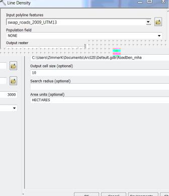
I am trying create a raster that shows road density (m/ha) within 3km radius of the cell. The line density tool in Spatial Analyst appears to be the tool to do this as it allows for input of a line file (roads), a search radius (3000m), output raster cell size (10m), and area unit (ha). However, upon running the tool I getting results that I don't believe to be correct. For example the maximum value I am getting is 0.27 m/ha, which is way to low of a value considering to the high road density in the area. To double check I converted a portion of the raster to points and buffered those points by 3 km and found the area of road within this buffer. Using this information the road density values come out to around 9 or 10 m/ha which is much more reasonable for the density of roads in the area. The dataframe and road layer is in UTM Zone 12N so the units should be in meters. Any ideas why these results are not correct? I wonder if it has to do with the population field being set to none as in the tool help it indicates the population field is a:
Numeric field denoting population values (the number of times the line should be counted) for each polyline.
Values in the population field may be integer or floating point.
The options and default behaviours for the field are listed below.
Use None if no item or special value will be used and each feature will be counted once.
Therefore I'm wondering if it is only counting each road line feature the first time it intersects a cell search radius instead of counting it within the search radius of each cell.
Any advice or suggestions would be greatly appreciated. Below is my inputs if that helps. Thanks in advance.
1 Reply
09-05-2013
01:31 AM
- Mark as New
- Bookmark
- Subscribe
- Mute
- Subscribe to RSS Feed
- Permalink
- Report Inappropriate Content
Hello,
I am trying create a raster that shows road density (m/ha) within 3km radius of the cell. The line density tool in Spatial Analyst appears to be the tool to do this as it allows for input of a line file (roads), a search radius (3000m), output raster cell size (10m), and area unit (ha). However, upon running the tool I getting results that I don't believe to be correct. For example the maximum value I am getting is 0.27 m/ha, which is way to low of a value considering to the high road density in the area. To double check I converted a portion of the raster to points and buffered those points by 3 km and found the area of road within this buffer. Using this information the road density values come out to around 9 or 10 m/ha which is much more reasonable for the density of roads in the area. The dataframe and road layer is in UTM Zone 12N so the units should be in meters. Any ideas why these results are not correct? I wonder if it has to do with the population field being set to none as in the tool help it indicates the population field is a:
Numeric field denoting population values (the number of times the line should be counted) for each polyline.
Values in the population field may be integer or floating point.
The options and default behaviours for the field are listed below.
Use None if no item or special value will be used and each feature will be counted once.
Therefore I'm wondering if it is only counting each road line feature the first time it intersects a cell search radius instead of counting it within the search radius of each cell.
Any advice or suggestions would be greatly appreciated. Below is my inputs if that helps. Thanks in advance.
Hi Karl,
If you look at the explanation in the Help you will see that the density is calculated as follows:
Density = ((L1 * V1) + (L2 * V2)) / (area_of_circle)
Lines L1 and L2 represent the length of the portion of each line that falls within the circle. The corresponding population field values are V1 and V2.
Source: http://resources.arcgis.com/en/help/main/10.2/index.html#//009z00000012000000
In your case, you are not applying a population field, so it is reduced to:
Density = (L1 + L2) / (area_of_circle)
Since you are using a search radius of 3000m, the area of the circle is ± 28274333m² (or 2827ha or 28.27km²). This causes the density to result in very low values.
In Help you will also find this:
A default area unit is selected based on the linear unit of the projection definition of the input polyline feature data or as otherwise specified in the output coordinate system environment setting. For line density, when an area unit factor is specified, it converts the units of both length and area.
For example, if the linear unit is meters, the output area units will default to SQUARE_KILOMETERS and the resulting line density units will convert to kilometers per square kilometer. The end result, comparing an area scale factor of meters to kilometers, will be the density values being different by a multiplier of 1,000. (... so not 1,000,000)
Hope this helps you to interpret the results, although it may not be what you are looking for...
Kind regards,
Xander