Turn on suggestions
Auto-suggest helps you quickly narrow down your search results by suggesting possible matches as you type.
Cancel
- Home
- :
- All Communities
- :
- Products
- :
- Geoprocessing
- :
- Geoprocessing Questions
- :
- Network Analyst in geo processing service
Options
- Subscribe to RSS Feed
- Mark Topic as New
- Mark Topic as Read
- Float this Topic for Current User
- Bookmark
- Subscribe
- Mute
- Printer Friendly Page
Network Analyst in geo processing service
Subscribe
561
0
07-03-2013 12:39 PM
07-03-2013
12:39 PM
- Mark as New
- Bookmark
- Subscribe
- Mute
- Subscribe to RSS Feed
- Permalink
- Report Inappropriate Content
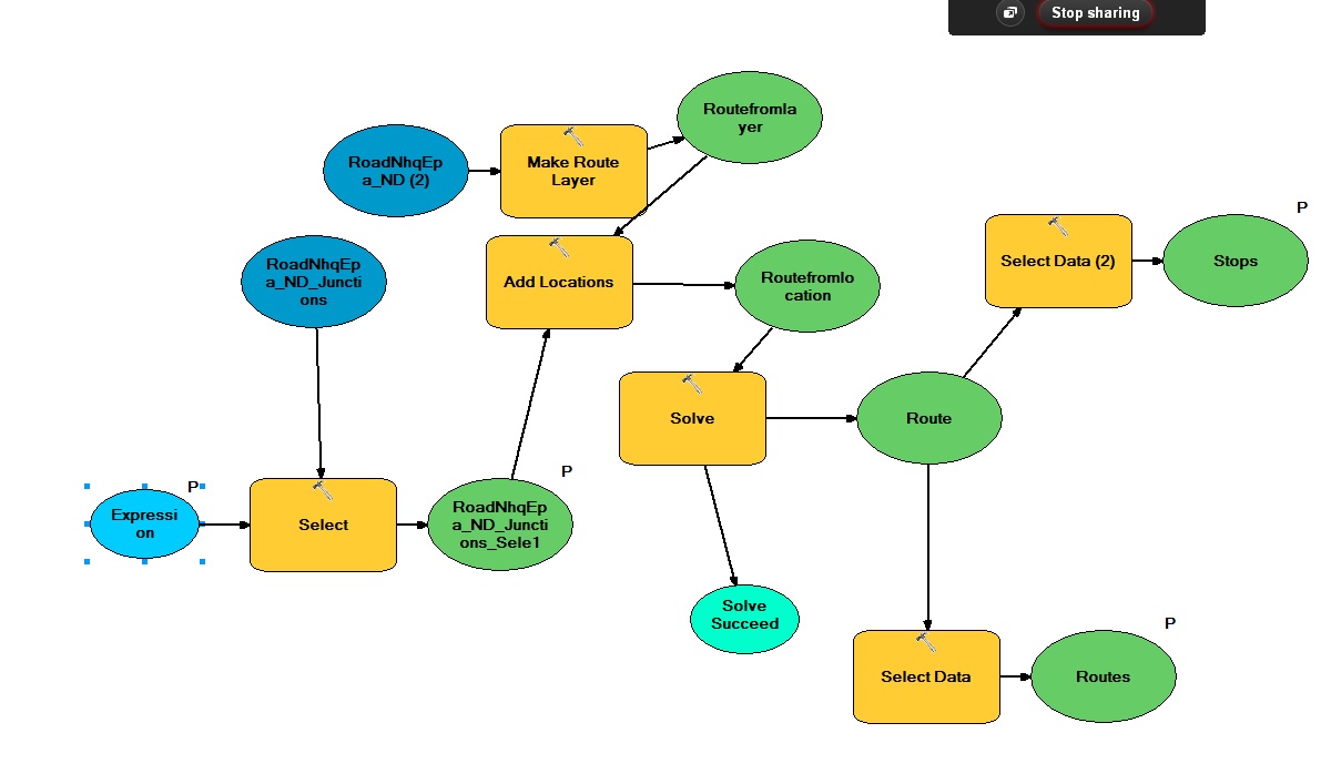
I have used network analyst tool box as can be seen in attached model. This model is working fine. when i run it under ArcMAp it gives me routes and stop and also draws routes between two given point. I published it as synchronous geoprocessing service and accessed it in flex application. I provide the required parameter and execute the task using execute method. it returns me the length of the route. however i also want to draw the route between two points in my flex application. Please see the attached model and below is the geoprocessing detail. Now is there any suggestion how i can draw the route in my flex application:
thanks.
code that I using in the flex web application to read the route length is :
private function SolveRoutes_Complete(event:GeoprocessorEvent):void
{
parameterValue = event.executeResult.results[0];
fset = FeatureSet(parameterValue.value);
for each ( var myfset:Graphic in fset.features) //event.parameterValues[0].value.features )
{
Alert.show("Rname"+ myfset.attributes.RouteName + "Clength"+ myfset.attributes.Cumul_Length);
}
}
Detail of Geoprocessing service:
Execution Type: esriExecutionTypeSynchronous
Parameters:
Parameter: Expression
Data Type: GPString
Display Name Expression
Direction: esriGPParameterDirectionInput
Default Value: ObjectID= 82949 or ObjectID =78012
Parameter Type: esriGPParameterTypeOptional
Category:
Parameter: Stops
Data Type: GPFeatureRecordSetLayer
Display Name Stops
Direction: esriGPParameterDirectionOutput
Default Value:
Geometry Type: esriGeometryPoint
HasZ: true
HasM: false
Spatial Reference: 29900 (29902)
Fields:
OBJECTID ( type: esriFieldTypeOID , alias: OBJECTID )
Name ( type: esriFieldTypeString , alias: Name , length: 128 )
RouteName ( type: esriFieldTypeString , alias: RouteName , length: 128 )
Sequence ( type: esriFieldTypeInteger , alias: Sequence )
TimeWindowStart ( type: esriFieldTypeDate , alias: TimeWindowStart , length: 8 )
TimeWindowEnd ( type: esriFieldTypeDate , alias: TimeWindowEnd , length: 8 )
ArriveCurbApproach ( type: esriFieldTypeInteger , alias: ArriveCurbApproach )
DepartCurbApproach ( type: esriFieldTypeInteger , alias: DepartCurbApproach )
SourceID ( type: esriFieldTypeInteger , alias: SourceID )
SourceOID ( type: esriFieldTypeInteger , alias: SourceOID )
PosAlong ( type: esriFieldTypeDouble , alias: PosAlong )
SideOfEdge ( type: esriFieldTypeInteger , alias: SideOfEdge )
CurbApproach ( type: esriFieldTypeInteger , alias: CurbApproach )
Status ( type: esriFieldTypeInteger , alias: Status )
Attr_Length ( type: esriFieldTypeDouble , alias: Attr_Length )
Cumul_Length ( type: esriFieldTypeDouble , alias: Cumul_Length )
Features: None.
Parameter Type: esriGPParameterTypeDerived
Category:
Parameter: Routes
Data Type: GPFeatureRecordSetLayer
Display Name Routes
Direction: esriGPParameterDirectionOutput
Default Value:
Geometry Type: esriGeometryPolyline
HasZ: true
HasM: true
Spatial Reference: 29900 (29902)
Fields:
OBJECTID ( type: esriFieldTypeOID , alias: OBJECTID )
Name ( type: esriFieldTypeString , alias: Name , length: 128 )
FirstStopID ( type: esriFieldTypeInteger , alias: FirstStopID )
LastStopID ( type: esriFieldTypeInteger , alias: LastStopID )
StopCount ( type: esriFieldTypeInteger , alias: StopCount )
Total_Length ( type: esriFieldTypeDouble , alias: Total_Length )
Shape_Length ( type: esriFieldTypeDouble , alias: Shape_Length )
Features: None.
Parameter Type: esriGPParameterTypeDerived
Category:
0 Replies