Turn on suggestions
Auto-suggest helps you quickly narrow down your search results by suggesting possible matches as you type.
Cancel
- Home
- :
- All Communities
- :
- Products
- :
- ArcGIS Network Analyst
- :
- ArcGIS Network Analyst Questions
- :
- Executing network analyst task
Options
- Subscribe to RSS Feed
- Mark Topic as New
- Mark Topic as Read
- Float this Topic for Current User
- Bookmark
- Subscribe
- Mute
- Printer Friendly Page
Executing network analyst task
Subscribe
2796
6
12-25-2012 11:08 PM
12-25-2012
11:08 PM
- Mark as New
- Bookmark
- Subscribe
- Mute
- Subscribe to RSS Feed
- Permalink
- Report Inappropriate Content
Hi,
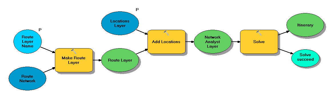
I have created a network analyst task (find route with specified stops), by the model builder tool.
When I execute the task nothing happens and in the output window I get the success message:
Here is a screenshot of the model I created:
[ATTACH=CONFIG]20194[/ATTACH]
Do you have any explanation to that?
Regards.
6 Replies
12-26-2012
02:03 PM
- Mark as New
- Bookmark
- Subscribe
- Mute
- Subscribe to RSS Feed
- Permalink
- Report Inappropriate Content
Make the results of the Solve be a model parameter. Read more here on how to display the results of a model.
http://resources.arcgis.com/en/help/main/10.1/#/Displaying_model_data/002w0000003q000000/
Jay Sandhu
http://resources.arcgis.com/en/help/main/10.1/#/Displaying_model_data/002w0000003q000000/
Jay Sandhu
12-26-2012
10:48 PM
- Mark as New
- Bookmark
- Subscribe
- Mute
- Subscribe to RSS Feed
- Permalink
- Report Inappropriate Content
Nop!
It seems that the display of the route layer in the output is completely arbitrary. Sometimes it works, sometimes it doesn't. Maybe it's another bug in the unstable model builder!
Both Add to Display and Model Parameter are checked for the output of the solve operation, and still, the route result isn't displayed on the map.
I don't know where it hides!
12-27-2012
12:41 PM
- Mark as New
- Bookmark
- Subscribe
- Mute
- Subscribe to RSS Feed
- Permalink
- Report Inappropriate Content
Make the results of the Solve be a model parameter. Read more here on how to display the results of a model.
http://resources.arcgis.com/en/help/main/10.1/#/Displaying_model_data/002w0000003q000000/
Jay Sandhu
I'm also interested in displaying the results form a network Solve in either a AGO map or a web app. Haven't been successful in either platform. I've put together a python script tool and published as a GP tool for use in a Flex app. It runs and generates a solve layer and directions text file on the ArcGIS Server. How might I leverage this into AGO?
12-27-2012
01:58 PM
- Mark as New
- Bookmark
- Subscribe
- Mute
- Subscribe to RSS Feed
- Permalink
- Report Inappropriate Content
One other thing you can make sure to check is in the ArcMap top menu, click on Geoprocessing and select Geoprocessing options and make sure that the "Add results of geoprocessing operations to the display" is also checked on.
Jay Sandhu
Jay Sandhu
12-28-2012
04:32 AM
- Mark as New
- Bookmark
- Subscribe
- Mute
- Subscribe to RSS Feed
- Permalink
- Report Inappropriate Content
Hi, you might also try to go through the step-by-step tutorial on publishing a GP service with (10.1 though):
Geoprocessing service example: Shortest route on a street network
It gives you the output layer with the route as well as directions in the specified format (.html, .xml, .txt).
The GP services that are based on 10.1 Network Analyst core GP tools work fine and I've been using them almost daily recently.
12-28-2012
05:05 AM
- Mark as New
- Bookmark
- Subscribe
- Mute
- Subscribe to RSS Feed
- Permalink
- Report Inappropriate Content
Thanks for the suggestions. I'm able to display the results from the script tool in ArcMap, but no such luck with getting results to display via a geoprocessing service in a flex app. Apparently it's a bug with the Flex api. Now I'm wondering how I might be able to leverage and use a network data set in ArcGIS Online. Any suggestions or ideas?