- Home
- :
- All Communities
- :
- User Groups
- :
- Web AppBuilder Custom Widgets
- :
- Documents
- :
- ImportFile.zip
- Subscribe to RSS Feed
- Mark as New
- Mark as Read
- Bookmark
- Subscribe
- Printer Friendly Page
- Report Inappropriate Content
ImportFile.zip
ImportFile.zip
Hi all,
We decided to share a widget we had developed with the community.
Development credits: Walter Payne
Import file widget:
Allows users to add a SHP, CSV OR DXF to directly to a Web App and specify a coordinate system.
To modify the coordinate system edit both ArcMap Toolbox parameters and the .py file.
The widget requires the enhanced layer list widget to display the results.
Regards
Adam
- Mark as Read
- Mark as New
- Bookmark
- Permalink
- Report Inappropriate Content
Hi Adam,
Thanks for sharing this. This sounds very useful. Do you have a sample web application with this widget loaded that we can look at?
There is an "idea" out there for this very thing:
https://community.esri.com/ideas/12084
It sounds like your widget is the solution!
- Mark as Read
- Mark as New
- Bookmark
- Permalink
- Report Inappropriate Content
Nothing hosted externally unfortunately.
- Mark as Read
- Mark as New
- Bookmark
- Permalink
- Report Inappropriate Content
Adam,
I've gotten your widget to work almost all the way, except for the "display results" part. I do not have the javascript version of the Enhanced Layer List Widget, which you state is necessary to make this happen. Do you (or anyone else reading this) have a link to that widget? I've looked everywhere that I know of.
Thanks.
- Mark as Read
- Mark as New
- Bookmark
- Permalink
- Report Inappropriate Content
Daniel,
try configuring the geoprocessing tool to be 'synchronous', message level to 'info'.
I'll update the instructions.
Thanks,
Walter
- Mark as Read
- Mark as New
- Bookmark
- Permalink
- Report Inappropriate Content
Adam,
Where can we find the "Enhanced Layer List" widget that is required? Searches haven't yielded anything.
Thanks,
Eric
- Mark as Read
- Mark as New
- Bookmark
- Permalink
- Report Inappropriate Content
Walter - thanks! I appreciate the guidance. Once I changed the properties of the published GP tool as you instructed, the points showed up on the map.
To be safe I downloaded the most recent zip file, copied everything over (replacing original files), restarted WAB, and then removed and reinstalled the widget in WAB. While the widget does work, I initially get a popup that says "File upload success" and the immediately after that I get "No File Selected" ...but it doesn't seem to affect anything.
Note that I still do not have an "Enhanced Layer List" widget for WAB, but the points do show up despite this. I do have the OOTB "Layer List" widget going, and the CSV is in there (see the screencap attachment):
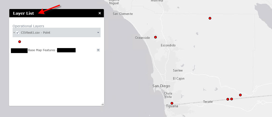
However, there doesn't seem to be a way to remove the csv/points once they have been added to the map and import file widget Any chance that feature may be added? The ability to label the points would be great as well.
Thanks again
- Mark as Read
- Mark as New
- Bookmark
- Permalink
- Report Inappropriate Content
Project created on github for this here: GitHub - vaughnmuirhead/import-file: A custom widget for ESRI's web appbuilder product that allows a...
- Mark as Read
- Mark as New
- Bookmark
- Permalink
- Report Inappropriate Content
Hi,
How can I change the coordinate system?
- Mark as Read
- Mark as New
- Bookmark
- Permalink
- Report Inappropriate Content
Hello! we cant drag ZIP files into de WAB, all the code is OK but we arent be able. CSV is OK, but we cant process the ZIP files, it dont matter about the lenght of the name, the features that u're trying to process or something similar. Nothing appears when you upload a ZIP file into de widget....some help?¿? PLZZZZZZZZZZZZZZZZZZZZZZZZZZ
- Mark as Read
- Mark as New
- Bookmark
- Permalink
- Report Inappropriate Content
Has there been any further development on configuring this WAB drag & drop tool? All I have been able to do is run the GP tool but naturally it won't display any results because I need to be able to change the coordinate system to see the results; hence, there is nothing to publish.
I'm using ArcGIS 10.6.1, and have just upgraded Portal and GIS Server to 10.6.1 as well. I'm also using ArcGIS Pro 2.2, but I'm not sure yet if this tool will work in ArcGIS Pro (I need to get it working in ArcMap first  ).
).
It would be useful if we could all learn:
1) What needs to be updated to make this work (i.e. Python script? JSON script? If so, which ones?)?
2) How do you edit the projection choices in the ImportFile tool?
3) If the results do not appear in the ArcMap TOC and Data Frame, then where do the results end up?
4) Has anyone seen a more detailed "step-by-step" explanation on how to configure this tool properly?
Would love to demonstrate this during our GIS Day presentation on November 14th (2018).
Thanks