- Home
- :
- All Communities
- :
- User Groups
- :
- Web AppBuilder Custom Widgets
- :
- Documents
- :
- Enhanced Search Widget Version 2.23.1 - 11/22/22
- Subscribe to RSS Feed
- Mark as New
- Mark as Read
- Bookmark
- Subscribe
- Printer Friendly Page
- Report Inappropriate Content
Enhanced Search Widget Version 2.23.1 - 11/22/22
Enhanced Search Widget Version 2.23.1 - 11/22/22
Web AppBuilder for ArcGIS | Help - Enhanced Search widget
List of the latest enhancements and changes:
- Fixed issue with Spatial Relationship settings
Older enhancements or changes
Check the "Older enhancements or changes.txt" in the download for a complete list.
Older Versions
- Mark as Read
- Mark as New
- Bookmark
- Permalink
- Report Inappropriate Content
Michael,
If you want the buffer to appear in the print then go to the "Edit default buffer properties" and choose "Add the buffer layer to the maps legend"
Is it possible to have it create a buffer graphic without selecting any features if a user just wants to show a buffered area?
No.
- Mark as Read
- Mark as New
- Bookmark
- Permalink
- Report Inappropriate Content
Lara,
You have some strange stuff going on in your SQL statement. Pleas start a new thread so you can attach your config_Enhanced Search.json
https://community.esri.com/discussion/create.jspa?containerType=700&containerID=1294
- Mark as Read
- Mark as New
- Bookmark
- Permalink
- Report Inappropriate Content
Suzy,
Looks like I have issues in the widgets querying hosted services by date. I will have this fixed in the 1.2.0.5 release.
- Mark as Read
- Mark as New
- Bookmark
- Permalink
- Report Inappropriate Content
Thanks for the quick reply – it’s good to know that it is my data and not me. We’ve posted the hosted service as a proof of concept while we are doing the data development for the version that will become the mapservice. I’m guessing that if I were working with a mapservice, I may not have encountered the issues? The shape query I can get to work, I have struggled with most of the value queries that I have tried to build.
I’m going to set this work aside knowing that it won’t work with the combination of data and widgets that I currently have available. I hope to have a mapservice by the end of the week and will pick with using version 1.2.0.4 then.
Thanks again for being so responsive.
Suzy Brunzell
O: 206.684.7961
- Mark as Read
- Mark as New
- Bookmark
- Permalink
- Report Inappropriate Content
Suzy,
I’m guessing that if I were working with a mapservice, I may not have encountered the issues?
Correct
I have struggled with most of the value queries that I have tried to build.
Let me know if you need help here.
- Mark as Read
- Mark as New
- Bookmark
- Permalink
- Report Inappropriate Content
Thanks Robert – I think that I will wait until I have a mapservice to work with.
Suzy Brunzell
O: 206.684.7961
- Mark as Read
- Mark as New
- Bookmark
- Permalink
- Report Inappropriate Content
If you want the buffer to appear in the print then go to the "Edit default buffer properties" and choose "Add the buffer layer to the maps legend"
Okay thanks. I tried that but found the buffer graphic was still turning off when the eSearch widget is closed but now I see that if I open the layer list and turn off the buffer graphic an then turn it on again, it will stay then on.
- Mark as Read
- Mark as New
- Bookmark
- Permalink
- Report Inappropriate Content
Michael,
That was fixed in 1.2.0.4 released today(10/13/15).
- Mark as Read
- Mark as New
- Bookmark
- Permalink
- Report Inappropriate Content
Robert,
After last nights (10/13/2015) Microsoft updates, i seem to have lost all my ESearch attribute queries for some reason. I have WAB 1.2 installed on 2 machines, with the same Main GIS app installed and also a copy on my web server, and they're missing from all of them. The only thing I can think of that happened to all of them are the critical updates.. Have you seen this behavior? I just wanted to check with you before I did anything drastic..
thanks again for your work. i believe the ESearch versions were all 1.2.0.3
Gerald
Here's my main app
- Mark as Read
- Mark as New
- Bookmark
- Permalink
- Report Inappropriate Content
Gerald,
You seem to have an issue with this service: Planning/SUBDIVISIONS/MapServer it is returning error 500.
- Mark as Read
- Mark as New
- Bookmark
- Permalink
- Report Inappropriate Content
Hi Robert,
I downloaded widget yesterday and seems to be working great except for one part. For some reason the URL parameter search isn't working. I have it checked on in the UI but it won't show up in the "Results" tab. Also when I try a search using URL parameters I get an error asking for a value even though the value is in the URL (link for reference). Is there a common thing I'm missing or did something change with the most recent update?
Thanks for all your work on this, I wish ESRI took as much initiative as you!!
Thanks,
Levi
- Mark as Read
- Mark as New
- Bookmark
- Permalink
- Report Inappropriate Content
Yes Sir, once again- Bingo !. That was it. Wow. i just visually checked it and it appeared working but i just republished it and now all the other layer queries are working correctly. i wouldve thought just that subdivision query should have been greyed out and the others still work.
Guess its all or nothing with queries..
Anyway, thanks again Robert.
Gerald
- Mark as Read
- Mark as New
- Bookmark
- Permalink
- Report Inappropriate Content
Gerald,
Ya, I need to re-evaluate that portion of code to handle layer failures individually.
- Mark as Read
- Mark as New
- Bookmark
- Permalink
- Report Inappropriate Content
Levi,
Thanks for bringing this to my attention. I will look into the issue but it is most likely to do with my new required expression value feature.
- Mark as Read
- Mark as New
- Bookmark
- Permalink
- Report Inappropriate Content
I found the issue to be that the url search was not populating the text box and thus was firing the required field warning. I have fixed this in the 1.2.0.5 version and it will be available latter this week.
- Mark as Read
- Mark as New
- Bookmark
- Permalink
- Report Inappropriate Content
Hi,
I love the widget - it has been extremely useful. I just wondered if there was a way to allow users to manually search by a coordinate? I know there is the Enhanced Locate Widget, but our users often need to search and return results by a precise (BNG) coordinate.
Thanks,
Helen
- Mark as Read
- Mark as New
- Bookmark
- Permalink
- Report Inappropriate Content
Helen,
The eLocate and eSearch are integrated to work together now in version 1.2.0.4. I do not have any plans to add coordinate search ability into the eSearch. The eSearch is already a extremely complex widget.
- Mark as Read
- Mark as New
- Bookmark
- Permalink
- Report Inappropriate Content
Thanks for the new version Robert. Particularly the third fix.
Lara
- Mark as Read
- Mark as New
- Bookmark
- Permalink
- Report Inappropriate Content
Hey Robert,
Thanks for the update. Seems to be working like a champ now!
Levi
- Mark as Read
- Mark as New
- Bookmark
- Permalink
- Report Inappropriate Content
Hey Robert,
First off this widget is amazing. Thank you for all your hard work.
Any clue on why the layer symbology from server would not translate through? I have a layer with specific symbology that isn't being applied when the esearch is performed.
Thanks again!
- Mark as Read
- Mark as New
- Bookmark
- Permalink
- Report Inappropriate Content
Kelly,
Any clue on why the layer symbology from server would not translate through? I have a layer with specific symbology that isn't being applied when the esearch is performed.
Are you using any advanced cartographic symbology that is not supported by ArcGIS Server?
Are there any plans to be able to do multiple statement expression queries? For example I want people to be able to search by both a permit date range and the hole direction.
Already supported, just add a second expression.
- Mark as Read
- Mark as New
- Bookmark
- Permalink
- Report Inappropriate Content
I actually just figured it out...go figure right after I post a question. I had the layers filtered by hole direction, as soon as added that as a requirement into my expression the symbology came through. Works beautiful now. My users are going to be thrilled with this!
- Mark as Read
- Mark as New
- Bookmark
- Permalink
- Report Inappropriate Content
All,
I am looking for some feedback as to where to focus development efforts for the eSearch next.
Things I am considering:
- Adding stand alone table search support.
- Adding time to date searches.
I don't want to spend valuable development time right now on nice to have things I am looking for "We really need!"
- Mark as Read
- Mark as New
- Bookmark
- Permalink
- Report Inappropriate Content
Hi Robert,
Your plan sounds perfect to me. You have already added the core essentials I needed the most to migrate our Flex Apps to your JavaScript version of your Enhanced Search Widget.
Having the added functionality of performing Table Searches, and being able to do a search based on
Time will be the icing on the cake.
I like all the enhancements you have included in version 1.2.0.4, and I am testing them out against the 6 Themes. Looks wonderful so far!
- Mark as Read
- Mark as New
- Bookmark
- Permalink
- Report Inappropriate Content
Tapas,
Don't forget that 1.2.0.5 came out this week too.
- Mark as Read
- Mark as New
- Bookmark
- Permalink
- Report Inappropriate Content
Robert,
Yes, I see that you posted version 1.2.0.5 yesterday.
You are faster than the wind!
I like how you can now Add and Delete features to the Selection Set.
This is an amazingly powerful widget.
I have no clue how you have got all your complex code to work.
I will be posting my test results on the 6 Themes using:
Enhanced Search Widget 1.2.0.5
Identify Widget 1.2.0.2
Enhanced Locate 1.2.0.1
I like how the output of the Enhanced Locate widget can be used as an input to the Enhanced Search Widget.
This is simply brilliant!!
- Mark as Read
- Mark as New
- Bookmark
- Permalink
- Report Inappropriate Content
Stand alone table searches would be really powerful
-David
- Mark as Read
- Mark as New
- Bookmark
- Permalink
- Report Inappropriate Content
Hi Robert,
Once again, you have done a spectacular job with your new enhancements to the Enhanced Search Widget and the Enhanced Locate Widget.
I tested 8 of your Custom Widgets for the Developer Edition of the Web AppBuilder 1.2.
Enhanced Search 1.2.0.5
Enhanced Locate 1.2.0.1
Identify 1.2.0.2
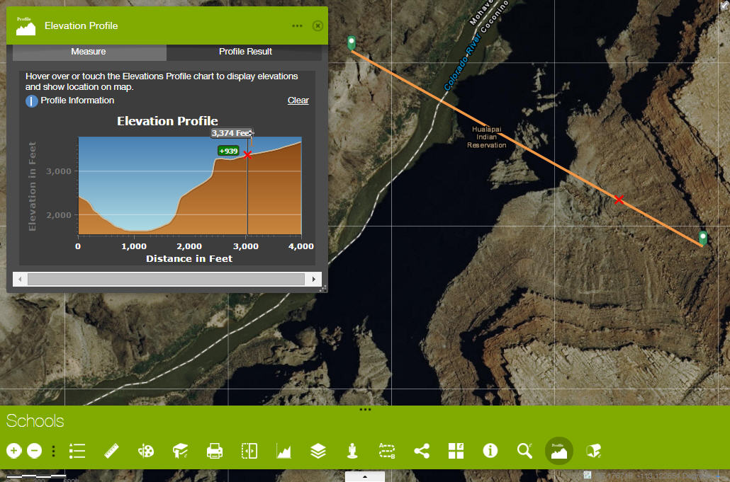
Elevation Profile 1.2
Enhanced Basemap Gallery Beta 1.1
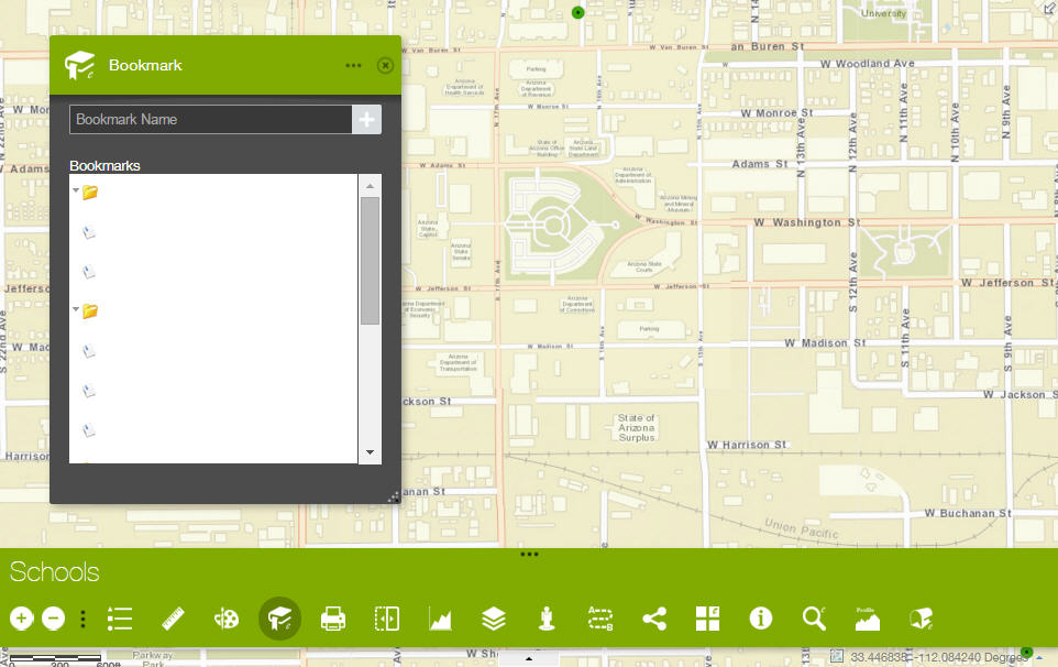
Enhanced Bookmark 1.2
Google Street View 1.2
Share 1.2.0.1
Foldable Theme
http://www.tapasdas.com/Maps/Phones/app76/
This is the most versatile theme, and gracefully folds to work on a smartphone.
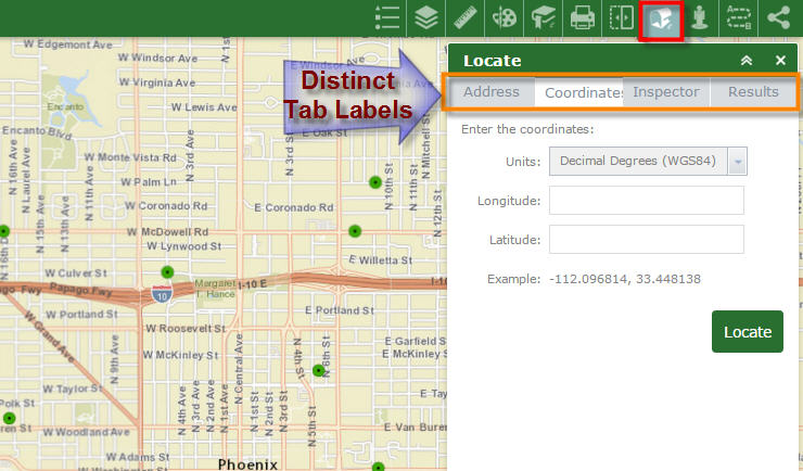
I like that the Tab Labels are now distinct on the Enhanced Locate Widget.
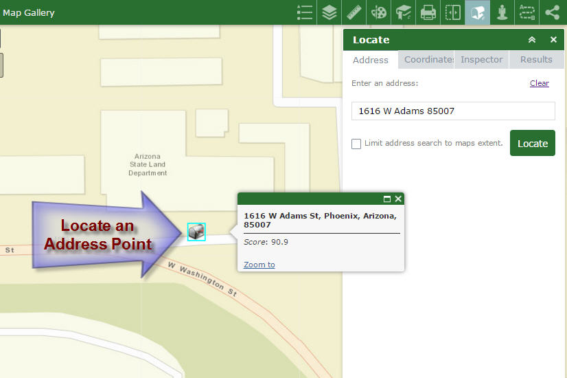
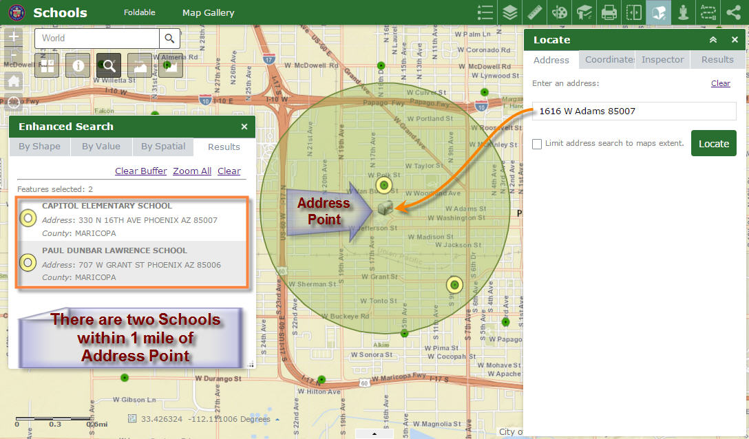
I like how you can locate an Address Point based on a partial entry, and it returns all the possible choices.
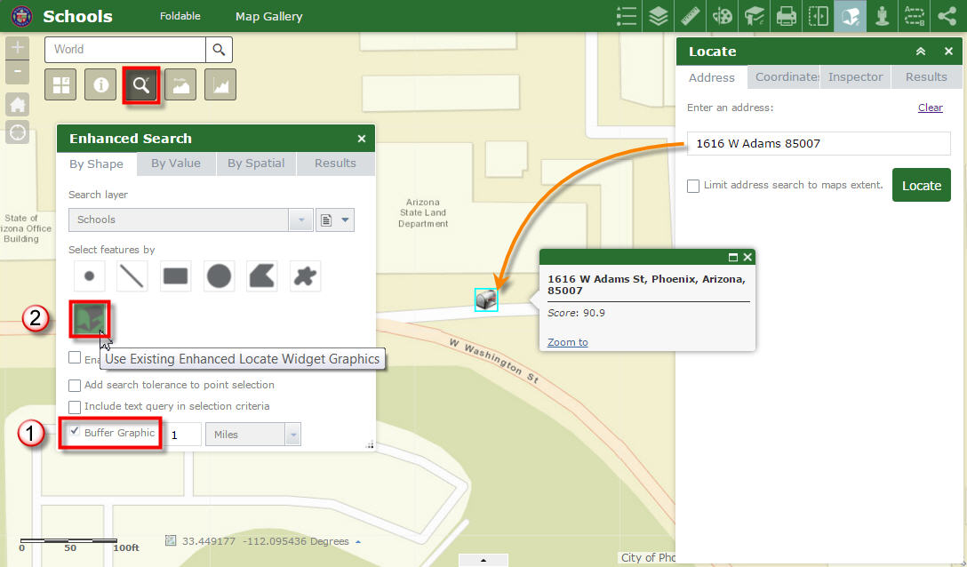
What I really like is how the output of the Enhanced Locate Widget can be used as an input to the Enhanced Search Widget.
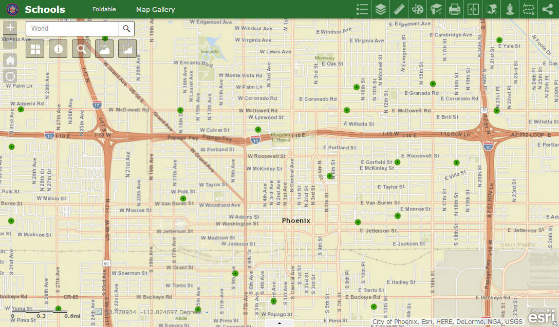
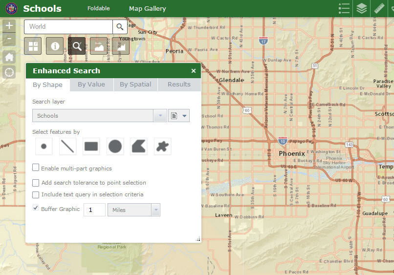
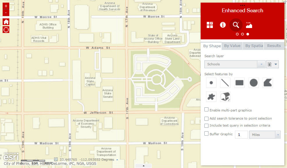
This makes it very easy to find all the Schools within 1 mile of your Address Point with two mouse clicks:
- Check the Buffer Graphic option (default is 1 mile).
- Click on the Use Existing Enhanced Locate Widget Graphics tool.
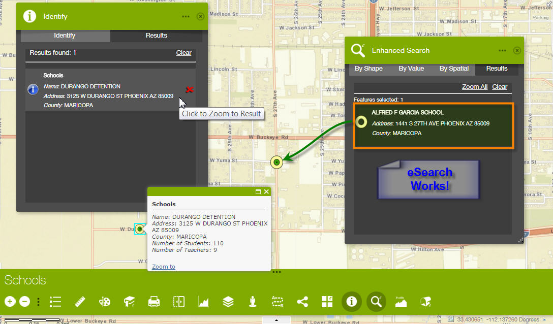
There are two Schools within 1 mile of my Address Point.
This is the cleanest implementation for answering the most common question - search for the entities within 1 mile of my location.
The user can proceed to run a Spatial Search to find all the ZIP Codes that are intersected by this 1 mile Buffer.
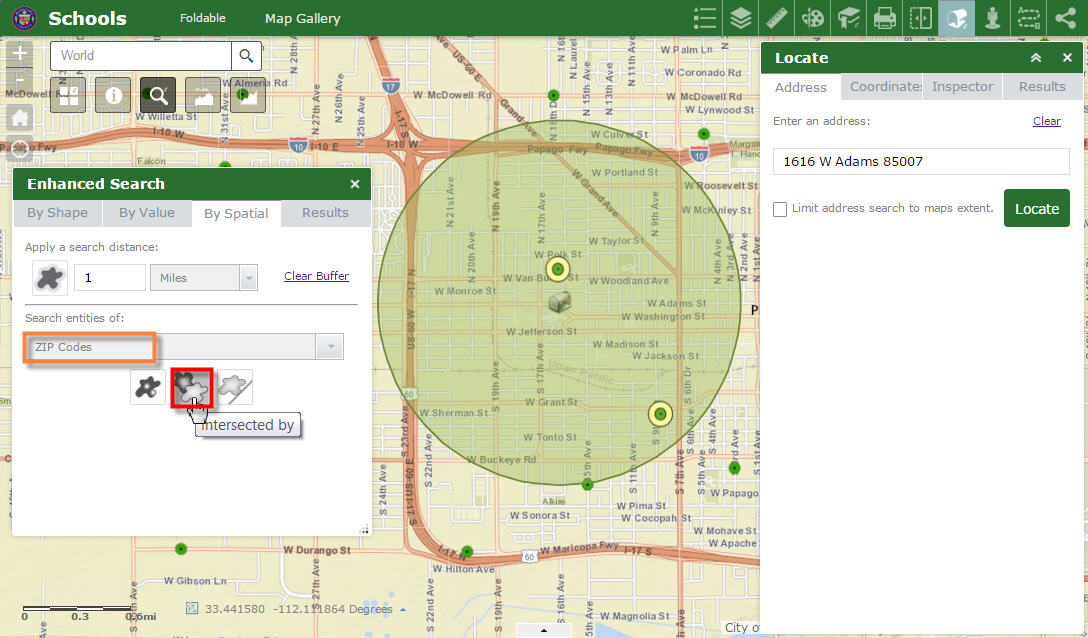
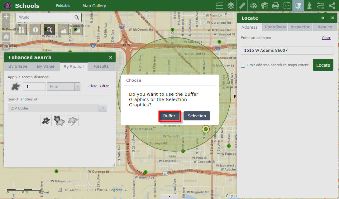
Select the Buffer option.
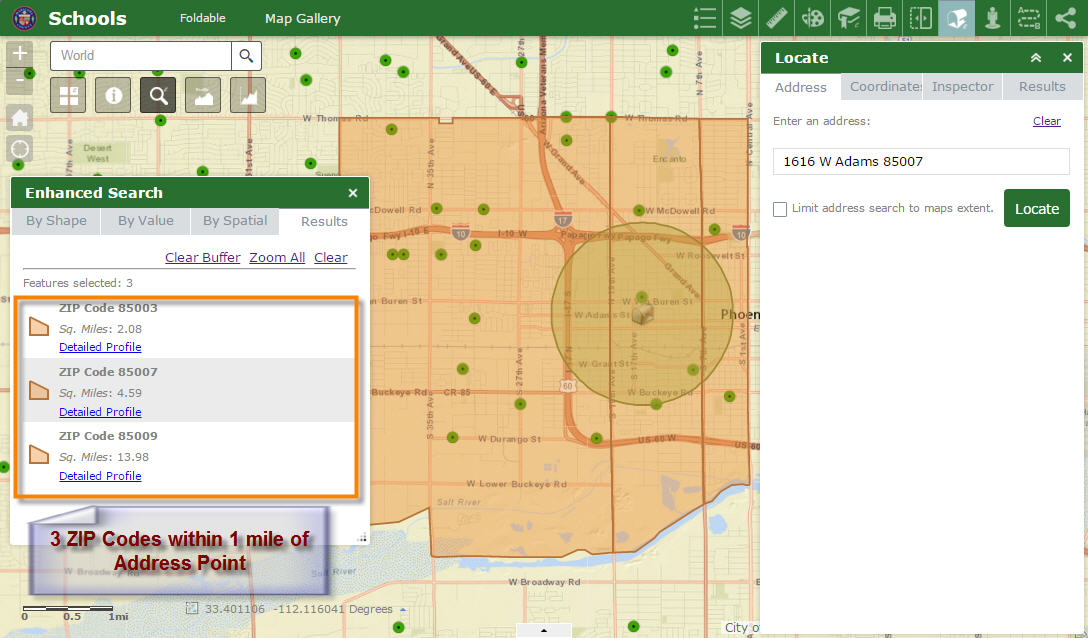
There are 3 ZIP Codes within 1 mile of the Address Point.
The user can also find all the ZIP Codes that are Touched by these 3 selected ZIP Codes.
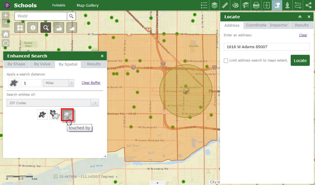
Use the Selection option.
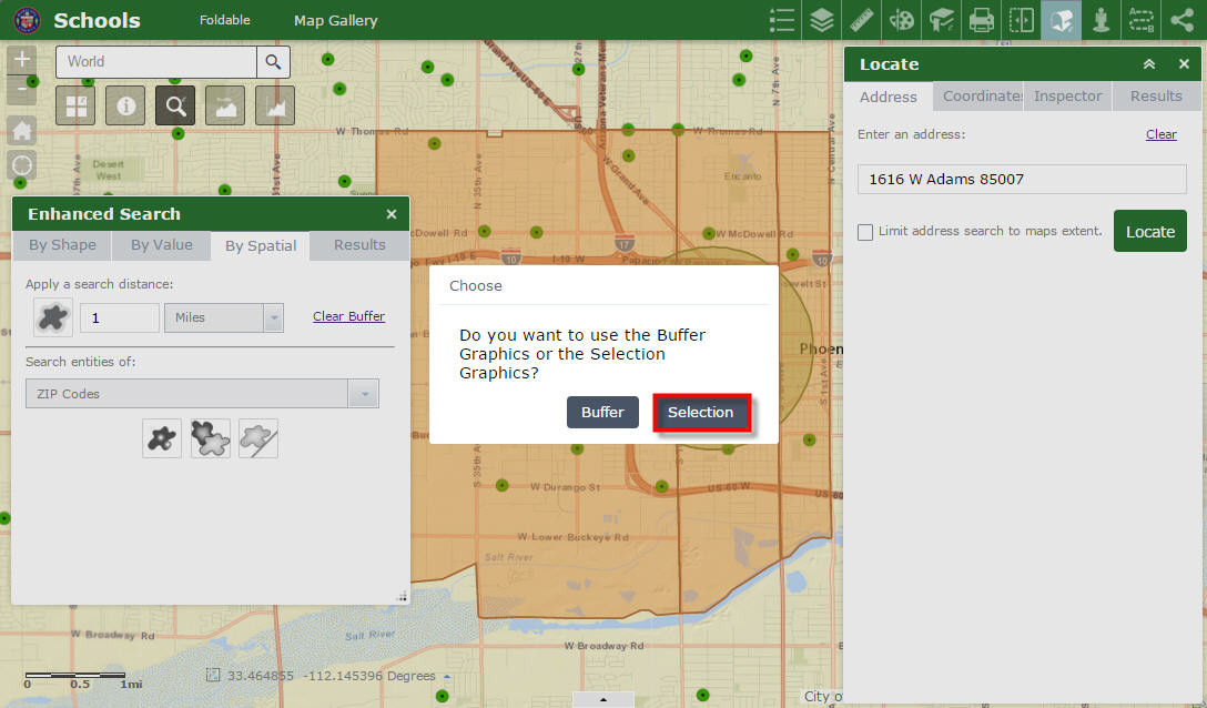
There are 11 ZIP Codes that touch the original 3 selected ZIP Codes.
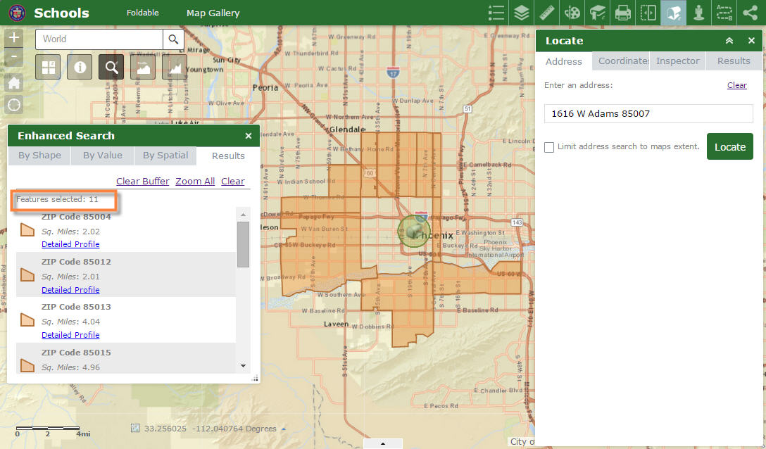
The user can easily find all the Schools within these 11 ZIP Codes.
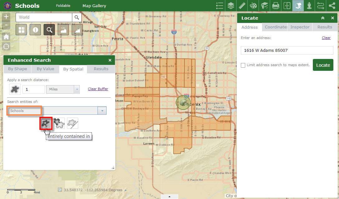
Use the Selection option.
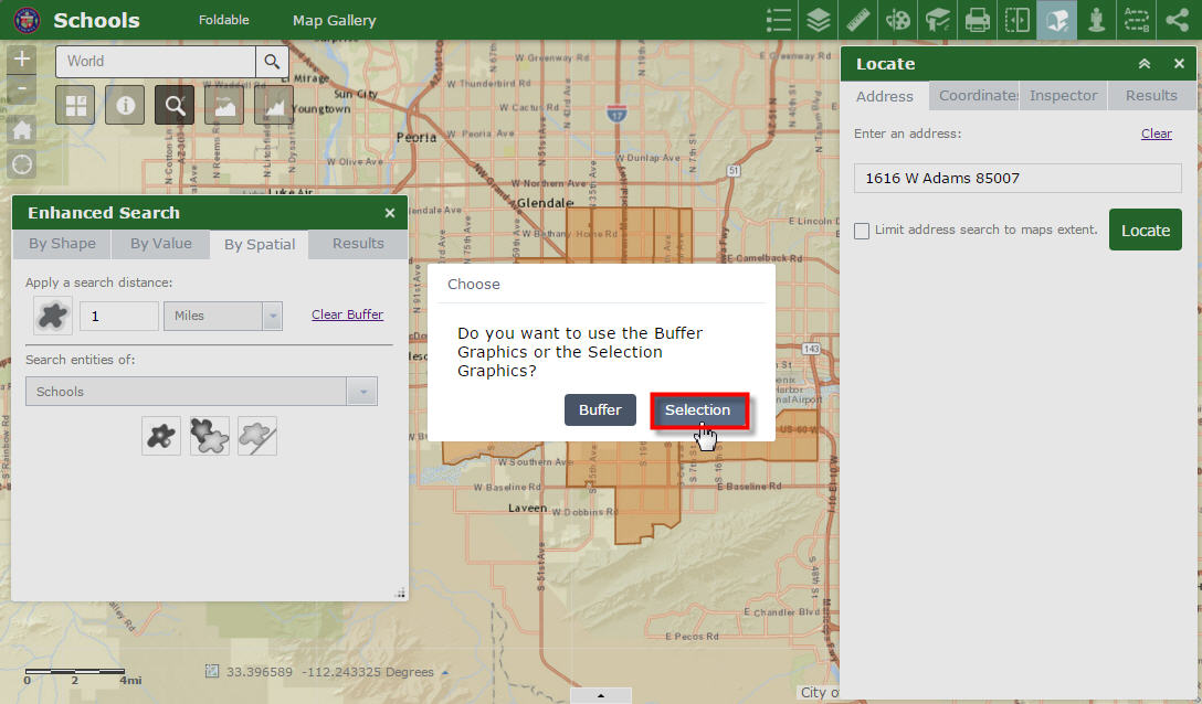
There are 69 Schools within these 11 ZIP Codes.
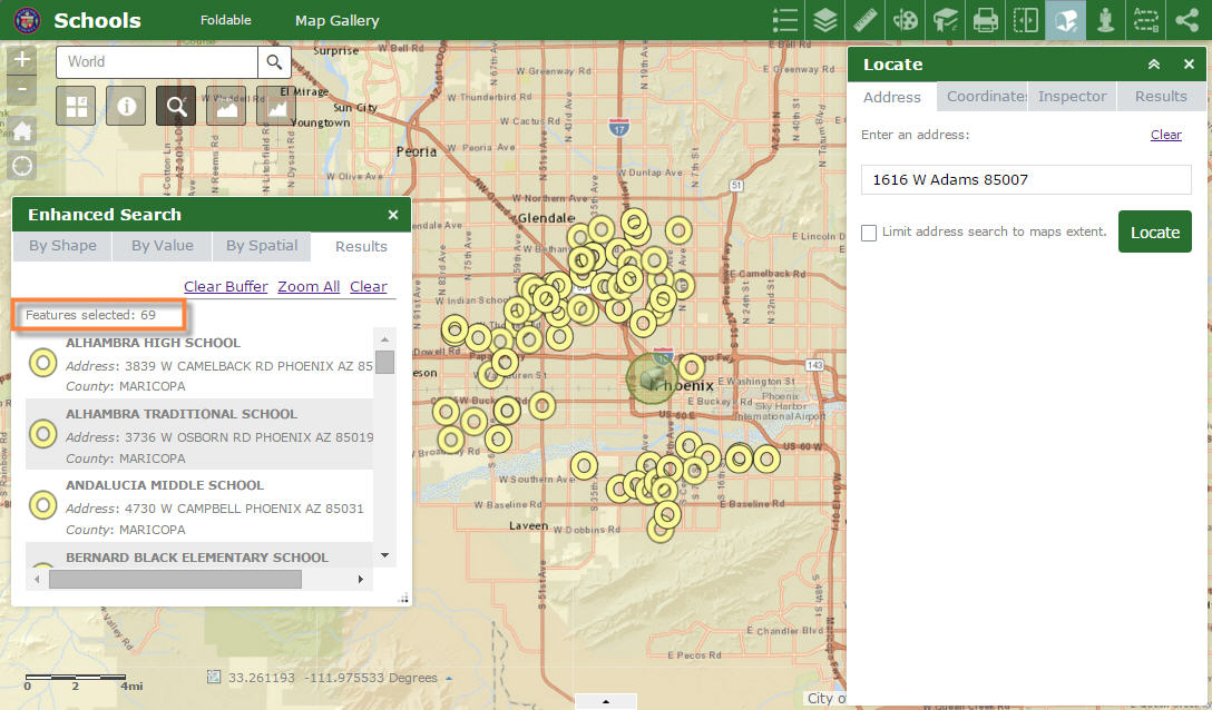
Your Enhanced Search Widget allows the end-user to make complex Spatial Queries without having to seek a GIS Analyst.
Our users are thrilled!
- Mark as Read
- Mark as New
- Bookmark
- Permalink
- Report Inappropriate Content
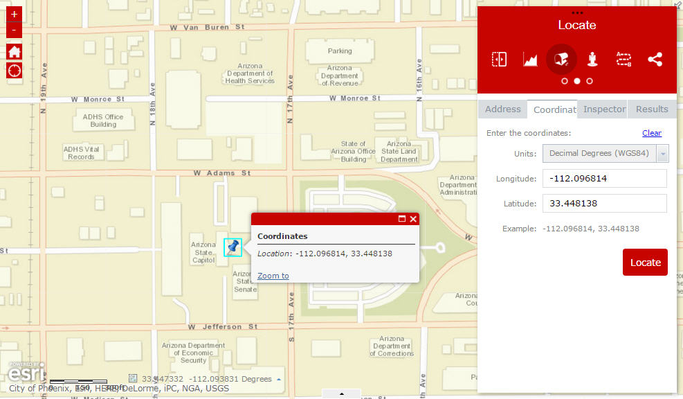
Hi Robert,
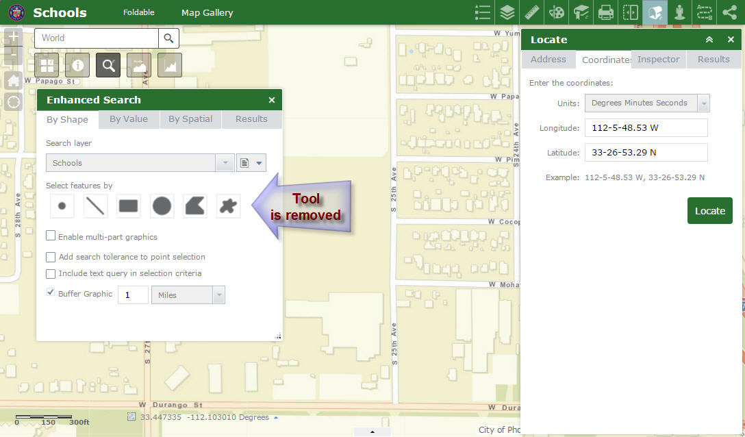
I like how the Use Existing Enhanced Locate Widget Graphics Tool remains hidden when the user has not yet located a point using the Enhanced Locate Widget.
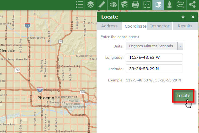
You have fixed all the related issues with the Degrees Minutes Seconds input.
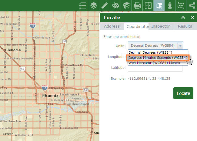
The coordinates are being read correctly.
I like how the Use Existing Enhanced Locate Widget Graphics Tool appears when the user locates a coordinate.
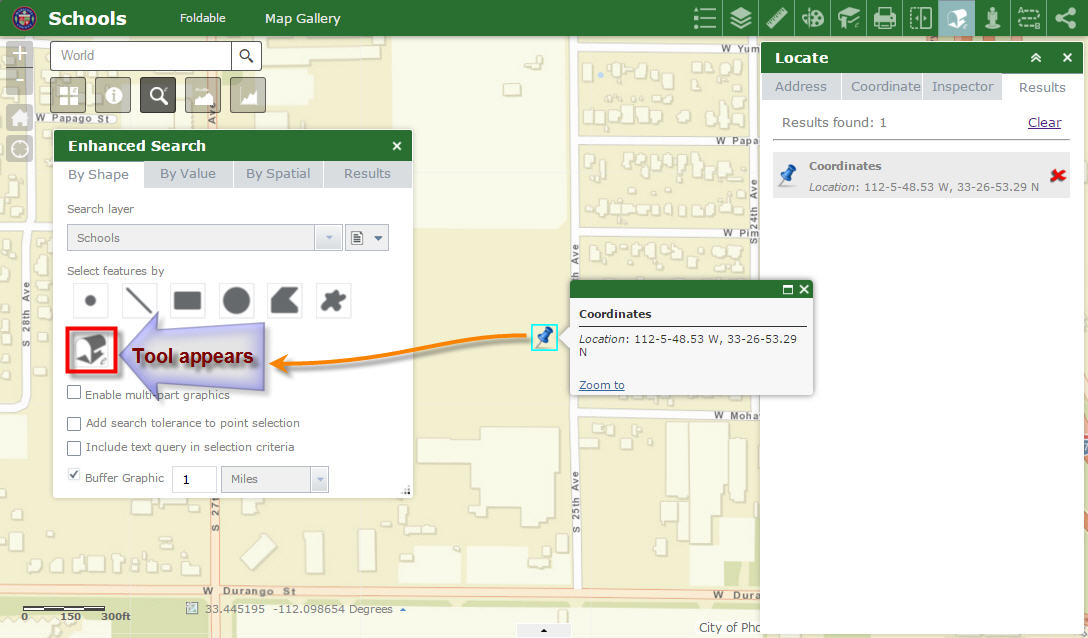
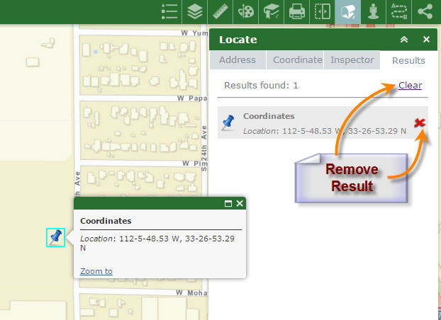
When you clear the results from Enhanced Locate Widget, this tool gets removed.
This keeps the interface clean.
This behavior is better than your Flex Version!
- Mark as Read
- Mark as New
- Bookmark
- Permalink
- Report Inappropriate Content
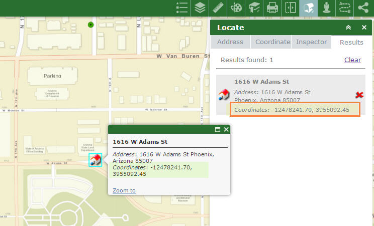
Hi Robert,
I like the clean readout from the Address Inspector Tool.
This is much better than listing separate X and Y coordinate values.
Your new options to Add and Delete from the currently selected set will be very useful.
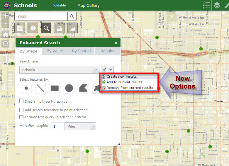
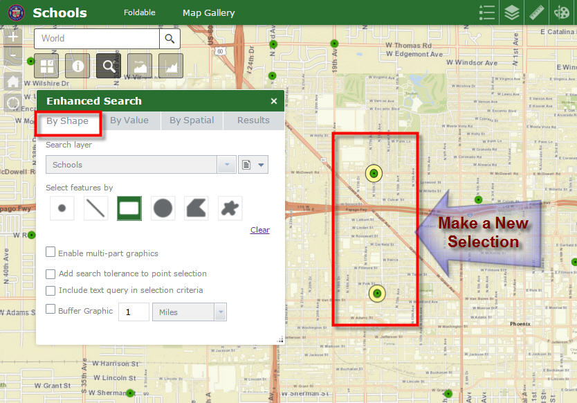
It all works like a charm when you are Selecting by Shape.
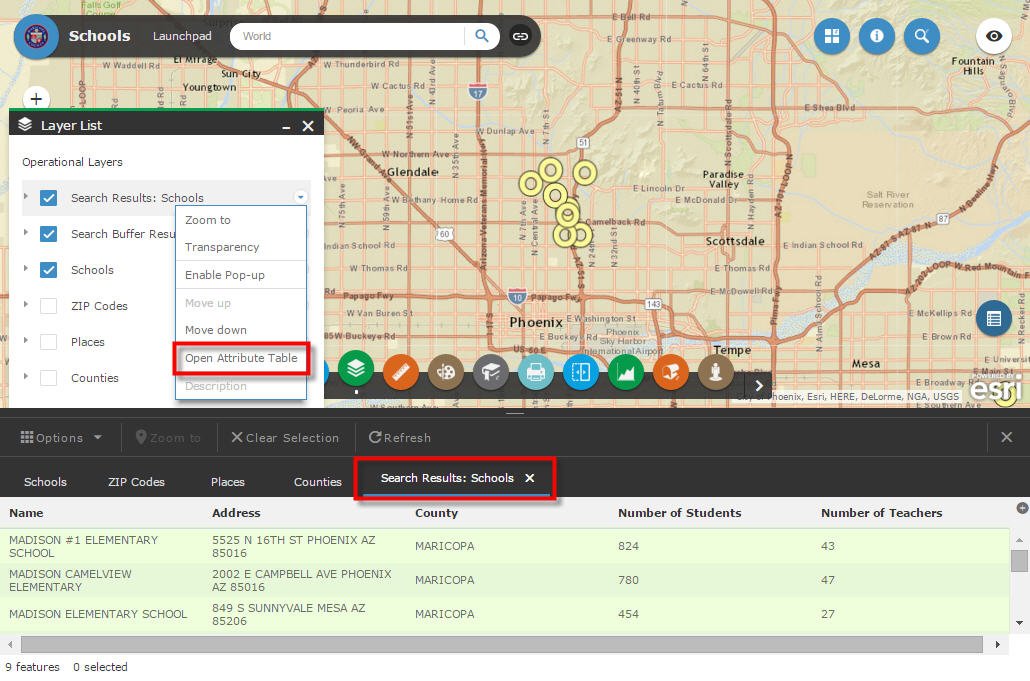
Here I am making a New Selection to select 2 Schools using the Extent Tool.
I am Adding to my current Results.
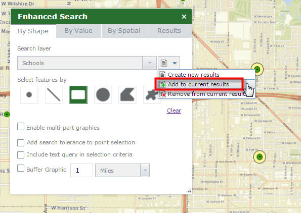
I am adding one School to my Selection.
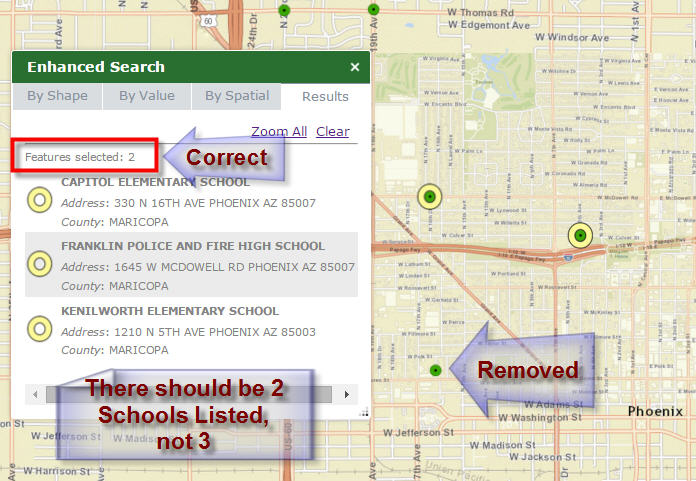
I have a total of 3 Schools in my Results.
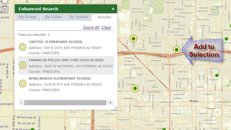
Now I am Removing from my current Results.
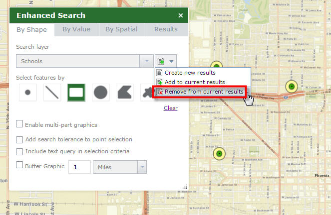
I have removed 1 School.
There should be (3-1) = 2 Schools.
The number of features selected is shown correctly as 2.
However, 3 Schools are listed in the Results Panel.
http://www.tapasdas.com/Maps/Phones/app76
- Mark as Read
- Mark as New
- Bookmark
- Permalink
- Report Inappropriate Content
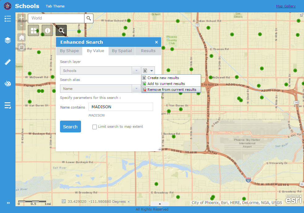
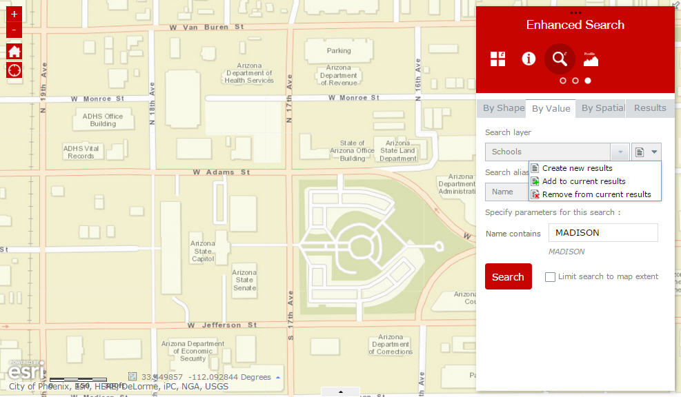
Hi Robert,
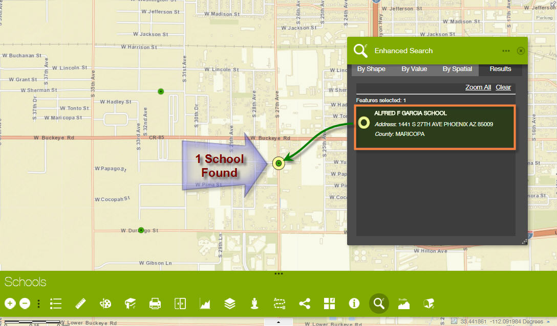
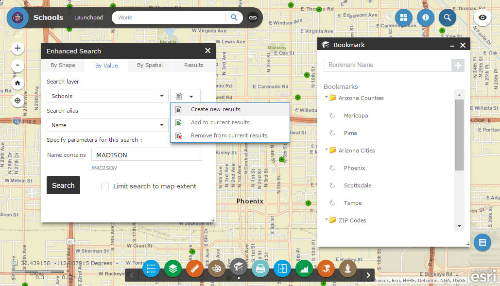
I am selecting a School by Value
Name contains = ALFRED
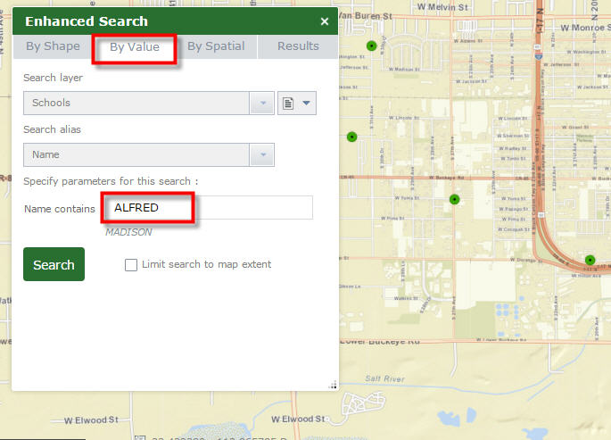
1 School is Selected
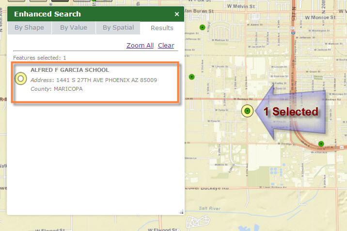
Now, I am opening my Shape Tab.

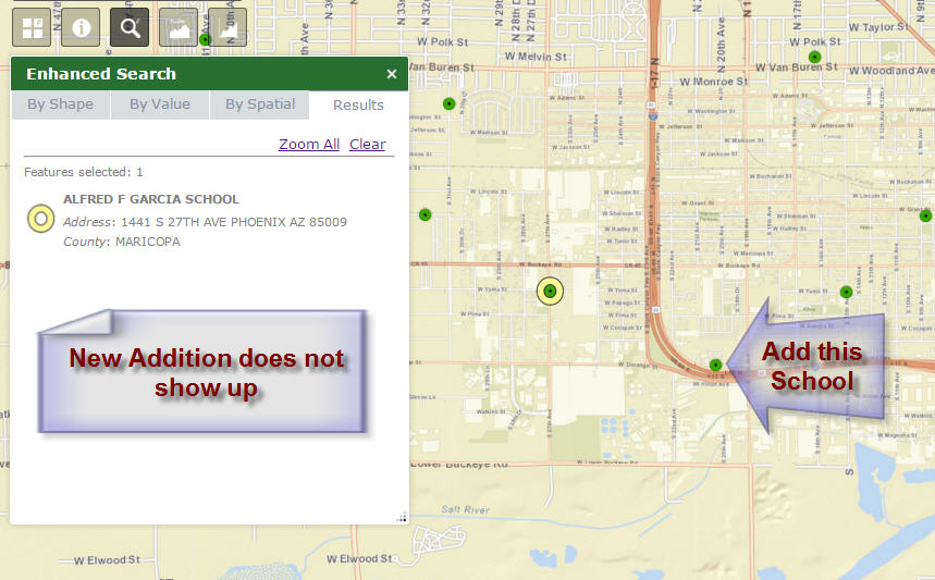
I am Adding to my current results (already has 1 selected)
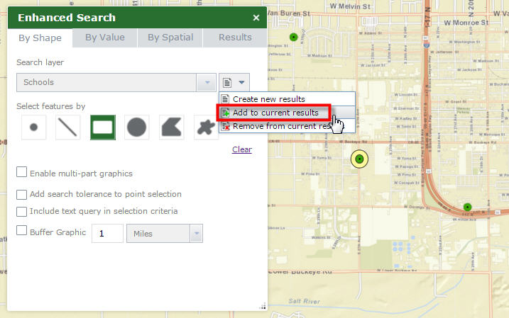
I am adding 1 School.
However, the new addition does not show up in the Results Pane.
- Mark as Read
- Mark as New
- Bookmark
- Permalink
- Report Inappropriate Content
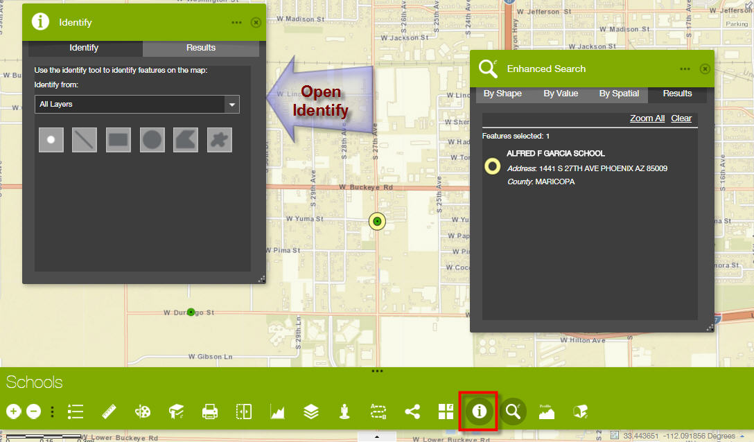
Hi Robert,
I wish there was a way to make the Identify and Enhanced Search Widget work independently with one another, especially while using the Dart Theme which allows you to have multiple widgets open at the same time.
I am using Identify 1.2.0.2 and eSearch 1.2.0.5 in this example:
http://www.tapasdas.com/Maps/Phones/app78
I am performing a Search By Attribute.
Name contains = ALFRED
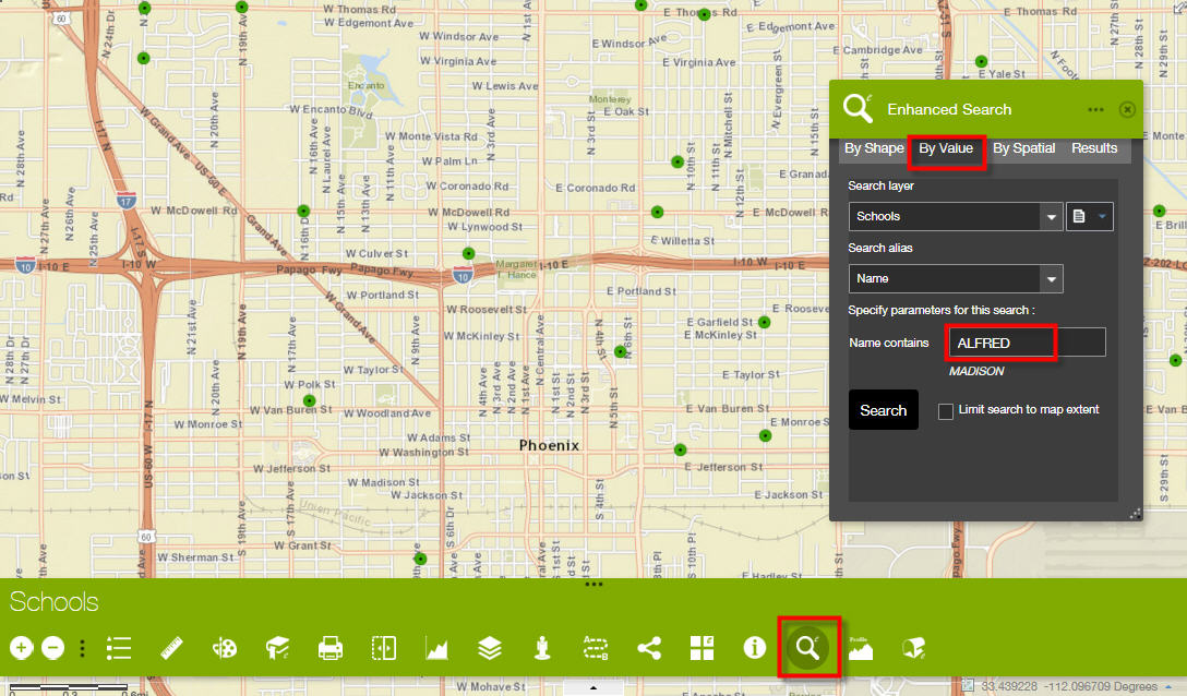
One School is found
Open the Identify Widget
Activate the Extent Tool.
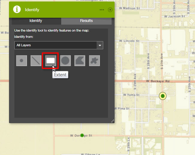
- Select a School with the Extent Tool.
- The Identify Widget hangs!
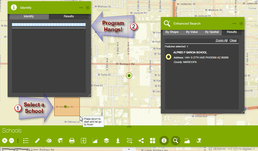
The only way out is to Clear the Results from the Enhanced Search Widget.
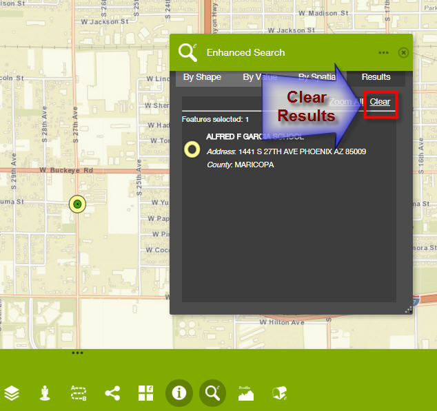
Then, open the Identify Tab, and redo the Select by Extent Tool.
With the Enhanced Search Results cleared, the Identify works as expected.
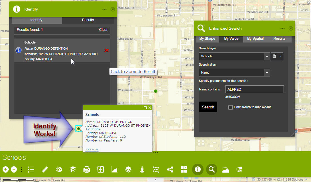
This means the user has to remember, to clear the Search Results first before attempting to perform an Identify.
However, it is not necessary to clear the Identify Results prior to performing an Enhanced Search.
Click on the Search button.
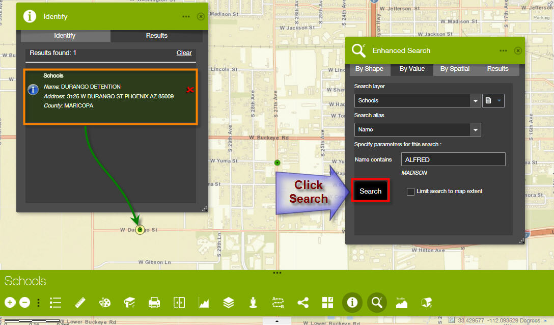
The Enhanced Search works, even though the Identify Results have not been cleared.
It would be a nice enhancement if the Identify Tool could be made to work without having to clear the results from an eSearch.
However, I do understand this can be a very complicated logic to implement with multiple graphics layers. You have already fixed the bug with duplicate listings that was very annoying.
So, you can leave it the way it is.
- Mark as Read
- Mark as New
- Bookmark
- Permalink
- Report Inappropriate Content
Hi Robert,
Here are the rest of my tests using your 8 Custom Widgets on the remaining 5 Themes.
Launchpad Theme
http://www.tapasdas.com/Maps/Phones/app77
This is the perfect theme to use on Desktops and Laptops where you have the screen real estate to keep multiple widgets open.

I like how all the Widgets can be resized, moved, and minimized.
I like how the Search Results can be displayed in the Attribute Table when needed.
Dart Theme
http://www.tapasdas.com/Maps/Phones/app78
This is by far the most stylish theme!
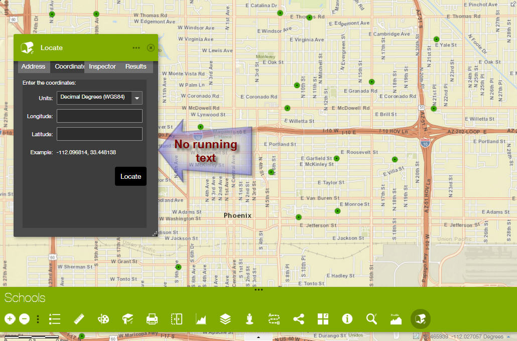
You have fixed the running text issue with the Enhanced Locate Widget.
There is no need to manually widen the widget to show all the text.
Your Elevation Profile Widget looks snazzy under this Theme.
I like how you have enhanced your Google Street View widget to follow the Style Color.
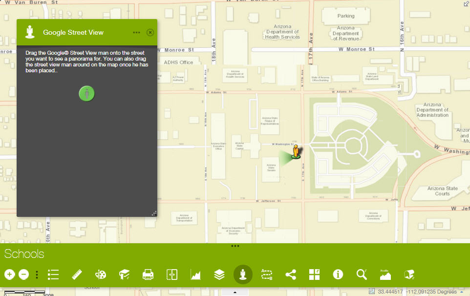
The borders matches the Style Color.
However, the Enhanced Bookmark Widget text is not visible.
Tab Theme
http://www.tapasdas.com/Maps/Phones/app79
Box Theme
http://www.tapasdas.com/Maps/Phones/app80
You have fixed all issues with running text on the Enhanced Locate Widget.
All the controls on the Enhanced Search Widget fits the width.
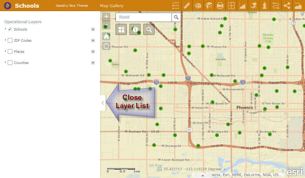
Jewelry Box Theme
http://www.tapasdas.com/Maps/Phones/app81
I like how the Layer List can be moved out of the way by closing the Left Panel.

Robert, this is an extraordinary amount of work you have done for our Web AppBuilder Community. These 8 Custom Widgets boosts the power and functionality of the Web AppBuilder platform to a whole new level.
I am amazed to find how easy it is to create these fully responsive designs in a matter of hours without having to write a single line of code.
Your GUI makes it idiot proof to configure these widgets. I find this far simpler compared to how we had to manually doctor the xml files in the Flex Version.
- Mark as Read
- Mark as New
- Bookmark
- Permalink
- Report Inappropriate Content
Hi Robert,
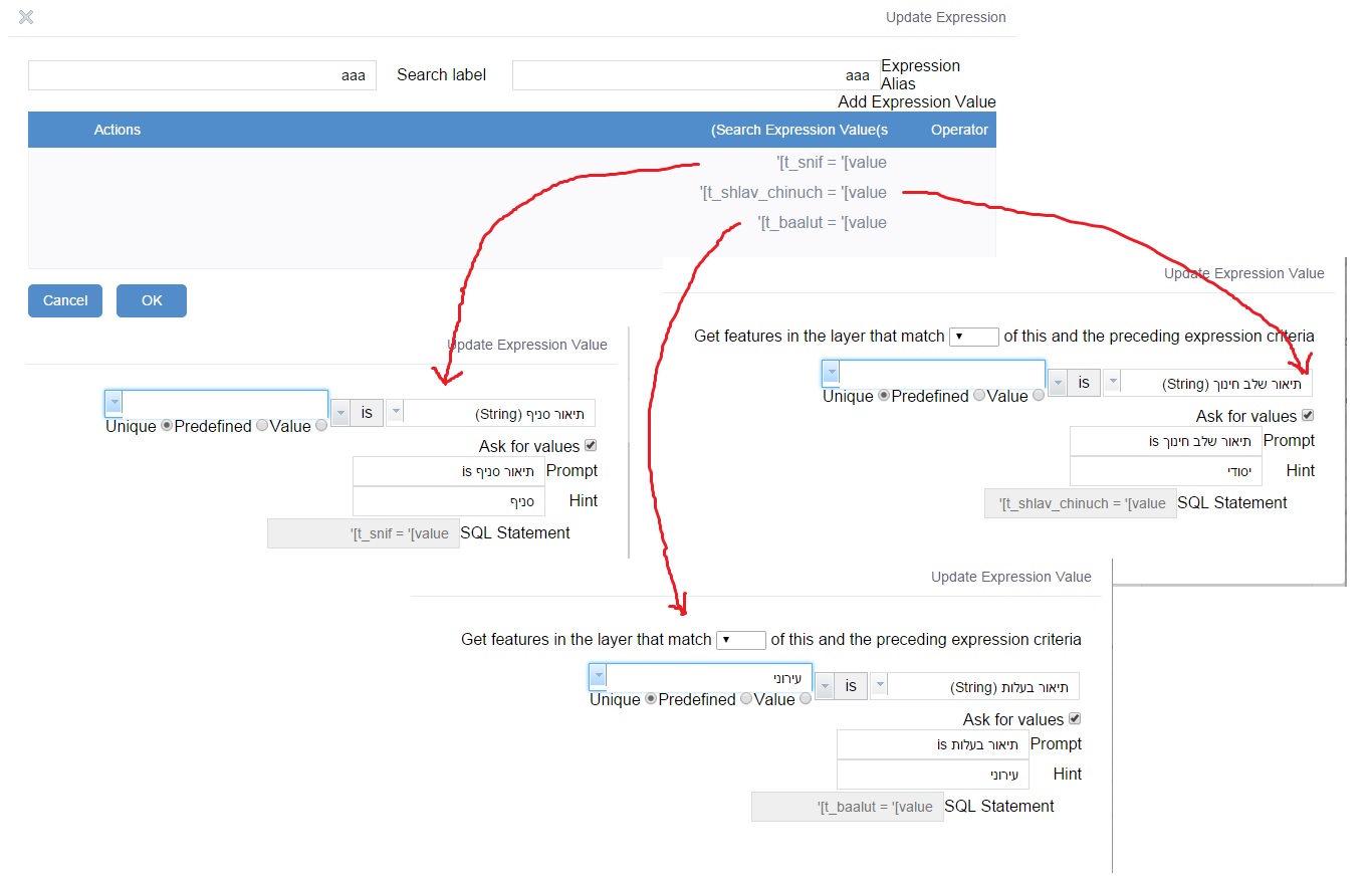
The latest enhancement of Removing required from all inputs unless the field is marked as required (#3 in your list) was so needed and I'm so happy you've added this flexibility to the widget.
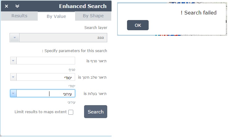
What I found out is that when I ask about two fields or more, it doesn't add the AND between the different fields and therefore the search fails. As soon as I add the and in REST, it works.
I wonder if I use it correctly or it is some kind of a bug.
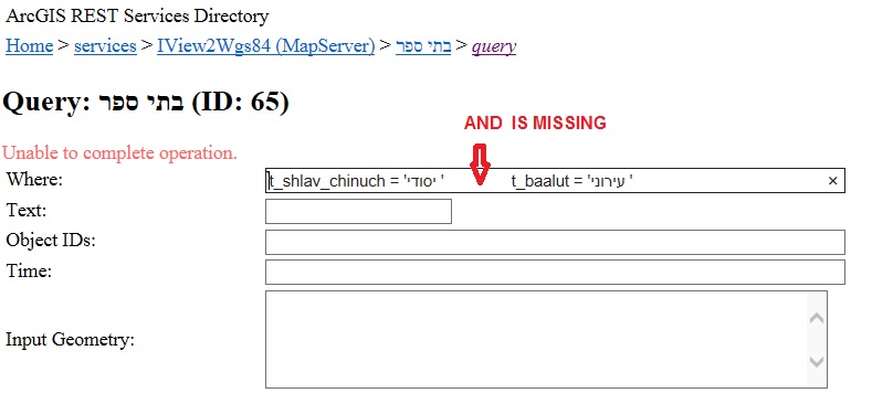
Thanks a lot,
Miri
- Mark as Read
- Mark as New
- Bookmark
- Permalink
- Report Inappropriate Content
Miri,
This is strange what happens when I add a second expression value the "Get features in the layer that match [drop down here] of this and the preceding expression criteria" is set to "All" which equates to "AND" being added to the SQL. You can choose "Any" which means "OR" is added to the SQL. In your screenshots the dropdown is empty... Does the dropdown in your screen shot for the second and third expression value contain any text? It is suppose to default to "All"
- Mark as Read
- Mark as New
- Bookmark
- Permalink
- Report Inappropriate Content
Tapas,
I am having a tough time trying to figure out why people are putting 1=1 in the definition query field. What do I need to change in the help and widget UI that will tell every one that the definition expression is identical to what you would use it for in ArcMap to limit the results to a subset of data.
This the way ArcMap help explains it:
When you specify a dataset that you want to draw as a map layer, you often only want to draw some of the features in the dataset. In these situations, you can define a query expression to select a subset of features for the layer display. This is referred to as a definition query.
For example:
- You might want to display only cities with a population above a certain threshold.
- Many datasets, such as roads and street datasets, have subsets of features (classes), and you might want to define map layers for each class of roads independent of the other features.
- In another case, you might have large enterprise databases with datasets that contain millions of features across wide extents—say for a whole nation or state. Yet, in your maps, you might want to work with only a subset of that data.
If you only want to display and work with a subset of features in a layer, you can apply a definition query to a layer.
When you enter 1=1 there it screws with the search results and does not allow for adding and removing like you are reporting.
- Mark as Read
- Mark as New
- Bookmark
- Permalink
- Report Inappropriate Content
Tapas,
Thanks I got this one figured out already and fixed. I would only occur if it was the first result in the list you were trying to remove (likely why I missed it in my testing initially).
- Mark as Read
- Mark as New
- Bookmark
- Permalink
- Report Inappropriate Content
Robert,
Thanks so much for your detailed and clear explanation of the Definition Query Field.
Now I understand why I should simply leave this field empty.
There is no reason in my test cases to enter the expression "1=1"
I also understand why one may need to limit search results for large datasets, and thus have the need for this filter.
It does not apply to me. I would leave this field blank, and your searches will work just fine.
Thanks for troubleshooting my case and figuring out exactly what I was doing to mess it up!
- Mark as Read
- Mark as New
- Bookmark
- Permalink
- Report Inappropriate Content
Tapas,
Do you have any suggestions on how I can help other not make the same mistake (you are not the first)?
- Mark as Read
- Mark as New
- Bookmark
- Permalink
- Report Inappropriate Content
Robert,
In the PDF Guide on page 145, I had wrongly suggested to use:
Definition Expression: 1=1
http://www.tapasdas.com/wabv2.pdf
I am guessing many who have followed my instructions had added this 1=1 expression.
I am gong to revise this PDF Guide and also include a note on my Using the Web AppBuilder Blog:
- Mark as Read
- Mark as New
- Bookmark
- Permalink
- Report Inappropriate Content
Robert,
I have fixed the errors on pages 145 and 169 of the PDF guide and updated all associated graphics leaving the Definition Expression field empty.
I have included your helpful explanation of the correct use of the Definition Expression in:
- Mark as Read
- Mark as New
- Bookmark
- Permalink
- Report Inappropriate Content
Hi Robert,
I would like the "AND" only on the fields that I enter value in the dropdown list.
All the other fields I would like to ignore.
In the next Query, I would select different fields so it gives me a lot of flexibility.
It works great, it just doesn't add the "ADD" in the request.
I can try doing it myself, I just wanted to know how it suppose to work.
Can you try select values in only part of the fields and see if you get a valid result?
Thanks,
Miri
- Mark as Read
- Mark as New
- Bookmark
- Permalink
- Report Inappropriate Content
Miri,
It does work in my testing just fine if you add a second expression value and it is not marked required and you do not fill out this expression value.
I asked you some questions in my previous reply can you please answer those?
- Mark as Read
- Mark as New
- Bookmark
- Permalink
- Report Inappropriate Content
Hi Robert,
I am interested in using this widget only for the Graphical search functionality. I had hoped I could simply point it to a map service that has around 50 layers, and it would have an All Layers kind of functionality, similar to Identify. However, I discovered I had to add every layer individually, with a dummy expressions. This is okay, however. I am just using a random field for each layer, with Ask for Values as an expression.
But, if eSearch could have an "All Layers" as the top choice in the Search Layer menu in the Graphical Search tab, that would be great. What do you think?
Basically, this kind of replicates Identify. ...why?.. Because eSearch sends results to the Attribute Table, this is why. If Identify could do that it would not be necessary. However I think I'd asked you about this earlier and I think there was a reason for this. Perhaps because of using identify instead of querytask? Anyhow thank you for your thoughts on this Robert and fellow widget fans.
edit: I am also experiencing issues, some layers are not loading, and also results from one layer are showing up in another. And sometimes polygon symbology is not working, it is not shading in the result only outlinng in red, and I have already tried changing it. Maybe this is all happening because I am using it in such an unusual way. I am using an internal service, but I will be sure to post example sometime today, if I can not get it working, using a public service and map.
- Mark as Read
- Mark as New
- Bookmark
- Permalink
- Report Inappropriate Content
hi Robert,
as far as ideas for future enhancements.
i have one that has to do with the attribute table.
i realize you are using what ESRI provides but it would be really handy to be able to export a .csv file that reflects the columns that have been turned off. i also notice that the column names are the actual names and not the aliases that i have assigned. maybe this should go into the "ESRI ideas" site instead of here.
- Mark as Read
- Mark as New
- Bookmark
- Permalink
- Report Inappropriate Content
glenn hazelton good idea, and while perhaps Robert could grab the data and prune those columns before passing, ESRI might as well do this at the Attrib. Table widget level anyway. Perhaps ESRI could set a property in the Attrib widget to just allow widgets sending data into the Attrib Table to flag columns to hide.
Something else that just occurred to me: can we make hotlinks in the Attribute Table? You know how we can make them in Robert's Identify? Kind of like in the infowindow popups. I use them to make the Property Tax ID # link to the tax assessor card for each parcel. Would be nice to have that in the Attrib. Table. I am sure it could be hacked via html/css or someuch but it would be neat if ESRI designed the attribute Table to be very customizable like infowindow popup. I didn't see anything about it in the documention but if there is some description on it either Esri or unofficial I'll take a look and give it a try.
- Mark as Read
- Mark as New
- Bookmark
- Permalink
- Report Inappropriate Content
thanks for continuing this dialog.
another odd thing that is happening to me..
if i export the attributes for a selected set
first it wants to save it as an .html file, even though the prompt has asked if i want to save a CSV file.
so i have to change the file type and save.
and then try to open the .csv file by double clicking on it.
excel opens but it is not seeing it as a comma delimited file.
if i open excel and choose open i can manually set it to work but this seems odd.
i have other .csv files that do open correctly.
i am confused about this.
maybe it is an excel setting that i have make to set the default to comma delimited instead of fixed fields
- Mark as Read
- Mark as New
- Bookmark
- Permalink
- Report Inappropriate Content
Kevin,
Having an all layers option on the Graphical search is not practical. What it comes down to is understanding the mechanisms used behind the scenes. The Identify widget make this possible because the IdentifyTask uses the map to identify features from the whole map (if so configured). The eSearch (and Query widget) use a QueryTask which is one layer of a map service at a time. So in your scenario I would have to send 50 round trip queryTasks to the server to see if the graphic intersect the feature layer.
The identify widget would have to be majorly re-coded to produce a featureLayer in order for it to send results to the Attribute table (just not in any of my plans for this widget currently).
I am also experiencing issues, some layers are not loading, and also results from one layer are showing up in another. And sometimes polygon symbology is not working, it is not shading in the result only outlinng in red, and I have already tried changing it
Not sure where to begin here... I have not had anyone report of having these issues.
- Mark as Read
- Mark as New
- Bookmark
- Permalink
- Report Inappropriate Content
Glenn,
Because I am using the esri Attribute Table widget there is little I have control over. Adding it to the Ideas site is the way to go.
- Mark as Read
- Mark as New
- Bookmark
- Permalink
- Report Inappropriate Content
Hi Robert,
Yes of course, I am just getting in to it and I'll report back on specific issues with more detail and example site, if needed.
As to IdentifyTask vs QueryTask I understand, and this is what I'd thought, but I just wanted to doublecheck. And yes...that makes sense, that would be an extreme amount of network traffic, that many requests. Hm. Well it is ok, users can just go layer by layer. Which to be honest, it would be rather ungainly to see dozens of results layers pop up at once. Almost unusable. So good point, that isn't really a sensible use case. I will keep working today on employing your widget, for my rather unorthodox purposes. Thanks for being here and discussing!
Oh, also: The multipart graphic search is GREAT. I think it will be very appreciated by our people.
edit: Also, I figured out my symbology issue. It was configured to get it from Server. Now that I see how that works, that's really awesome! I am going to override it in this case, but that's slick.
Kevin