- Home
- :
- All Communities
- :
- Industries
- :
- Water Utilities
- :
- Water Utilities Questions
- :
- Valve symbols too close together
- Subscribe to RSS Feed
- Mark Topic as New
- Mark Topic as Read
- Float this Topic for Current User
- Bookmark
- Subscribe
- Mute
- Printer Friendly Page
Valve symbols too close together
- Mark as New
- Bookmark
- Subscribe
- Mute
- Subscribe to RSS Feed
- Permalink
- Report Inappropriate Content
What are other water utilities doing to fix the "nearby features turning into symbol blobs" problem?
All of our above-ground features are input in the map as their actual location. The problem I'm having is except in extremely close-scale maps, valves (and some other features) overlap and show up as a little blob of symbols. It's impossible to see how many valves exist at each junction. It's really a problem for our field crew, as well as engineers and other people we need to share maps with.
Is there a way to keep the real location data but show the symbols offset along the mainlines for map exhibits? Nothing I've come across really seems to fit the bill.
Solved! Go to Solution.
Accepted Solutions
- Mark as New
- Bookmark
- Subscribe
- Mute
- Subscribe to RSS Feed
- Permalink
- Report Inappropriate Content
Alright well, here's the workaround I came up with if anyone reading this is having the same problem.
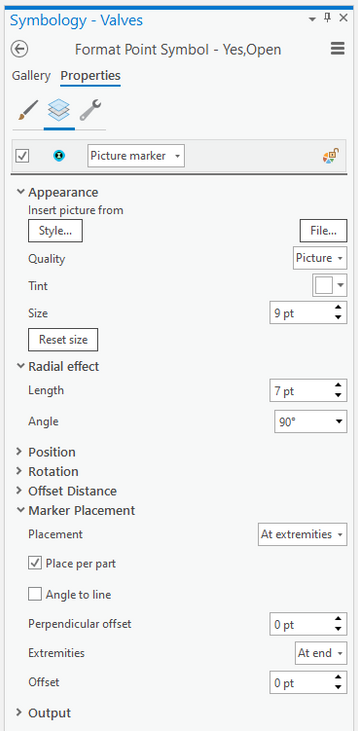
What I did was add a "Radial Effect" and place the valve symbols at the endpoint of this "arm". By changing the radial length I can adjust the spacing of these symbols.
Here are the specifics for the symbology:
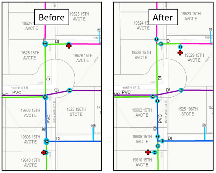
I did the same for our "Hydrants" and "Control Valves" layers. They all have to have a symbol rotation field for this to work. It's not perfect (in areas with a lot of features it's still a confusing mess) but it's an improvement. See the before and after for a 1 in = 100 ft scale map:
Unfortunately it's not feasible for us to go all-online. We still need to create static, paper maps for a variety of situations.
- Mark as New
- Bookmark
- Subscribe
- Mute
- Subscribe to RSS Feed
- Permalink
- Report Inappropriate Content
Is something like Web Appbuilder for viewing zoomed in as needed an option for you?
- Mark as New
- Bookmark
- Subscribe
- Mute
- Subscribe to RSS Feed
- Permalink
- Report Inappropriate Content
Thanks for the reply Bill. Not sure I understand. When our crews are using Collector or AGOL, they can zoom in to see how many valves are at each junction. We have to send a lot of PDF maps though, and that's where overlapping symbols becomes an issue.
- Mark as New
- Bookmark
- Subscribe
- Mute
- Subscribe to RSS Feed
- Permalink
- Report Inappropriate Content
Oh, paper.
We have the opposite issue - but for similar reasons.
As we converted all of our ink & Mylar maps to digital using Arc/Info Workstation we still needed to reproduce the blue-line sets of run books at scales such as 1"=200'.
In order to see the valves and be able to make since of them the needed to be about 10 feet in diameter.
We compromised to place them a little more than 10 feet away in cases such as 4-way valve packs.
Now we are looking at using high precision (cm) GPS field editing to get the "real" locations.
Added benefit is hoping to get good vertical numbers too.
Thought about data-driven pages for main intersections and dense areas but the number of pages would weigh several pounds to drag around and have to thumb through.
Maybe some schematics options are available in the new utility model.
- Mark as New
- Bookmark
- Subscribe
- Mute
- Subscribe to RSS Feed
- Permalink
- Report Inappropriate Content
Bill has a very good point, you might find it a better use of your resources to give those people (for example contractors or engineering consultants) secure access to the info they need as interactive maps shared through AGOL instead of doing a significant amount of work to create and maintain paper map products that cartographically mitigate the fact that your actual assets are densely packed together.
- Mark as New
- Bookmark
- Subscribe
- Mute
- Subscribe to RSS Feed
- Permalink
- Report Inappropriate Content
Alright well, here's the workaround I came up with if anyone reading this is having the same problem.
What I did was add a "Radial Effect" and place the valve symbols at the endpoint of this "arm". By changing the radial length I can adjust the spacing of these symbols.
Here are the specifics for the symbology:
I did the same for our "Hydrants" and "Control Valves" layers. They all have to have a symbol rotation field for this to work. It's not perfect (in areas with a lot of features it's still a confusing mess) but it's an improvement. See the before and after for a 1 in = 100 ft scale map:
Unfortunately it's not feasible for us to go all-online. We still need to create static, paper maps for a variety of situations.

