- Home
- :
- All Communities
- :
- Industries
- :
- Water Resources
- :
- Water Resources Questions
- :
- Re: red lines in archydro
- Subscribe to RSS Feed
- Mark Topic as New
- Mark Topic as Read
- Float this Topic for Current User
- Bookmark
- Subscribe
- Mute
- Printer Friendly Page
red lines in archydro
- Mark as New
- Bookmark
- Subscribe
- Mute
- Subscribe to RSS Feed
- Permalink
what is the meaning of red lines that appears after running Denditric terrain processing whit imposed drainage line and wall model?
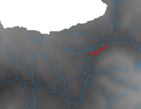
Why red lines remains also whit all deactivated layer in dataframe?
Can someone explain this? thank you! 
- Mark as New
- Bookmark
- Subscribe
- Mute
- Subscribe to RSS Feed
- Permalink
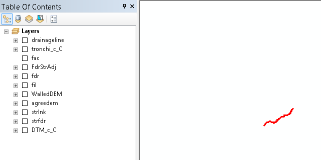
I've never seen red lines like this if the process completes as it should. Sometimes Arc Hydro will "leave" some graphic points or lines (not GIS data or layers) if the process doesn't complete correctly for some reason. These can be selected as graphics and deleted.
I would look at the results and make sure the process completed correctly.
I assume by with imposed drainage line and wall you mean you are burning streams and building walls, right?
- Mark as New
- Bookmark
- Subscribe
- Mute
- Subscribe to RSS Feed
- Permalink
Thanks Mark! I get this error in "create drainage line" while running model builder. But I don't know how to solve...:
CreateDrainageLineStructures: -94277 System.Runtime.InteropServices.COMException (0x80040207): An invalid SQL statement was used. [SELECT * FROM drainageline WHERE Shape_Length < 289,952360305348]
at ESRI.ArcGIS.Geodatabase.IFeatureClass.Search(IQueryFilter filter, Boolean Recycling)
at ESRI.APWR.ApHydro.ArcHydroOp.CreateDrainageLineStructures(ApLayers apLayers, String streamGPValue, Double stepsize, Double startElevation, Boolean bCleanRighAngle, ITrackCancel& trackcancel, IGPMessages& messages, String& exMessage, Int32 debugLevel, Int32 iThreshold, Double nCells4ShortLine, Boolean bUseRasterExtent, List`1 lStructType2Exclude, String& flowsplittablename) in C:\Builds\HydroSolutions\10.2_ArcHydro\Sources\ArcHydroTools\src\ApHydro\ArcHydroOp.vb:line 98170
- Mark as New
- Bookmark
- Subscribe
- Mute
- Subscribe to RSS Feed
- Permalink
Hi Ivan
It seem that ArcGIS is complaining that you have an invalid sql statement. Check to make sure your syntax is correct (i.e. shapefiles\feature classes and vbscript\python)
Regards
- Mark as New
- Bookmark
- Subscribe
- Mute
- Subscribe to RSS Feed
- Permalink
Hi Ivan
Just a note, the red line seems to be from the path trace tool, which is a graphic representation of the flow path trace.
Regards
- Mark as New
- Bookmark
- Subscribe
- Mute
- Subscribe to RSS Feed
- Permalink
Ivan,
There are several things I do to reduce the number of errors when using Arc Hydro. A while back I started a thread called "Arc Hydro Problem Solvers". It became a repository for dealing with errors. You can find it at ArcHydro Problem Solvers
Maybe you can find something in there that will address this error.
Best,
Mark
- Mark as New
- Bookmark
- Subscribe
- Mute
- Subscribe to RSS Feed
- Permalink
I resolved my problem using another stream feature extracted from topographic maps of my region. I downloaded about 719 topographic shapefiles and then I extracted my stream lines, lake polygon, and other features using iterator. Then I used Topo to raster to create my hydrodem.