- Home
- :
- All Communities
- :
- Industries
- :
- Water Resources
- :
- Water Resources Questions
- :
- drainage line do not match DEM stream line using A...
- Subscribe to RSS Feed
- Mark Topic as New
- Mark Topic as Read
- Float this Topic for Current User
- Bookmark
- Subscribe
- Mute
- Printer Friendly Page
drainage line do not match DEM stream line using Arc HYDRO
- Mark as New
- Bookmark
- Subscribe
- Mute
- Subscribe to RSS Feed
- Permalink
- Report Inappropriate Content
Hi, I am wondering if anyone can help me on my data run. I've been running my DEM using Arc Hydro, drainage line output do not match the DEM or the base map stream.
What could be the problem? Is there any step that I need to do?
The red line is my stream from delineated DEM, the blue line is the basemap from ArcGIS software.
Below are my process:
- DEM repositioning
- fill sink
- flow direction
- flow accumulation
- Stream Def
etc based on Arc Hydro sequence
- Mark as New
- Bookmark
- Subscribe
- Mute
- Subscribe to RSS Feed
- Permalink
- Report Inappropriate Content
Check the projections on your source data as well as your data frame. They must be the same.
- Mark as New
- Bookmark
- Subscribe
- Mute
- Subscribe to RSS Feed
- Permalink
- Report Inappropriate Content
I already checked and they have the same projection. I also tried to do georeference on DEM but still the same output.
- Mark as New
- Bookmark
- Subscribe
- Mute
- Subscribe to RSS Feed
- Permalink
- Report Inappropriate Content
try to use another (finer) DEM
- Mark as New
- Bookmark
- Subscribe
- Mute
- Subscribe to RSS Feed
- Permalink
- Report Inappropriate Content
I took a screen snip of your map and drew blue lines where the ESRI topo would show the streams. Freehanded these, so not that pretty. Then I drew fainter green lines from your red lines to my blue lines where they visually seem to match in shape.
It looks like your red lines are offset almost like someone stretched the image of the redlines to the east (or compressed the topo in the East-West direction).
What does it look like overlaid on your DEM? Can you provide a view with the red lines overlaid on the DEM where the DEM has a high contrasting color ramp? Does the ESRI topo line up with your DEM?

- Mark as New
- Bookmark
- Subscribe
- Mute
- Subscribe to RSS Feed
- Permalink
- Report Inappropriate Content
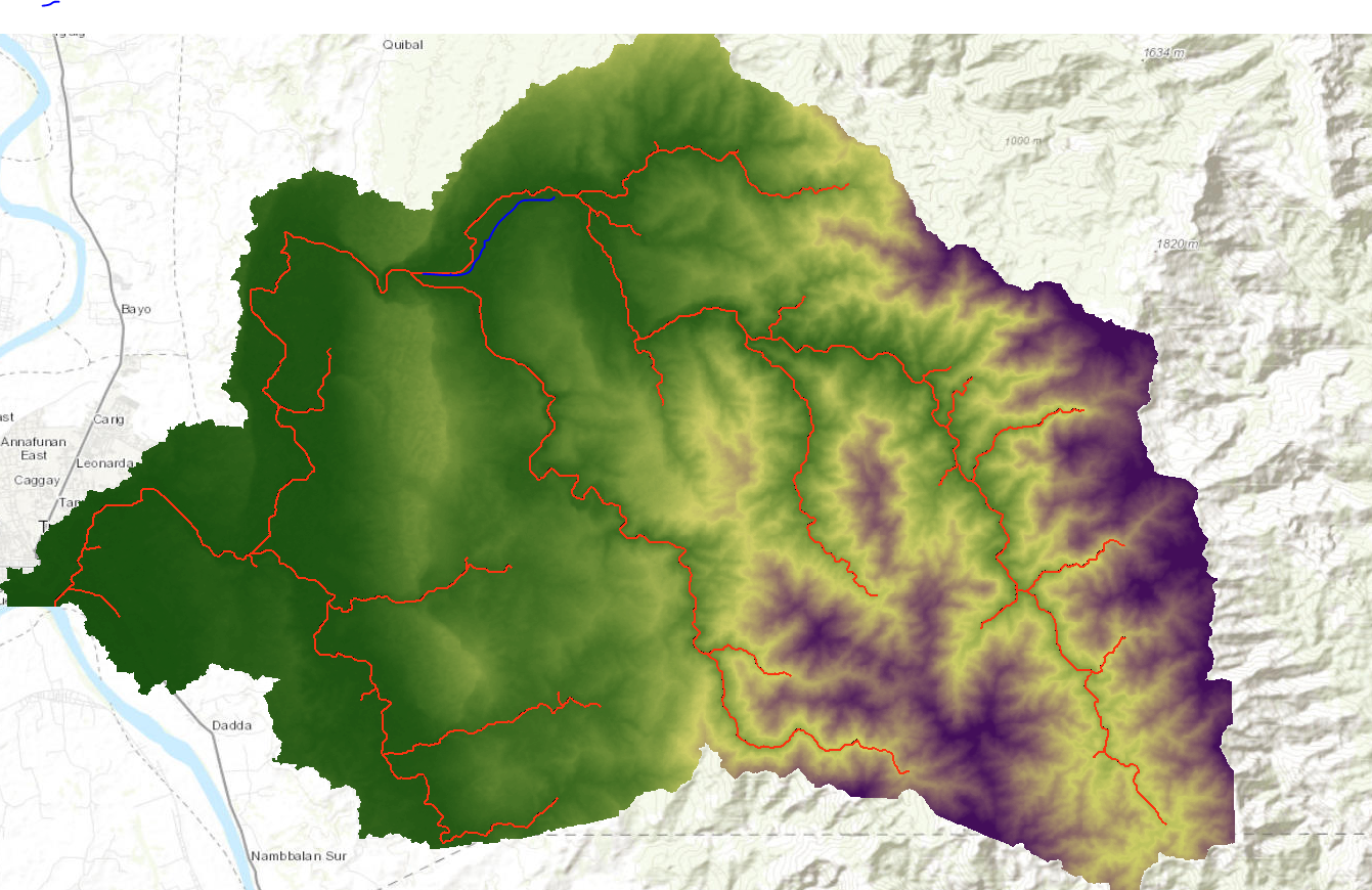
Hello @MarkBoucher , I'm sorry I am not an expert in ARCGis, I am currently doing my dissertation. Yes, my DEM line up with ESRI topo. When I delineate and process the drainage line it does not match the DEM. It was moved a little bit out of the stream line from DEM. I don't know how to solve the problem, I've been taking so much time for this and tried other option like georeferencing but still same problem. Blue line is the topo and DEM (just sketch small line). Attached also is the actual ASTER DEM.
- Mark as New
- Bookmark
- Subscribe
- Mute
- Subscribe to RSS Feed
- Permalink
- Report Inappropriate Content
To me, in your first image in this latest reply (Capture.PNG) the red lines on the DEM show a very good match compared to the first image you posted with the red lines on the ESRI topo.
There is one obvious mismatch where it looks like you drew a blue line. Possibly this is a very flat plain where the DEM has poor definition.
To can train the DEM to follow an actual creek or river, or to make it flow correctly "through" a road embankment at a road crossing, you need to "burn in the streams". The process to follow is to draw lines in a dataset called "agreestream" where ever you need to force a stream to be. This line should start and end on DEM cells that are correct to make sure there is good "continuity" between where the DEM gives you right answers and where you need to correct it. You don't have to put in lines for every stream in the DEM. You only need agreestream lines where the DEM is not "hydrologically correct". You can't always see this so it is a trial and error process.
Then you run the DEM Reconditioning with the agreestream dataset which lowers the DEM elevation where the streams need to be. Then build walls if needed. Building wall works the same as burning streams using a dataset named "innerwalls", but it results in a DEM where the cells are raised to stop flows from going where they shouldn't. Then fill sinks. Don't worry if the streams are burned really deep (-1000) or walls high (+500). The fill sinks will raise the DEM enough. The walls will still be high, but in the end you are not needing the right elevation, you are needing the right flow direction. You would always use the original DEM for elevations any way. The final agreeDEM will be "hydrologically correct".
After you fill the sinks the DEM should be "hydrologically correct" and the flow direction>flow accumulation and later steps should result in what you want. If not, add/adjust agreestream lines or innerwalls and repeat.
The highlighted steps in this screen capture of the ArcHydro menu shows the steps I use up to Stream Definition. I'm not sure if you are going beyond that.

Years ago (2012!) started a thread call "ArcHydro Problem Solvers" where I documented what I learned about ArcHydro "the hard way". Others added value to this and it is a good resource. The process I've used described there: https://community.esri.com/t5/water-resources-questions/archydro-problem-solvers/m-p/499209#M2440
Good luck!
Mark
- Mark as New
- Bookmark
- Subscribe
- Mute
- Subscribe to RSS Feed
- Permalink
- Report Inappropriate Content
Hi @MarkBoucher , apologies, is there a step I can follow to do the agreestream? I have no idea how to start the process. Thank you very much for helping me.
- Mark as New
- Bookmark
- Subscribe
- Mute
- Subscribe to RSS Feed
- Permalink
- Report Inappropriate Content
@MarkBoucher thank you for this, I followed your suggestion and my stream got improved. ALthough there are other parts of the stream got doubled and not match the topo.
- Mark as New
- Bookmark
- Subscribe
- Mute
- Subscribe to RSS Feed
- Permalink
- Report Inappropriate Content
Michiekoy,
I see that your post at https://community.esri.com/t5/water-resources-questions/how-to-burn-stream-in-dem/td-p/1196635 is similar to this. I haven't used the openstreet map datasets, but we have one for our County that was created by someone who, it was rumored, manually digitized the creeks off of ortho photos and possibly did some on-the-ground observations. I've found that is inaccurate in many places.
What I've learned from using this creek layer is that I should not rely on line work by others to define the stream where the DEM can do it for me. Why? Manual delineation has a different accuracy than automated delineation. The digitizer could be looking for a general definition of the stream while you want something accurate. Also, streams do move and your DEM might reflect something more recent. Also, a manual delineator can get confused in areas where trees hide things.
What I would do now, is take the a road layer and select the road segments that intersect the streams. Then I would buffer the selected road segments for some distance. Then use that buffer to extract stream polylines assuming they are culverts. I would check that these stream polylines line up with the low points in the DEM along the creeks/rivers. Delete or move them as needed and minimize their length where possible. Then I would manually add lines to the agreestream layer in areas like wide flat floodplains where the DEM is poorly define and photos are clear.
No doubt, this can be a lot of work.