- Home
- :
- All Communities
- :
- Events
- :
- User Conference
- :
- User Conference Blog
- :
- Esri UC 2018: The Final Act
Esri UC 2018: The Final Act
- Subscribe to RSS Feed
- Mark as New
- Mark as Read
- Bookmark
- Subscribe
- Printer Friendly Page
- Report Inappropriate Content
As we wrap up the week with the closing session we say farewell, adios, até logo, adieu, arrivederci, la revedere, auf wiedersehen, dag, vi ses, farvel, tot wederdom, do svidaniya, do zobaczenia, doviđenja, ahoj, adijo, sayōnara, zài jiàn, joigin, annyeong, namaste...
Closing Session
Welcome to the final day of UC coverage on GeoNet! It's been an exciting week of connecting and collaborating with you during UC. The last day wrapped with the closing session featuring ... GeoNet awards, Jack's closing remarks, and the Open Q&A session. Here are some of the highlights and links to all the UC GeoNet coverage. Enjoy!
Live from the 2018 User Conference Plenary: Morning Session
Live from the 2018 User Conference Plenary: Morning Session Part 2
Live from the 2018 User Conference Plenary: Afternoon Session
Esri UC 2018 Day 3 Daily Updates
Esri UC 2018 Day 4 Updates: Meet-Ups, Final Expo Minutes, and the Thursday Night Party
Closing Session Segments
Opening and Introduction of Esri Directors
Jack welcomes and thanks to the audience for being here and reminds them to start planning to be here for next year. He gives an introduction to the directors of Esri.
- Jeff Peters - Global Business Development
- Sud Menon - Software Product Development
- Damian Spangurd - Solutions
- Brian Cross - Professional Services
- Dirk Gorter - Product Management
- Clint Brown - Product Engineering
- Marianna Kantor - Marketing
- Nick Frunzi - Education Services
- Dean Angelides - International Business Development
- Dawn Wright - Chief Scientist
- Lawrie Jordan - Imagery
- and James Hitchcock - Creative Lab
UC 2018 Map Award Winners
The following is a list of the winners for this year's Map Awards presented by Riley Peake. Congrats to the winners and thanks to all who submitted your work this year!
You can see all the Map Gallery Winners for this year at Esri Storytelling with Maps Contest. And if you didn't get your Map Gallery book, you can still check it out .
- Analytics Methods & Results
- 1st place: A Geospatial Coastal Resiliency Assessment for the United States
Ian Johnson, Kim Rhodes, and Greg Dobson
- 1st place: A Geospatial Coastal Resiliency Assessment for the United States
- Reference Map
- 1st place: Juneau Area Trails Guide
USDA Forest Service Alaska Region and Pacific Northwest Region Cartography Unit
- 1st place: Juneau Area Trails Guide
- Thematics Map
- 1st place: New Daily Light Integral Maps for the United States
Joanne Logan and James Faust, University of Tennessee
- 1st place: New Daily Light Integral Maps for the United States
- Map Series or Atlas
- 1st place: Ecological Atlas of the Bering, Chukchi, and Beaufort Seas
Melanie Smith, Max Goldman, Erika Knight, and Jon Warrenchuk (editors), Audubon Alaska
- 1st place: Ecological Atlas of the Bering, Chukchi, and Beaufort Seas
- Educational Map
- 1st place: Building the Foundation for a Regional 3D Basemap
Pat Landrum and Andy Gordon, San Diego Association of Governments (SANDAG)
- 1st place: Building the Foundation for a Regional 3D Basemap
- Student Map 1 - up to age 12
- 1st place: Junior Ranger Programs in California
Mihir Konkapaka, Morning Creek Elementary School
- 1st place: Junior Ranger Programs in California
- Student Map 2 - Ages 13 - 18
- 1st place: Mapping the 150th Anniversary of a Rural Pennsylvania Camp meeting
Sandro Ansari and Stephen Ansari
- 1st place: Mapping the 150th Anniversary of a Rural Pennsylvania Camp meeting
- Student Map 3 - Post-Secondary
- Derailing Conservation: Identifying Suitable Wildlife Crossings across Kenya's Trans-National Railway
Gaia Bonini, Tufts University
- Derailing Conservation: Identifying Suitable Wildlife Crossings across Kenya's Trans-National Railway
- Story Map
- Explore North East Link
North East Link Authority & GHD (Evan Quick, Coraline Jauniau, Tim Righetti and Molly Campbell), GHD
- Explore North East Link
- 3D Map
- An Economic "Win" for Geodesign
Devin Lavigne, Houseal Lavigne Associates
- An Economic "Win" for Geodesign
- Most Unique
- What is within a 30-minute walk in London
Nicholas Duggan, Garsdale Design Ltd
- What is within a 30-minute walk in London
- People's Choice
- Emergency Spatial Support Center - How Indonesia is Responding to Disaster using Spatial Technology
Ahmad Muttaqin Alim
Muhammadiyah Disaster Management Center
- Emergency Spatial Support Center - How Indonesia is Responding to Disaster using Spatial Technology
- ICA and IMIA Recognition of Excellence in cartography
- Swiss Hiking Maps - swisstopo
- Ecological Atlas of the Bering, Chukchi, and Beaufort Seas - Melanie A. Smith, Max S. Goldman, Erika J. Knight, and Jon J. Warrenchuk (editors), Audubon Alaska
- Cartography Special Interest Group Excellence
- GIS in Newport Harbor - Jordan Baltierra, City of Newport Beach
- English Midlands by Canal - Doug Cain, City of Fort Collins
- Swiss Hiking Maps - swisstopo
- Best Cartography
- Ecological Atlas of the Bering, Chukchi, and Beaufort Seas - Melanie Smith, Max Goldman, Erika Knight,
and Jon Warrenchuk (editors), Audubon Alaska
- Ecological Atlas of the Bering, Chukchi, and Beaufort Seas - Melanie Smith, Max Goldman, Erika Knight,
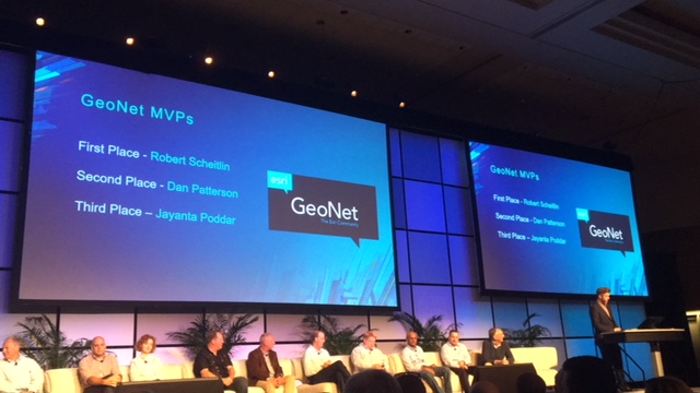
GeoNet Awards: 2017 Top Contributors
Earlier this year we recognized the top GeoNet contributors Jayanta Poddar, Dan Patterson, and Robert Scheitlin, GISP, and it was exciting to give them a well-earned shout out at UC, too.
|
|
|
| ||
The Road Ahead
Jack talks a little more about the Framework of The Science of Where and how Web GIS is driving digital transformation.
Conference Observations
- Real Experiences
- Community GIS (New and Unexpected Connections)
- Inspirational Maps
- Analysis Workflows and Tradecraft
- Energetic Interactions
- Users teaching users
UC Facts & Stats
- 17,901 attendees
- 2,200+ Esri Staff
- 142 countries
- 307 Exhibitors
- 600+ students
- A special shout-out to the Student Assistant program. This program plays a crucial role throughout UC and in starting and further GIS careers after the event. You can get involved and learn more about it here
- 1,100+ Young Professionals
- 108 Expo Spotlight Talks
- 34 Plenary speakers
- 480 Technical workshops
- 124 Special Interest Groups
- 237 Demo Theaters
- 198 Paper Sessions
- 1,700+ Maps (Map Gallery)
- 580 runners (Esri 5K)
- 105,600 buttons (Did you get your GeoNet button?)
- 5,500+ Gallons of Water
- 4,000+ Boxes of Water
- 2,400+ Gallons of coffee
- Total Live Hours Viewed 4,800 hours
- Lots of Inspiration and Enthusiasm
- Many success cases
- Many lifelong connections
- Future GIS-ers
- Many Lifelong learners!
What we can do better
- Inclusive Policies for families
- More childcare
- Growing conference
- Crowded map gallery
- More food trucks
- Better audio quality in demo theatres
- More charging stations
- Want Additional Expo Hours
- An earlier release of agenda
- Better navigation of the conference
- Dynamic room changes
- Wifi performance
- Better communication around submitted papers
- Need more Ad Hoc meeting spaces
Special Announcement
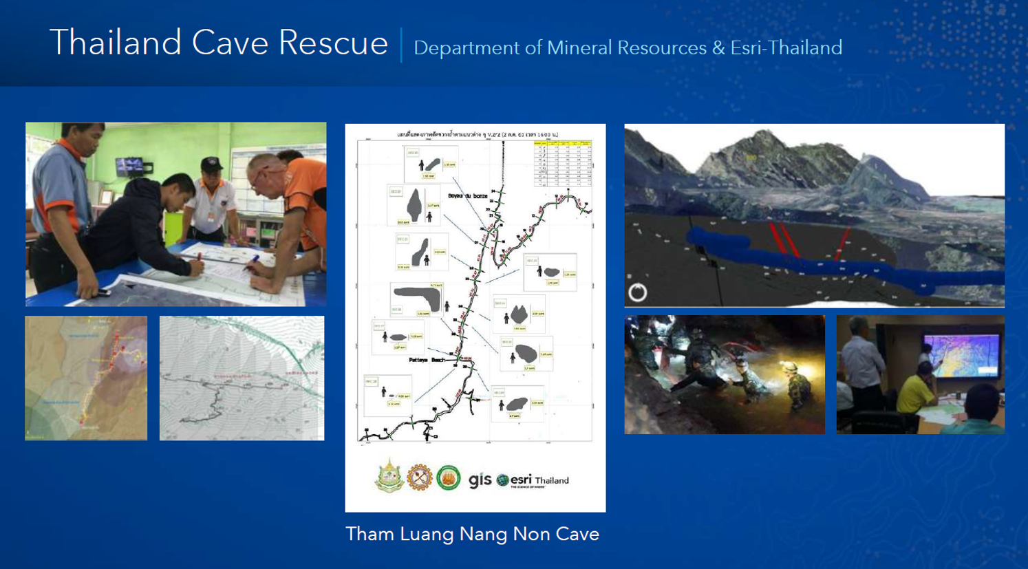
While we were at UC, Thailand made their amazing rescue of the students trapped in the cave.
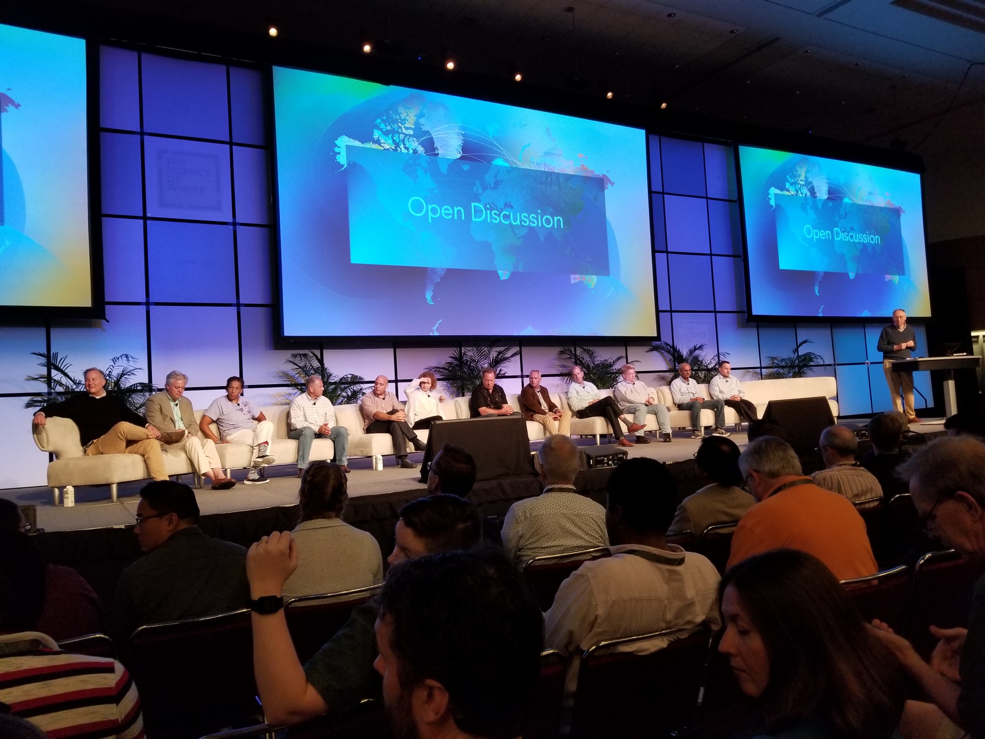 Q&A - Open Discussion
There was a lot of applause and many great questions and suggestions that came from the audience members. The best question was from an audience member that asked if Jack would wear a MapMan costume for the 50th Anniversary at UC next year. Jack responded by saying that his team should also wear one.
Jack's Closing Remarks
Jack praised his team, the organization, and the people that make Esri happen and make the difference for the customers, users and the community. Jack thanks everyone once more. Next year will be 50 years for Esri. Be sure to attend the User Conference. It will be a big one.
Thanks so much for following along! And a big thanks to all the guest contributors (Amy Niessen, Adena Schutzberg, Joseph Kerski, Kirsten Pinkston, Kory Kramer, Katie Cullen, Scott Prindle, Thomas Edghill, and many others) who shared their experiences with us throughout the week. It was great to partner with you this year and expand the coverage and perspective of UC 2018.
We hope you enjoyed UC 2018! We look forward to hearing what you've learned and what your biggest takeaways were from this year's event. Let's continue the conversation in the User Conference space and in the comments below!
You must be a registered user to add a comment. If you've already registered, sign in. Otherwise, register and sign in.