- Home
- :
- All Communities
- :
- User Groups
- :
- US Disaster Community
- :
- Questions
- :
- Re: Tropical Storm Barry
- Subscribe to RSS Feed
- Mark Topic as New
- Mark Topic as Read
- Float this Topic for Current User
- Bookmark
- Subscribe
- Mute
- Printer Friendly Page
Tropical Storm Barry
- Mark as New
- Bookmark
- Subscribe
- Mute
- Subscribe to RSS Feed
- Permalink
- Report Inappropriate Content
NAPSG Situational Awareness Viewer is available for anyone looking to monitor active incidents. The current extent has been set to the region currently forecasted to be impacted by tropical activity in the gulf.
Access the viewer: https://arcg.is/v0a8z 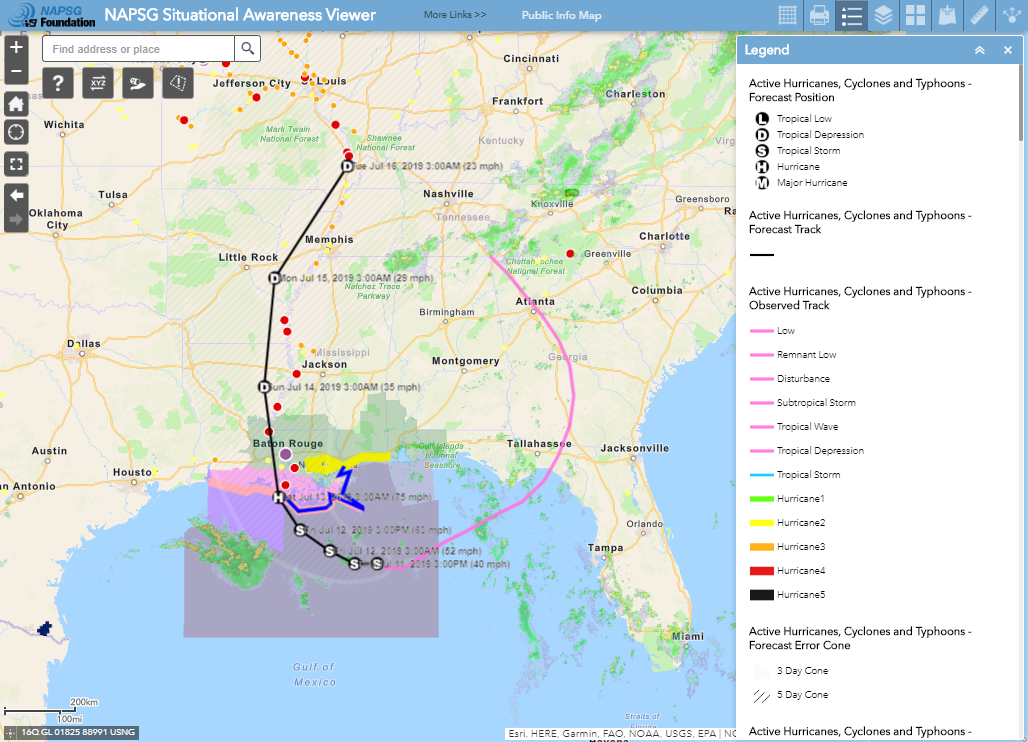
A number of Base Datasets as well as Live feeds (examples below) have been pre-configured in the Viewer.
NOAA National Hurricane Center (NHC) - Active Hurricanes, Cyclones and Typhoons - Forecast Position, Active Hurricanes, Forecast Track, Observed Track, Forecast Error Cone, and Watches and Warnings
FEMA / Red Cross - National Shelter System (Open Shelters)
NOAA / NWS - Storm Reports, Radar, USA Short-Term Weather Warnings, Long-Term Weather Warnings
USGS - Action Level Stream Gauges
- Mark as New
- Bookmark
- Subscribe
- Mute
- Subscribe to RSS Feed
- Permalink
- Report Inappropriate Content
FEMA has updated their Helpful Links Page for Tropical Storm Barry on the GeoPlatform.
Any public-facing Data sources listed here will also be included in the Updated Data Source documents sent to Remote Sensing and GIS Data for Disaster Community subscribers.
- Mark as New
- Bookmark
- Subscribe
- Mute
- Subscribe to RSS Feed
- Permalink
- Report Inappropriate Content
- Mark as New
- Bookmark
- Subscribe
- Mute
- Subscribe to RSS Feed
- Permalink
- Report Inappropriate Content
FEMA is updating the following Dashboards and made publicly available:
Energy Dashboard: https://fema.maps.arcgis.com/apps/opsdashboard/index.html#/94c12a14af6a43bd9f1bf1ddbfa44889
Transportation Dashboard:
https://fema.maps.arcgis.com/apps/opsdashboard/index.html#/0afb16f9b3f94ae48e4d710cfe735041
Additional FEMA GIS Links:
FEMA Public Data site:
http://disasters.geoplatform.gov/publicdata/NationalDisasters/2019/TropicalStormBarry_July2019/
FEMA GIS Portal:
https://fema.maps.arcgis.com/apps/MinimalGallery/index.html?appid=6bd1d3fa669343eb87bf7a8a15f028c0
FEMA HQ Hurricane Incident Journal:
https://fema.maps.arcgis.com/apps/MapJournal/index.html?appid=97f53eb1c8724609ac6a0b1ae861f9b5
PNNL Web service: (Flood Modeling Analysis)
https://www.arcgis.com/home/item.html?id=fb3cd10a72e04de4a8efb71badd8165b
Data is available for download here:
http://disasters.geoplatform.gov/publicdata/NationalDisasters/2019/TropicalStormBarry_July2019/Data/...
- Mark as New
- Bookmark
- Subscribe
- Mute
- Subscribe to RSS Feed
- Permalink
- Report Inappropriate Content
National Insurance Crime Bureau (NICB)/Geospatial Intelligence Center (GIC) post-incident imagery
When available, aerial imagery in support of Hurricane Barry will be made available here:
https://maps.geointel.org/server/rest/services/gray_sky_2019_barry.
To register for access, please contact credentials@geointel.org or visit www.geointel.org for more information.
Data Use Guidelines: This imagery is for access and use by GIC Members and credentialed public safety stakeholders. For those members and stakeholders, this imagery may be used with any online mapping website and/or enterprise GIS provided secured to that member or stakeholder organization. Members or stakeholders may use this imagery with printed and/or digital maps shared with customers and/or the public. Please credit the source of the imagery to “NICB/GIC”. This imagery is not to be available to the public via unsecured online mapping websites.
barry imagery #disasters
- Mark as New
- Bookmark
- Subscribe
- Mute
- Subscribe to RSS Feed
- Permalink
- Report Inappropriate Content
The GIC activated to Level 3 – Enhanced Monitoring on 10-Jul-2019 for Potential Tropical Cyclone 2 which would eventually become Hurricane Barry. On 15-July GIC stood-down and returned to Level 4 – Monitoring.
Following 5 days of monitoring for damage assessments, soliciting input from GIC insurer members, and coordinating with FEMA, NOAA, and other federal and state emergency management, this storm has not triggered thresholds established in the GIC Gray Sky Playbook for activation for imagery collection. The playbook calls for activation for imagery collection for hurricanes of Category 2 and greater or in special circumstances for Category 1.
Given low damage and utility for our insurer members, GIC did not collect imagery for Barry.
Thanks,
Richard Butgereit
Director of Catastrophe Response
Geospatial Intelligence Center
<mailto:richard.butgereit@geointel.org> richard.butgereit@geointel.org
850-591-2694