- Home
- :
- All Communities
- :
- Industries
- :
- Transportation
- :
- Transportation Questions
- :
- Re: How do I create a boundary points layer with u...
- Subscribe to RSS Feed
- Mark Topic as New
- Mark Topic as Read
- Float this Topic for Current User
- Bookmark
- Subscribe
- Mute
- Printer Friendly Page
How do I create a boundary points layer with updated Highway Postmile values?
- Mark as New
- Bookmark
- Subscribe
- Mute
- Subscribe to RSS Feed
- Permalink
- Report Inappropriate Content
I have a polyline layer for State Highways and a polygon layer of Urban Areas. I need to create a points layer where the highways intersect the boundaries of the Urban Areas.
Also, the highways layer has Postmile values in it. When I create the "boundary points" layer, I need to have updated Postmile values.
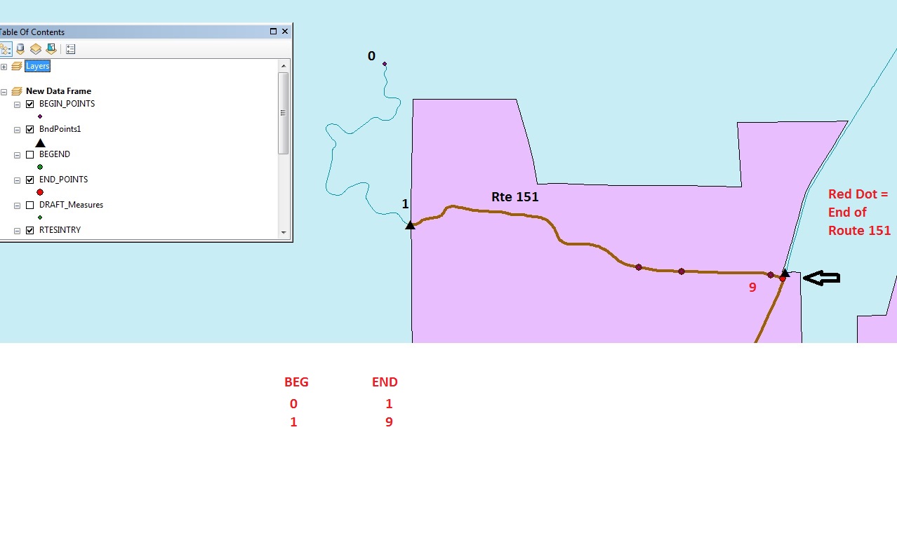
For example: If I have a Highway with Begin Postmile = 0 and End Postmile = 19, if the Highway intersects the boundary of the Urban Area at 6, then my Points layer should have fields looking like this:
BEGIN END
0 6
6 10
I have done something similar using another software but I'd like to think its simpler in ArcGIS.
Thanks,
Dan B
- Mark as New
- Bookmark
- Subscribe
- Mute
- Subscribe to RSS Feed
- Permalink
- Report Inappropriate Content
You might want to take a look at linear referencing for your highway layer.
- Mark as New
- Bookmark
- Subscribe
- Mute
- Subscribe to RSS Feed
- Permalink
- Report Inappropriate Content
Joe,
Please see attached. I was able to split segments for the Routes into
Urban and Rural sections and was able to Aggregate the Route segments, but
the problems now are how to have the correct begin/end measures at the
intersection points (created intersection points with other software).
Thanks,
Daniel Brenner
- Mark as New
- Bookmark
- Subscribe
- Mute
- Subscribe to RSS Feed
- Permalink
- Report Inappropriate Content
Locate Features along Routes is manual and not efficient for what I need
help with.
If I can aggregate segments and then break them up into Urban and Rural
Segments, I am 2/3 of the way there.
What I need to do is re-calculate (Calibrate?) the routes so that the
Begin/End measures are for the segments from begin-end from Boundary
INTERSECTION POINT TO BOUNDARY INTERSECTION POINT.
How do I get the Routes layer to do this ?
When I found out how to split the lines between rural and urban areas, the
fields that came up were for the Cities boundary layer or ? and not for the
Polyline layer (postmiles).
Thanks,
Daniel T. Brenner
RESEARCH ANALYST I (GEOGRAPHIC INFORMATION SYSTEMS)
DIVISION OF RESEARCH, INNOVATION, and SYSTEM INFORMATION
Highway System Information and Performance
1120 N Street MS 38
Sacramento, CA 95814
(916) 657-4277
(510) 593-7547 cell
daniel.brenner@dot.ca.gov
“Consider the unconsidered.”
“Certainty is not a sure thing!”
- Mark as New
- Bookmark
- Subscribe
- Mute
- Subscribe to RSS Feed
- Permalink
- Report Inappropriate Content
I think there is an easy answer to this. You can use the tool "Locate Features on Route" to generate an event table like you describe. Locate Features Along Routes—Help | ArcGIS for Desktop
After you create the event table you can render it as points using the Begin measure. You could also render it as line events using both the BEGIN and END measures.
If your polyline is not currently a route (it has measures (M values) on the coordinates) then you can turn it into a route using the "Create Routes" tool. Create Routes—Help | ArcGIS for Desktop
- Mark as New
- Bookmark
- Subscribe
- Mute
- Subscribe to RSS Feed
- Permalink
- Report Inappropriate Content
Tom,
Thank you for this, I will give it a try, but the heart of the matter is that once I was to/would be able to create new routes based on this tool, how can I get the correct Postmile Values at where the line intersects the boundary of the polygon?
(imagine 5 and 10 as polygon borders)
BEG END
0 5
5 10
10 15
0----------------------------------5\---------------------------10\------------------------15
- Mark as New
- Bookmark
- Subscribe
- Mute
- Subscribe to RSS Feed
- Permalink
- Report Inappropriate Content
Daniel,
That's where the Locate Features along Routes tool comes in. Check out the documentation on it in the link from my previous post. It does exactly what you are looking for. At lest I think it does.
Tom
- Mark as New
- Bookmark
- Subscribe
- Mute
- Subscribe to RSS Feed
- Permalink
- Report Inappropriate Content
Tom,
I know you're doing what you can, but for now look at my attachments again:
Forget that I used another software to create a Points layer of boundary
points (where the polyline intersects the polygon boundary).
The illustrations show the differences between what I have right now (a
polyline layer with a number of segments with individual measurement
values) and what I need (a polyline layer of one segment length.
For now, I have used Linear Referencing tools but I am only getting the
current begin and end points of each segment; I need to have the values
based on where the polyline intersects the polygon boundary---ideally with
an automated procedure.
I essentially have a 3 part procedure for a segments layer that has 2500
segments:
1) A polyline feature that has segments with measurements. I need to
aggregate the segments into one segment with a total length of X?
2) Break the newly aggregated polyline find the (new) point measures for
where the new polyline segment intersects the boundary of the polygon .
3) My points layer database needs to have fields indicating the prior
segment's Begin Point and the End point values.
*****************
I have tried the tools in Linear Referencing, but haven't been able to find
the tool/tools that work. For example, the one tool that aggregates the
segments doesn't give me the fields I need--Begin and End point measures
for the segments, just the ID fields for the polylines (??).
Hope this helps.
Daniel Brenner
- Mark as New
- Bookmark
- Subscribe
- Mute
- Subscribe to RSS Feed
- Permalink
- Report Inappropriate Content
Daniel,
I have looked at your illustration again and I am sticking with my recommendation. Here is the process I recommend.
1. Create Linear Referencing routes out of your segments. Use the Create Routes tool that I mentioned before for this. For the "measure_source" you will use the TWO_FIELDS option and specify the two fields in your segments that have your from and to measures. This will produce a linear referencing routes where the coordinates have the measure values (x,y,m). Your measures will not be displayed in fields like they are in the segments because they are stored on the coordinates. You can use this route layer for other linear referencing functions.
2. Use the Locate Features Along Routes tool to overlay your Polygons onto the routes you created in step 1. The polygon layer will be your "in_features" and he route layer will be your "in_routes". The result of this will be a table that has the route ID as well as a From and a To measure field. The From Measure field will have the first measure where the polygon touches the route and the To measure will be the second.
3. In ArcMap or ArcGIS Pro use the Make Route Event Layer tool. For your route features you will use the routes you created in step #1 and for the Input Events you will use the table that was created in step #2. You will create point events using the To Measure field that you specified in step #2. The result will be an point layer that will have the measure that the polygon instersected the routes as well as a From Measure (Begin Point) where the polygon first intersected the routes. If you want an actual point dataset you can export this layer out to a new feature class.
Another option is to render the events as lines with the from and to measure but that is not what you originally asked for.
I hope this helps.
Tom
- Mark as New
- Bookmark
- Subscribe
- Mute
- Subscribe to RSS Feed
- Permalink
- Report Inappropriate Content
Joe:
It is 10:40 am PST as I write and I will be in the office in the next hour
or so. What Time Zone are you in?
Daniel Brenner