- Home
- :
- All Communities
- :
- Industries
- :
- Transportation
- :
- Transportation Questions
- :
- ArcGIS Pro 2.3.0 asigning Spatail Reference to my ...
- Subscribe to RSS Feed
- Mark Topic as New
- Mark Topic as Read
- Float this Topic for Current User
- Bookmark
- Subscribe
- Mute
- Printer Friendly Page
ArcGIS Pro 2.3.0 asigning Spatail Reference to my Spatial data
- Mark as New
- Bookmark
- Subscribe
- Mute
- Subscribe to RSS Feed
- Permalink
- Report Inappropriate Content
Hello everyone,
As I'm new to esri this is probably a simple answer or someone can just point me to some help files already created.
As I've only started a few months ago, I'm purely in ArcGIS Pro 2.3.0. I have data from my GIS group stored in Oracle > GeoMedia server structure with our UTM "Extended" zone 13N spatial. when I add this data to a new map it doesn't recognize the Spatial Reference.
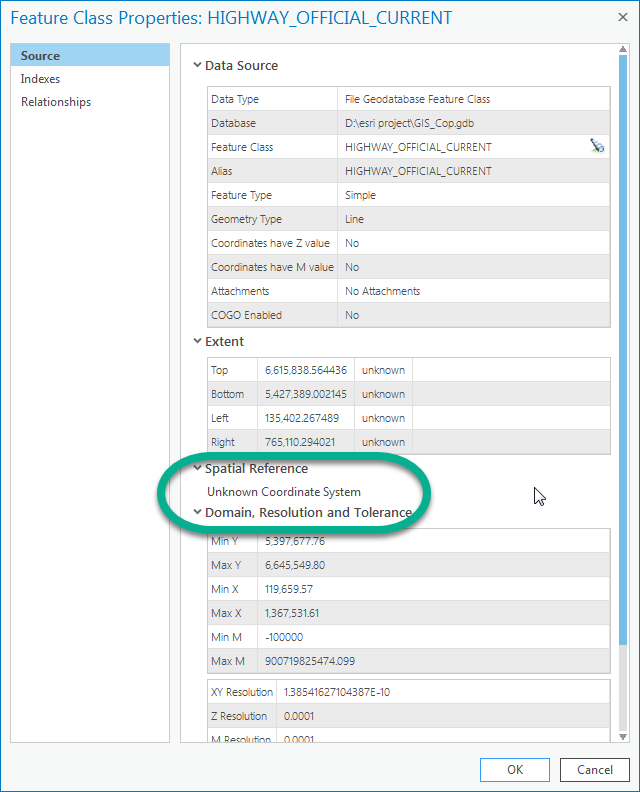
I'm making a copy of the data to my local GISCopy.gdb, and was wondering if I can convert the GPS set esri to remember my database settings on each new map?
I've read you used to do this in Arc Catalog, but I don't seem to have that installed.
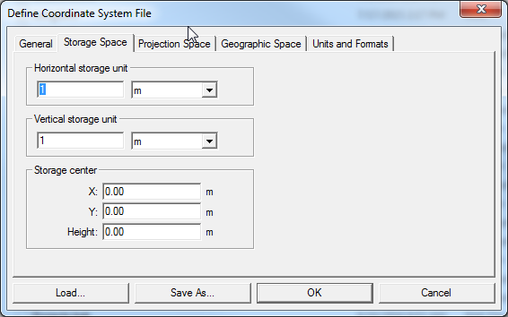
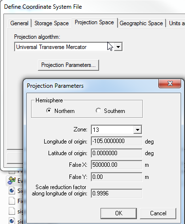
I have attached an Intergraph .csf file containing my spatial settings if this helps. I also have SAFE FME now if there is a solution.
- Mark as New
- Bookmark
- Subscribe
- Mute
- Subscribe to RSS Feed
- Permalink
- Report Inappropriate Content
Hi Trevor,
I'm a product engineer who focuses on coordinate reference systems (CRS).
The csf file appears to be in a binary format and I don't have access to Geomedia or Oracle. We don't have a coordinate system called UTM "Extended" zone 13N.
Since you're working with a file geodatabase, you can use the Define Projection Tool to assign a CRS to the data, or at least to the map/scene. Can you screenshot the coordinate system information from Geomedia so I can point you towards a similar/equivalent definition or how you would go about creating a custom CRS?
I suspect that it's EPSG:2957, NAD83(CSRS) / UTM zone 13N or EPSG:26913, AD83 / UTM zone 13N.
Thanks,
Melita
- Mark as New
- Bookmark
- Subscribe
- Mute
- Subscribe to RSS Feed
- Permalink
- Report Inappropriate Content
Hi Kennedy,
Thank you, this tool seems to work, however it seems to let me define features in my map, but not set the database itself. Do I need to convert my data and then export it to a .gdb?
Something like this:
1. Import data
2. "Define projection"
3. Export to my .gdb
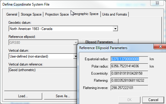
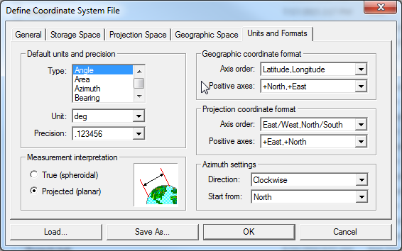
Let me know if I picked the correct CRS; here are the settings from my .csf file
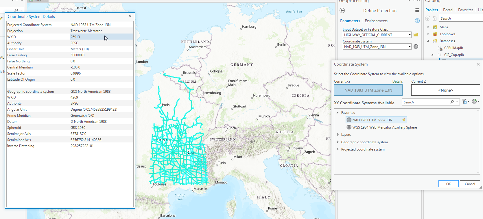
At the bottom I included the "NAD 1983 UTM Zone 13N" I selected "WKID 26913"
.csf windows in order:

My selection in ArcGIS Pro to bring my highways back to Canada:
- Mark as New
- Bookmark
- Subscribe
- Mute
- Subscribe to RSS Feed
- Permalink
- Report Inappropriate Content
Update, RESOLVED
After fighting with this for a couple months I found out our GIS groups oracle database uses Spatial format from before version 8.1.6. They have null value for the zone in SDO_GEOMETRY. I was able in FME tell it what zone I wanted and exported it into a GeoDatabase successfully.
Really love the power of esri and how all other software accepts the standards so easy. Currently working with data in portal, SQL, SQL Spatial, Oracle, Shape, Excel, MS Access, and GeoDatabases.