- Home
- :
- All Communities
- :
- Industries
- :
- State & Local Government
- :
- State & Local Government Questions
- :
- Re: Some FAQs I had about the Citizen Problem Repo...
- Subscribe to RSS Feed
- Mark Topic as New
- Mark Topic as Read
- Float this Topic for Current User
- Bookmark
- Subscribe
- Mute
- Printer Friendly Page
Some FAQs I had about the Citizen Problem Reporter Solution
- Mark as New
- Bookmark
- Subscribe
- Mute
- Subscribe to RSS Feed
- Permalink
- Report Inappropriate Content
I have spent some time this month trying to understand how the Citizen Problem Reporter solution works There are a lot of basic questions I had that I couldn't find answers to on the Get Started page or elsewhere on the world wide web.
I thought I'd share some of the answers I've figured out with the automated deployment of the Citizen Problem Reporter Solution and see if anyone else has other questions/solutions!
Question | Answer | ||||||||||||||||||||||||||||||||||||||||||||||||||||||||||||||||||||
Why do I only see "Configured group is invalid or no items have been shared with this group yet." on my Reporter application? | This has to do with the fact that the configured group does not contain at least one map with at least one editable layer that is accessible to the current user. If the group does contain an editable map with an editable layer, then check the sharing. It may be that you haven't updated the sharing of the group or if you have, perhaps you are not Signing In with the proper account -- Sign in with ArcGIS if it isn't shared publicly. I kept trying to sign-in as Guest longer than I care to admit. | ||||||||||||||||||||||||||||||||||||||||||||||||||||||||||||||||||||
Why can't I see the image tab on a selected report in the Citizen Problem Manager? | This tab is only visible when the selected report contains at least one image attachment, or images and charts defined as part of the popup configuration. | ||||||||||||||||||||||||||||||||||||||||||||||||||||||||||||||||||||
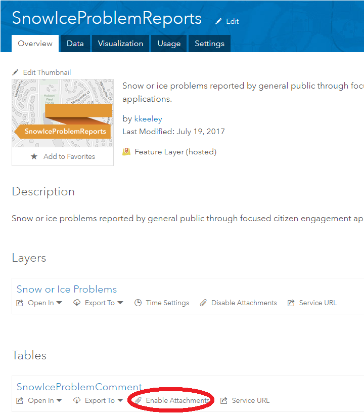
Why can't the user attach photos to reports? | Attachments aren't enabled. When you do this process automatically, the layers are automatically uploaded to AGO. The attachment section of the form where photos and other supporting files can be added to the report is only available when attachments are enabled on the layer. This can be easily done by going to the feature layer in AGO and clicking "Enable Attachments".
| ||||||||||||||||||||||||||||||||||||||||||||||||||||||||||||||||||||
How do I add fields in the form of the Reporter? |
| ||||||||||||||||||||||||||||||||||||||||||||||||||||||||||||||||||||
How do I delete fields in the form of the Reporter? | Open ArcGIS Pro. Add the Report Layer or Comment Table that the field is located in | ||||||||||||||||||||||||||||||||||||||||||||||||||||||||||||||||||||
How do I turn off fields in the form of the Reporter? | If you don't want to display a field, but you aren't ready to delete it, go to the AGO web map that the layer is on. Go to Configure Pop-Up and then click Configure Attributes and just uncheck the Display. | ||||||||||||||||||||||||||||||||||||||||||||||||||||||||||||||||||||
Why can't the user edit the fields in the form? | First, when you are creating the field in the Configuration Task via ArcGIS Solutions, it's vital that you give the field a Field Length. The other issue may be that editing isn't enabled on the layer or in the pop-up. When you are in the AGO web map, Configure Pop-Up and then click Configure Attributes and ensure that the Editing box is checked in addition to the Display check box. | ||||||||||||||||||||||||||||||||||||||||||||||||||||||||||||||||||||
How can manipulate how every report/comment looks? | As far as I can't tell, you can't change the look of the form itself. However, once the report/comment is posted, you can change how this looks. This again happens in the AGO Web Map layer pop-up. When you go to Configure Pop-Up you have a few options. Under Pop-up Contents --> Display dropdown, change it to A custom attribute display --> then CONFIGURE. Here, you can add your own text and pull information from the report/comment fields (by clicking the + box; see image below). Scroll to the bottom where it says Pop-up Media. Here you can add a standard image/chart to all of the posted reports/comments. | ||||||||||||||||||||||||||||||||||||||||||||||||||||||||||||||||||||
How do I change colors and text in the Reporter? IMPORTANT NOTE: it is highly recommended that when these changes are made to Reporter maps/layers/applications, they are also made to the respective maps/layers/applications in the Manager for consistency and clarity purposes. |
|

Do you have other solutions or questions? I'd love to hear them!
- Mark as New
- Bookmark
- Subscribe
- Mute
- Subscribe to RSS Feed
- Permalink
- Report Inappropriate Content
Hi Bill,
The solution leverages a capability not currently available in Enterprise (hosted feature layer join views). When this capability is added to Enterprise we will be able to support the solution in that version of Enterprise.
- Mark as New
- Bookmark
- Subscribe
- Mute
- Subscribe to RSS Feed
- Permalink
- Report Inappropriate Content
Thanks Chris, I'm trying it out in AGOL, hopefully Enterprise will catch up soon!
- Mark as New
- Bookmark
- Subscribe
- Mute
- Subscribe to RSS Feed
- Permalink
- Report Inappropriate Content
Is there a way to make the existing fields that were provided required?
- Mark as New
- Bookmark
- Subscribe
- Mute
- Subscribe to RSS Feed
- Permalink
- Report Inappropriate Content
Hi Rachel,
The city I work for has just started implementing this solution in our community. They wanted email and phone number to be required. The easiest work around I found was to create new fields,{email} {Phone_Number}), BEFORE I created any new views and set them to Not Allow null values. This made them required. Just be warned people can simply but in a few characters if they wanted to get around the requirement without putting any real info in those fields but so far we haven't had too many issues.
- Mark as New
- Bookmark
- Subscribe
- Mute
- Subscribe to RSS Feed
- Permalink
- Report Inappropriate Content
If you have arcade / html code in the pop-up for a custom display, will it honor that in the application form? I.e., If someone selects "municipality" from a dropdown, can I have the following fields changed based on their selection (for example, the question about being the homeowner disappears if a municipality is submitting the form.)
I have some of that for the manager map so that when a report status is changed to "Completed," a new field appears on the pop-up calculating how long it took to resolve the report for QC target purposes.
- Mark as New
- Bookmark
- Subscribe
- Mute
- Subscribe to RSS Feed
- Permalink
- Report Inappropriate Content
When I make my next version of citizen problem reporter I am going to be using Experience builder.
I need to have custom forms where when a certain answer makes other questions appear. The only way I know of doing this is with Survey123.
There is a way to use Survey123 in Experience builder
Survey widget—ArcGIS Experience Builder | Documentation
Survey123
- Mark as New
- Bookmark
- Subscribe
- Mute
- Subscribe to RSS Feed
- Permalink
- Report Inappropriate Content
Kate,
Thank you, this post was very helpful. Do you by chance know if it is possible to change the basemap in the reporter application? I was able to add a web map as a basemap to my "Basemap Gallery" but is there a way to only give one option instead of the gallery? Also, when doing so, I attempted to load a city boundary layer to show where the city limits are with the basemap (webmap) but only the Hybrid Reference Layer and World Imagery layer show.
Any thoughts or advice would be greatly appreciated! 🙂
- Mark as New
- Bookmark
- Subscribe
- Mute
- Subscribe to RSS Feed
- Permalink
- Report Inappropriate Content
Looks like this is a pretty old post, but giving my question a shot any how.
Any idea how I can keep the attachments turned on for citizens to submit pictures, but then remove them from the pop up so that the public can't see the pictures?
- « Previous
- Next »
- « Previous
- Next »