- Home
- :
- All Communities
- :
- Industries
- :
- State & Local Government
- :
- State & Local Government Questions
- :
- Point services not showing in My Goverment Service...
- Subscribe to RSS Feed
- Mark Topic as New
- Mark Topic as Read
- Float this Topic for Current User
- Bookmark
- Subscribe
- Mute
- Printer Friendly Page
Point services not showing in My Goverment Services 10.2
- Mark as New
- Bookmark
- Subscribe
- Mute
- Subscribe to RSS Feed
- Permalink
- Report Inappropriate Content
We up graded our ArcGIS server to 10.2.2 so we had to upgrade our My Government Services app to the newest version. Since doing that none of our point services like Library, Fire Stations etc will show up in the map and the pods at the bottom are empty. All the data is coming from the same feature service and the polygon features query just fine. It seems like it might be related to the geometry service as I am also having problems with the locate button at the top of the app not working either.
We had a working app (version 10.1 and same services) on our website but now it's broken and since we upgraded our server we can't go back to the old version of the app. I have been working with Esri tech support for the last two weeks but we have not been able to resolve the issue so I could really use some ideas on where to look for problems. Thanks!
- Mark as New
- Bookmark
- Subscribe
- Mute
- Subscribe to RSS Feed
- Permalink
- Report Inappropriate Content
Hi Shawny,
Can you post a URL to the application? It would help to see what errors are being reported in the console.
- Mark as New
- Bookmark
- Subscribe
- Mute
- Subscribe to RSS Feed
- Permalink
- Report Inappropriate Content
Here is the url for the app:
- Mark as New
- Bookmark
- Subscribe
- Mute
- Subscribe to RSS Feed
- Permalink
- Report Inappropriate Content
It's not public yet. We are still working on setting all of that up. Sorry
- Mark as New
- Bookmark
- Subscribe
- Mute
- Subscribe to RSS Feed
- Permalink
- Report Inappropriate Content
Hi Shawny,
According to FireBug, It looks like your URL is incorrect:
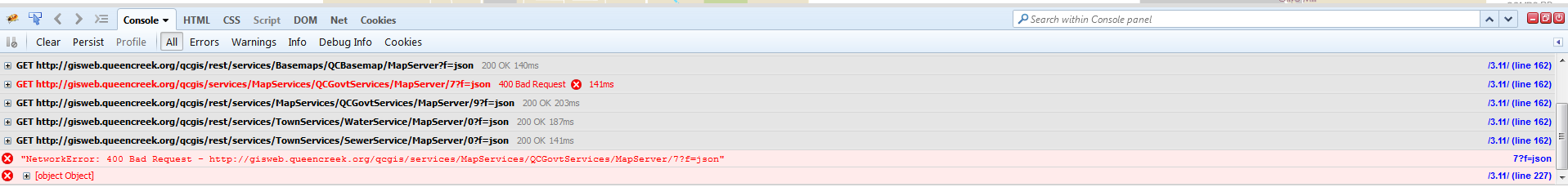
It appears you have the following:
http://gisweb.queencreek.org/qcgis/services/MapServices/QCGovtServices/MapServer/7
'rest' is missing in the URL. You will want to change this to:
http://gisweb.queencreek.org/qcgis/rest/services/MapServices/QCGovtServices/MapServer/7
Be sure to check the other URLs to your REST services to make sure they are correct as well.
- Mark as New
- Bookmark
- Subscribe
- Mute
- Subscribe to RSS Feed
- Permalink
- Report Inappropriate Content
Oddly enough that is one of the layers that actually works!
I have since started over with a new test app and now am getting this error message which points back to the geometry service, I just don't know what it means.
{error: {code: InternalServerError,message:"Unable to connect to the remote server http://gisweb.queencreek.org/qcgis/rest/services/Utilities/Geometry/GeometryServer/buffer?f=json&unit=9093&unionResults=false&geodesic=true&geometries=%7B%22geometryType%22%3A%22esriGeometryPoint%22%2C%22geometries%22%3A%5B%7B%22x%22%3A%22-12427143.560249703%22%2C%22y%22%3A%223927827.406217205%22%2C%22spatialReference%22%3A%7B%22wkid%22%3A102100%2C%22latestWkid%22%3A3857%7D%7D%5D%7D&inSR=102100&distances=4&outSR=102100&bufferSR=4326"}}
- Mark as New
- Bookmark
- Subscribe
- Mute
- Subscribe to RSS Feed
- Permalink
- Report Inappropriate Content
It seems like this could be one of a couple issues...
Since it is saying it can't connect to a server... have you checked:
- Your Proxy (if you're using one)
- Your WebAdaptor (did it get upgraded as well?) : DOCUMENTATION
- Your MXD (have you re-shared it as a service?)
This assumes you did what we did. Collect almost all layers (except ones utilized by other web maps) into a single MXD and publish it as a service. - Your IT Firewalls (We had all sorts of fun with the web guys restricting certain protocols, ports, etc.)
This is where I would start.
- Mark as New
- Bookmark
- Subscribe
- Mute
- Subscribe to RSS Feed
- Permalink
- Report Inappropriate Content
Hey Shawny
How did you get this solved? I noticed when I went to your link that it is working now. Also if you'd like, you can zoom in further to the map by changing the zoom level to 15.
I'm having the same issue you did and all my urls are correct.
Thanks!
Daniel M
- Mark as New
- Bookmark
- Subscribe
- Mute
- Subscribe to RSS Feed
- Permalink
- Report Inappropriate Content
I feel like each solution should have it's own group.
We propped up the app and had no end of minor issues. After it was all said and done the problems we dealt with were laughable, but hindsight makes many things ridiculous. lol
http://maps.cityoftulsa.org/tulsacommunityservices
What problems are you having?
- Mark as New
- Bookmark
- Subscribe
- Mute
- Subscribe to RSS Feed
- Permalink
- Report Inappropriate Content
I can't access the REST service for Street Cleaning.
Are these shared publicly?