- Home
- :
- All Communities
- :
- Industries
- :
- State & Local Government
- :
- State & Local Government Questions
- :
- Re: Hi, I'm a newbie attempting to build a fire se...
- Subscribe to RSS Feed
- Mark Topic as New
- Mark Topic as Read
- Float this Topic for Current User
- Bookmark
- Subscribe
- Mute
- Printer Friendly Page
Hi, I'm a newbie attempting to build a fire service map book. What inputs are necessary?
- Mark as New
- Bookmark
- Subscribe
- Mute
- Subscribe to RSS Feed
- Permalink
- Report Inappropriate Content
Hi guys, a mapping newbie/volunteer fire officer here. I'm attempting to create a fire run book using the "Fire Service Maps" add-on on ArcGIS PRO 2.2. Some really basic stuff is stumping me already.
I did procure parcel outlines and Streets shapefiles from the county, but I don't know when/where to use them. I'm going through the tasks and I'm at "Load data into SiteAddressPoint feature class". Here's what it's giving me the option of doing:
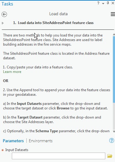
I suppose I could just forge forward and try to see if the streets shapefile is able to be pulled in here, but I thought it'd be better if I asked first. And when should I import the parcel outlines shapefile?
Sorry for the newb question. (And I'm sure I'll have more to come!)
Thanks!
- Mark as New
- Bookmark
- Subscribe
- Mute
- Subscribe to RSS Feed
- Permalink
- Report Inappropriate Content
Hey, you started answering my follow-up question before I even asked it! Nice!
Andy yes, I would really love to be able to align my own polygons, because as you point out, the grids automagically chosen are never optimal- breaking up small neighborhoods and major intersections as if it was its mission.
As I am a GIS novice, I guess I will have some learning to do to create my own grid/polygons.... I guess I have some time while I wait for the "Create run book" process to be fixed!!!
- Mark as New
- Bookmark
- Subscribe
- Mute
- Subscribe to RSS Feed
- Permalink
- Report Inappropriate Content
Thanks much Brian! After a sleep-deprived weekend (I made the most of the extra hour!) I have pretty much everything lined up- I did, however, bomb in the run book creation due to what seems to be a know bug.
However, I AM very interested in creating a grid with different size squares like you have done- a smaller coverage area for more dense locales, and larger for rural-type tracts. As I noted above, I used the "grid index" tool to create my uniformly sized grid. Any info or insight you could pass along on how to do this would be greatly appreciated!
I will contact you offline....
I guess I get it that we are charged a nominal fee (3 cents per parcel) for the map data. Our 911 administrators don't know much about map data- I approached them first. In PA since we're a "home rule" commonwealth, we're actually a separate entity from the county who supplies dispatch and property services...
- Mark as New
- Bookmark
- Subscribe
- Mute
- Subscribe to RSS Feed
- Permalink
- Report Inappropriate Content
Hi Bucky,
Wow! Volunteer fire fighter and GIS! You are a person that I want to talk to. I'm a relatively new GIS staff member at the USFA at NETC in Emmitsburg. Sounds like you are near-by? I was reading your questions and responses with interest as I'm new to the structural fire fighting emergency response side of GIS and trying to also get transitioned over to Pro too. (I have used ArcGIS and QGIS for many years) I plan to follow up on some of these leads you have highlighted. Thank you for the thread. There might be some training resources for you here at NETC, and I would like to hear more about how you use GIS in your job. Don't know how best to connect, but if you could call or email, that would be awesome.
Cindy
(Cynthia.fowler@fema.dhs.gov 301-447-1837)
- Mark as New
- Bookmark
- Subscribe
- Mute
- Subscribe to RSS Feed
- Permalink
- Report Inappropriate Content
Best thing about this forum: networking!
- Mark as New
- Bookmark
- Subscribe
- Mute
- Subscribe to RSS Feed
- Permalink
- Report Inappropriate Content
Hi Cynthia! I'll give you a call sometime tomorrow. And for the record....I'm volunteer firefighter AND volunteer GIS. I am a career IT person, but this is my first foray into GIS- I got so sick of our outdated map books I decided to do something about it! It's been a long path though..anyone can stop reading now if they don't want to hear the lengthy story about how I ended up at this point...
Almost exactly two years ago I finally decided to do something with new map books. Ours were originally created in 1980, and updated in 1990. And since then it's all hand-edits and stuff like that. Oh, and the township did supply a new "map book" about ten years ago, but the scale is so bad and the objects so small it's virtually worthless. Everyone still uses the old map books (or google maps!) instead of that new book.
So I'm researching, going online, and I find Openmap. (or is it OpenGIS? I forget now!). Installed that and started messing around and got really frustrated. Upon further searching, I learned that ESRI had this pre-canned "Fire Run Book" thing. Perfect! But, alas, ArcMap was cost-prohibitive for my volunteer department. Then I found they had a non-profit program...great! Apply for it and...WOMP WOMP WAAA....it's only for 501c(3) organizations and not 501c(4), which we were. Apparently there has been talk over the years of us applying to be a 501c(3), but the paperwork requirements were too daunting so nobody ever followed through. Until me! I had to change the company charter (not an easy process) to match IRS requirements. Had to change the company bylaws. So those two steps took about 6 months. THEN I filled out all the very lengthy, very detailed IRS applications Another few months. Finally submit the application...
Then a couple months later...VIOLA! We're approved as a 501c(3)! I rush back to the ESRI site and submit our non-profit discounted license request...get it approved...install ArcMap...and start trying to figure stuff out. I go through a bunch of training modules on the Amazonian rainforest. Start in trying to build the map book. I wasn't really that far in at all when I realized I was missing some essential data. I wanted either the building footprints or parcel lines for my map. The only source I can see that had footprints was G**gle, and they apparently stopped providing their basemap. I recalled from looking at county real estate records that they have parcel lines...I find out where I can get them from, but unfortunately there's a charge. So I have to go back to the fire company and get that expense approved...then the request is submitted to the county. In the meantime some stuff happened in my personal life that started eating up all my free time for a period of about 4 months. So finally when I break free just last week, I find that the "Fire Run Book" on ArcMap has been succeeded by "Fire Service Maps" on ArcGIS PRO. I figure I'd better go with the new thing, so a little learning curve there...and finally, with the help of really cool folks here on geonet, I have a great start on the new map book! Only took two years from when I started the quest!!!
There's still lots and lots to figure out and tweak, so I figure I'm still a good couple months before the task it complete. But I'm fairly confident I'll get there- just a lot more of a learning curve to climb!!!
(As an aside, even though my fire company got its 501c(3) designation solely for this purpose*, it has paid LOTS AND LOTS of dividends over and above this. Many residents can now contribute to our fund drive via their employer's matching program; we participate in Amazon Smile and receive funds from that; my employer even offers a quarterly reward to the company once all my volunteer hours are documented. So it's made us thousands in additional funds already!!) (* I don't mean that literally- we merit the status- but if I hadn't wanted to get ArcGIS, nobody would've gone through the process to get it done!!)
- Mark as New
- Bookmark
- Subscribe
- Mute
- Subscribe to RSS Feed
- Permalink
- Report Inappropriate Content
This is the best story ever! I love it! I can't wait to see how the story unfolds, but it sounds like you truly demonstrate what public service is all about. I'm starting to learn more about that here at EMI surrounded by fallen hero tributes (and even some other heroes walking the halls.) I look forwarding to talking to you.
- Mark as New
- Bookmark
- Subscribe
- Mute
- Subscribe to RSS Feed
- Permalink
- Report Inappropriate Content
Hi Bucky,
Just checking in to where you stand with your map book. If you are on to something, maybe there is way we can develop some helpful steps that we could share with other volunteer fire departments? Sounds like from your description this is a common issue. I am wondering if there is something I could propose as a project for next year to the US Fire Admin? thanks
- Mark as New
- Bookmark
- Subscribe
- Mute
- Subscribe to RSS Feed
- Permalink
- Report Inappropriate Content
Hi Cynthia and everyone else! I suppose I owe everyone an update and an apology. As with all things volunteer, sometimes a work life or personal life (not to mention a weird spike in the number of fires!) gets in the way of progress. And that unfortunately has been the case for me recently.
So I've been working with Mary from support on getting the "final" generation step to work without failing. She has been working diligently to help. The last thing she's asked for I'm struggling to accomplish on my own. We are setting up a webex so she can walk me through it after the holidays, because unfortunately right now talking is painful for me (complications from wisdom tooth removal  ) and I am using my voice as sparingly as possible (the guys at the firehouse, I believe, are thankful for this while still giving the appearance of empathy
  ).
).
Anyhow, as I did the multi-iteration generation of an entire runbook, I've had the opportunity to take that in a truck and see how it fared in "real life" situations. Here's the initial takes on things that I need to improve before going live with this:
1- The index is built on the alphanumeric grid ("Pagename") but the notations on each page showing the adjoining map pages use the page number ("Pagenum"). And each individual page has its own "Page Name", but not "Page Number". So if for example the right (east) side of the map page you're looking at adjoins with page 35, there's no way to find page 35 short of counting each page starting at #1. It may be somewhat simpler to add the page number on each sheet along with the page name, but I think a much better method would be to stick with one (and only one) reference for each grid- either the alphanumeric grid name or the numeric page number. Not sure which would be better, but using both is confusing.
2. The index pages have a bug where long names overlap/overprint onto the corresponding index notation.
3. The index pages, as currently generated, aren't the easiest to read in a dimly lit fire truck bouncing down the road. Perhaps going to a single-column format with a larger, bolder font would fix this and #2 at the same time.
4. Likewise, the basemap I've chosen (black & white basemap) has smaller type and fonts for street names. So although my grids are fairly small/zoomed in, the street names are hard to read in the hardcopy/truck environment. I don't know if there really can be any fix for this short of finding a better basemap.
5. Lastly, some GREAT news: Our county GIS has a new coordinator and they are in the process of putting together a data portal where the data will be updated every two weeks or so (and for FREE!). Until the portal is in place, he is going to add me to an ArcGIS group so I can pull the data directly from the web. AND they have an initiative to get everything into the ESRI Local Government Information Model (LGIM) so in the future I won't have to go through all of the data massaging steps that I do now to get the data into the format where I can use the "Fire Service Maps" routines. And he's also very enthusiastic about getting what the fire service needs- things like hydrants, road obstructions, etc., may soon all be native to the county datasets so I won't have to go gather up these things from disparate sources. Things are looking up in that regard!
Anyhow, I apologize again for leaving everyone hanging. Hopefully soon things will return to a semi-normal state and I can resume progress on this project. Happy holidays to all!
- « Previous
- Next »
- « Previous
- Next »