- Home
- :
- All Communities
- :
- Industries
- :
- State & Local Government
- :
- State & Local Government Questions
- :
- Re: Hi, I'm a newbie attempting to build a fire se...
- Subscribe to RSS Feed
- Mark Topic as New
- Mark Topic as Read
- Float this Topic for Current User
- Bookmark
- Subscribe
- Mute
- Printer Friendly Page
Hi, I'm a newbie attempting to build a fire service map book. What inputs are necessary?
- Mark as New
- Bookmark
- Subscribe
- Mute
- Subscribe to RSS Feed
- Permalink
- Report Inappropriate Content
Hi guys, a mapping newbie/volunteer fire officer here. I'm attempting to create a fire run book using the "Fire Service Maps" add-on on ArcGIS PRO 2.2. Some really basic stuff is stumping me already.
I did procure parcel outlines and Streets shapefiles from the county, but I don't know when/where to use them. I'm going through the tasks and I'm at "Load data into SiteAddressPoint feature class". Here's what it's giving me the option of doing:
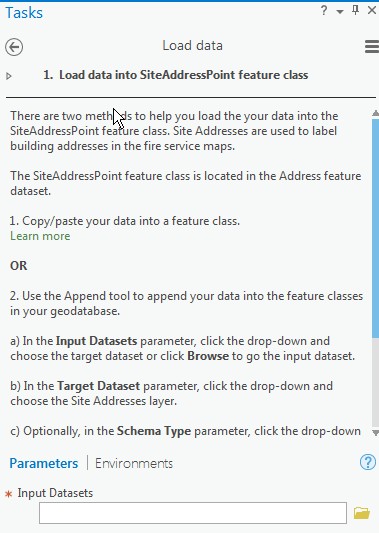
I suppose I could just forge forward and try to see if the streets shapefile is able to be pulled in here, but I thought it'd be better if I asked first. And when should I import the parcel outlines shapefile?
Sorry for the newb question. (And I'm sure I'll have more to come!)
Thanks!
- Mark as New
- Bookmark
- Subscribe
- Mute
- Subscribe to RSS Feed
- Permalink
- Report Inappropriate Content
Well, I ran Feature-to-Point and it resulted in a nifty layer as well as dots in the center of my parcels. Pretty cool!
However, I can't figure out how to import into LocalGovernment database that is deployed as part of the Solution/Project. The DB has a table/layer called "SiteAddresses" which is used to put the address of the parcel on its proper place within the map. Running the task to import the data, I try to import the dataset I created with "FeatureToPoint". Since the schema created by the utility was based on my original parcel shapefile created by county, it retains their original schema plus only one new field "orig_fid". (Actually I think there may be another new one "Shape") So I have to manually match the fields in my "FeatureToPoint" table with the "SiteAddresses" table (it's right here) . And the one thing I think I really really need to match is the "USGNCOORD" field, which is a 50 character string defined simply as the "USNG Coordinate Value". I mean how else will it be known where these points are supposed to go?
I would have expected the FeatureToPoint process to create some sort of spatial reference field, but there is none to be found- it seems to still have to reference the initial polygons via "Shape" (which I think it added), "Shape_STAr", and "Shape_STLe".
So I'm stumped at the step to populate my SiteAddresses table.
The short of it is I would've expected FeatureToPoint to output a spatial reference but it did no.
(I'm new to GIS and thus new here- not sure of the vibe. Since we're veering off / deeper into my original post, should I create a new post with this question?)
- Mark as New
- Bookmark
- Subscribe
- Mute
- Subscribe to RSS Feed
- Permalink
- Report Inappropriate Content
Went into the toolbox and found a tool called "Add XY Coordinates". Ran it against my FeaturesToPoints table output and guess what it did? It added XY coordinates! Now I just have to figure out the proper format of the USGNCOORD field in SiteAddresses and figure out how to map these two columns to one (and get it in the right format)....
- Mark as New
- Bookmark
- Subscribe
- Mute
- Subscribe to RSS Feed
- Permalink
- Report Inappropriate Content
Bucky- the Local Government solution can be viewed as a suggestion rather than a hard-fast set of rules. I've tried parts of it myself. You'll find as you gain experience working with data that a one size fits all approach may or may not work for you.
Here are a couple of things to look into:
First and foremost; ditch shapefiles in favor of File Geodatabase Feature Classes as your data format. To get your data into the schema of the Local Gov't model, you can create an empty feature class based on the attributes of the Local Gov't SiteAddress feature class. Then use the append tool to move your original data into that schema. You'll have the opportunity to 'map' your attribute fields to those provided in the Local Gov't model. (Look at it this way: If I have a point feature class and I have field called SiteAddress, and your data has a field called Address and they both contain data in the form of 1234 S Main St, does it really matter what we call the field?)
The US National Grid is just a system of location and it can be very handy if you have a major catastophe and you need to bring outside resources. Lets say you have a 7.5 magnitude earth quake and the National Guard is deployed. Using the USNG to allocate those resources would be a better way to go than telling them ' we have 200 people injured in the Maple Hill District'.
Your homework assignment for today:
Create a file geodatabase—Geodatabases | ArcGIS Desktop
Create Feature Class—Data Management toolbox | ArcGIS Desktop
Append—Data Management toolbox | ArcGIS Desktop
Do a google search on 'US National Grid'
As a firefighter, you have a unique perspective on the saying 'Taking a drink from a fire hose'. Keep the questions coming...
- Mark as New
- Bookmark
- Subscribe
- Mute
- Subscribe to RSS Feed
- Permalink
- Report Inappropriate Content
Thanks Joe! I appreciate the encouragement. I will get on my homework today. Stupid day job gets in the way!
As far as ditching the suggested Local Government Model: If I was doing this to create my "own" system that would certainly be a much better way to go. But my end run here is to be able to use their canned projects (not even sure if that is the right word?) and use their automation to create "Run Books" and wall maps. I would think (and could very well be incorrect) that their routines that create these output products rely on having their Local Government model used as the base- for instance, they likely use the "Fullname" field in order to create the street index pages of the map book. I I recently went through a video that showed the steps in executing the map book creation- I wish I could find it again to link it (sometimes water runs down my chin when I drink from that fire hose!)
Thanks also for the primer on USNG. So this isn't just another coordinate system? It seems to look like the grid system that exists in the ADC Map Books series. And that begs the question- if the only geographic reference in the SiteAddressPoint dataset is USNG, how da heck does it know exactly where to put the point?? So much to learn...
Thanks, will get to that homework!
- Mark as New
- Bookmark
- Subscribe
- Mute
- Subscribe to RSS Feed
- Permalink
- Report Inappropriate Content
I know you are still early on in the development of your specific solution (and you have plenty of homework for today), but keep in mind the administration of this app over time. Are the requirements of this project to update the Fire Service Maps on a regular basis (yearly, every other year, etc.) as development occurs so parcels and address point locations change? For this aspect of the project I would document all the tools that you use to arrive at your final data source as you might want to script this out with python so you just run the script in the future instead of going through the manual steps. (I would even suggest performing the ETL (extraction, transformation, loading) process in ArcMap so you can start with ModelBuilder and export out to python (This functionality is not available in Pro - not sure if ESRI will even port this functionality over to Pro.) You can then make some minor modifications to the python code so it will work in Pro.
- Mark as New
- Bookmark
- Subscribe
- Mute
- Subscribe to RSS Feed
- Permalink
- Report Inappropriate Content
Thanks Michael! Coincidentally, as I was in the middle of trying to transform the county-supplied data into the format for the Local Government Model, I had that feeling that I was re-inventing the wheel. So I emailed the county GIS coordinator and asked him if they had any more specific datasets or advice that would make things simpler- and specifically listed that the reason for this would be to simplify updates going forward. Sure, I could write scripts and excel formulas and save a new .dbf and eventually get it to the place where I can map into SiteAddressPoint in a way that allowed the Fire Services map tools to function properly. But three years from now when we have another eleventy billion new developments in our township and want to re-run the books- would I even remember what to do? Would have I been hit by a bus between now and then and some other poor sap has to try to re-create my conniptions? So you're absolutely correct- my aim is not just to get this current data into ArcGIS and create map books today, but make the process somewhat easily repeatable in the future.
Thanks, and I will put ETL/ModelBuilder on my homework list!!
- Mark as New
- Bookmark
- Subscribe
- Mute
- Subscribe to RSS Feed
- Permalink
- Report Inappropriate Content
So this isn't just another coordinate system?
Coordinate system perhaps, but not a projection. See: United States National Grid - Wikipedia
I went here : https://www.arcgis.com/home/item.html?id=dc352c5f18854d82b32bce92c0b6656b and added my address here in the Salt Lake Valley; turns out I live in 12T VL 232 0 38.... Now I know....
- Mark as New
- Bookmark
- Subscribe
- Mute
- Subscribe to RSS Feed
- Permalink
- Report Inappropriate Content

I wonder if there's an API where I can turn addresses/coordinates into a USNG mapping so I can fill in the fields in the Site Address Point dataset? OK, now I'm violating my standard of ease-of-maintainability...looks like I could always just print another set of pages with the USNG grid overlaid in the unlikely event we ever need to reference it...I'm 18V TK 772 40 2...
- Mark as New
- Bookmark
- Subscribe
- Mute
- Subscribe to RSS Feed
- Permalink
- Report Inappropriate Content
Maybe the rest API, but if you could get the USNG for your area of operation, you could do a spatial join between your SiteAddresses and the grid cells, or as a maintenance routine you could perform a series of spatial selections based on what cell is selected and populate the point fields accordingly. (Just off the cuff; ideas are the easy part...)
- Mark as New
- Bookmark
- Subscribe
- Mute
- Subscribe to RSS Feed
- Permalink
- Report Inappropriate Content
And I think I may be overthinking things a bit here with regard to SiteAddressPoint. The tasks are:
create a new Local Government Information Model for your organization
load your source data
update fire service maps data sources
install ReportLab toolset.
I'm stuck on step #1. I wonder if in step 2 I get to import my polygons and lines as "source data" that will map back to the SiteAdressPoint data? I guess I should just match up what data I have and forge ahead. Oh wait, I still have to concatenate a bunch of field to map the "Full Road Name" field....or maybe I'm overthinking that to. Or maybe I should just skip this step and see what happens!!!