- Home
- :
- All Communities
- :
- Industries
- :
- State & Local Government
- :
- State & Local Government Questions
- :
- Re: Drawing a line direction.
- Subscribe to RSS Feed
- Mark Topic as New
- Mark Topic as Read
- Float this Topic for Current User
- Bookmark
- Subscribe
- Mute
- Printer Friendly Page
- Mark as New
- Bookmark
- Subscribe
- Mute
- Subscribe to RSS Feed
- Permalink
- Report Inappropriate Content
I recently started working in a PVA office and am having to look at deeds to find property boundaries. The deeds will give a certain direction for a certain number of feet, and I don't know how to do this. I know how to get the distance. But I can't figure out how to get the line drawn in a specific direction. For instance N89°09'07" W a distance of 33.54 feet. If you could explain this, it would be a tremendous help.
Thanks.
Solved! Go to Solution.
Accepted Solutions
- Mark as New
- Bookmark
- Subscribe
- Mute
- Subscribe to RSS Feed
- Permalink
- Report Inappropriate Content
Another flavor:
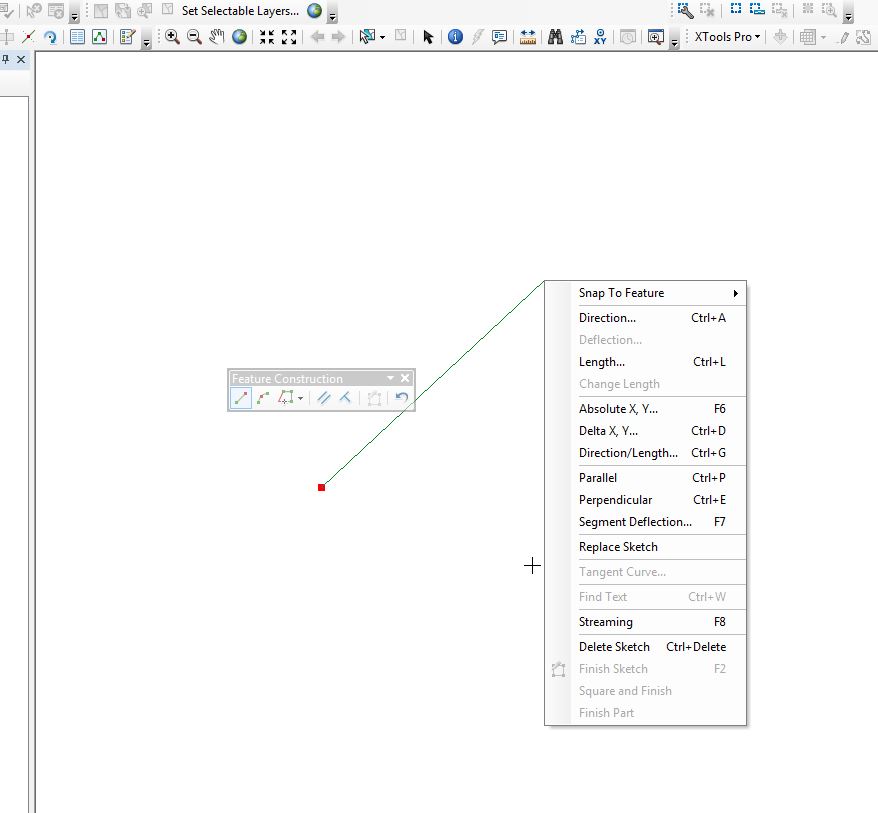
One can also create a line direction by starting an editing session, clicking to create your first point, then right-clicking which will bring up a menu (see below). You can choose "Direction" from the menu and it will then draw the line in that direction.
NOTE: By default, angles are entered in degrees using the polar system, which is measured counterclockwise from the positive x-axis. You can specify a different direction measuring system or unit on the Editing Options dialog box > Units tab.
Source: ArcGIS Help (10.2, 10.2.1, and 10.2.2)
Chris Donohue, GISP
- Mark as New
- Bookmark
- Subscribe
- Mute
- Subscribe to RSS Feed
- Permalink
- Report Inappropriate Content
If you want to digitize a line in a specific direction, this may be of help:
ArcGIS Help (10.2, 10.2.1, and 10.2.2)
Chris Donohue, GISP
- Mark as New
- Bookmark
- Subscribe
- Mute
- Subscribe to RSS Feed
- Permalink
- Report Inappropriate Content
Another flavor:
One can also create a line direction by starting an editing session, clicking to create your first point, then right-clicking which will bring up a menu (see below). You can choose "Direction" from the menu and it will then draw the line in that direction.
NOTE: By default, angles are entered in degrees using the polar system, which is measured counterclockwise from the positive x-axis. You can specify a different direction measuring system or unit on the Editing Options dialog box > Units tab.
Source: ArcGIS Help (10.2, 10.2.1, and 10.2.2)
Chris Donohue, GISP
- Mark as New
- Bookmark
- Subscribe
- Mute
- Subscribe to RSS Feed
- Permalink
- Report Inappropriate Content
Thank you Chris. That is exactly what I was looking for.