- Home
- :
- All Communities
- :
- Products
- :
- Spatial Statistics
- :
- Spatial Statistics Questions
- :
- Is there a tool already created that will calculat...
- Subscribe to RSS Feed
- Mark Topic as New
- Mark Topic as Read
- Float this Topic for Current User
- Bookmark
- Subscribe
- Mute
- Printer Friendly Page
Is there a tool already created that will calculate the total area for each pixel value in a raster that falls within each zone in an overlayed poygon?
- Mark as New
- Bookmark
- Subscribe
- Mute
- Subscribe to RSS Feed
- Permalink
- Report Inappropriate Content
I am about to create a model to do this, but before I go and do that I want to be sure whether this exists already.
I need to find out the area of each pixel value from a raster within a zone from a polygon overlayed. The closest I have found to this so far is the "zonal statistics" tool in the ESRI Spatial Analyst Toolbox. Ultimately, I would like to join the table to the original polygon zone layer to add these values as attributes of the zone.
Thanks in advance,
Matt Syvertson
Solved! Go to Solution.
Accepted Solutions
- Mark as New
- Bookmark
- Subscribe
- Mute
- Subscribe to RSS Feed
- Permalink
- Report Inappropriate Content
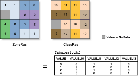
I think you're looking for Tabulate Area, using a county feature layer as the zone input.
- Mark as New
- Bookmark
- Subscribe
- Mute
- Subscribe to RSS Feed
- Permalink
- Report Inappropriate Content
Zonal Statistics as Table—Help | ArcGIS for Desktop
cell area is cell width*cell height. Area is cell area * cell count
- Mark as New
- Bookmark
- Subscribe
- Mute
- Subscribe to RSS Feed
- Permalink
- Report Inappropriate Content
I might not have been clear about what I am trying to do, so I will use an example. Lets say I have a polygon layer which has all counties in the state, and I have a raster layer in which each pixel has a value range of 1-5. I would like to overlay the two and receive a table with the columns county,1,2,3,4, and 5. So for each line, I would like the county name, the area of value one in that county, the area of value 2 in the county, etc...
- Mark as New
- Bookmark
- Subscribe
- Mute
- Subscribe to RSS Feed
- Permalink
- Report Inappropriate Content
I think you're looking for Tabulate Area, using a county feature layer as the zone input.
- Mark as New
- Bookmark
- Subscribe
- Mute
- Subscribe to RSS Feed
- Permalink
- Report Inappropriate Content
Thanks Darren. That worked perfectly.