- Home
- :
- All Communities
- :
- Products
- :
- Spatial Data Science
- :
- Spatial Data Science Questions
- :
- Re: In the "Finding Hot Spots" Geoanalytics deskto...
- Subscribe to RSS Feed
- Mark Topic as New
- Mark Topic as Read
- Float this Topic for Current User
- Bookmark
- Subscribe
- Mute
- Printer Friendly Page
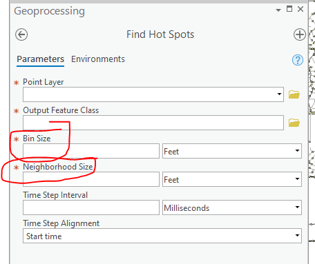
In the "Finding Hot Spots" Geoanalytics desktop tool in ArcPro what is the difference between the the parameters between "Bin size" and "Neighborhood size"?
- Mark as New
- Bookmark
- Subscribe
- Mute
- Subscribe to RSS Feed
- Permalink
- Report Inappropriate Content
- Mark as New
- Bookmark
- Subscribe
- Mute
- Subscribe to RSS Feed
- Permalink
- Report Inappropriate Content
Find Hot Spots—GeoAnalytics Tools | Documentation
and the code example gives a tiny description
Description: Find Hots Spots of 311 calls for bins of 500 meters looking at neighbors withing 1 kilometers. Complete the analysis for each month.
Which I suspect doesn't help if the parameter description for the tool doesn't help.
Have you looked at the related help topics for hot spot analysis that are in the spatial analyst extension? There are other tools that are similar, but I will spare you those links pending further commentary as to what you have actually looked and what you are trying to accomplish
- Mark as New
- Bookmark
- Subscribe
- Mute
- Subscribe to RSS Feed
- Permalink
- Report Inappropriate Content
Hey -
The bin size is the area you are aggregating your raw points into. From the documentation:
The distance interval that represents the bin size and units into which the point_layer will be aggregated. The distance interval must be a linear unit.
So from the image in the topic - the image on the right would have 36 bins: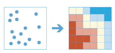
The neighborhood size is used to compare a bin to it's neighboring bins:
The spatial extent of the analysis neighborhood. This value determines which features are analyzed together to assess local clustering.
The neighborhood size must be greater than the bin size. This is similar to the distance band parameter in the Hot Spot Analysis (Getis-Ord Gi*) tool works.
So with a bit of an adaptation of the Hot Spot Analysis (Getis-Ord Gi*) doc - this should help explain it:
Each feature (bin!) will be analyzed within the context of neighboring features (bins). Neighboring features inside the specified neighborhood size will receive a weight of one and exert influence on computations for the target feature. Neighboring features outside the critical distance will receive a weight of zero and have no influence on a target feature's computations.
Let me know if that help clarify it, and I'll modify the GeoAnalytics tool doc to be more clear for the next release.
Thanks,
Sarah Ambrose
GeoAnalytics Team
- Mark as New
- Bookmark
- Subscribe
- Mute
- Subscribe to RSS Feed
- Permalink
- Report Inappropriate Content
hence my commentary
...I will spare you those links pending further commentary...
adding a visual of the bins size and the distance band would certainly help, especially given the most users of "hot spot" anything have little to no GIS of statistical background (as I am sure that you are aware) 
- Mark as New
- Bookmark
- Subscribe
- Mute
- Subscribe to RSS Feed
- Permalink
- Report Inappropriate Content
Hey Dan thanks for your response. I have a little better idea of the difference now between Bin size and Neighborhood size. You are correct, in that I am like many users who do not have a statistical background in statistics. However, after a few iterations of various bin and neighborhood sizes, the data points, (which are car accidents in the City of Overland Park, KS) seem to align more accurately with the bins. 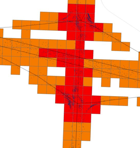
- Mark as New
- Bookmark
- Subscribe
- Mute
- Subscribe to RSS Feed
- Permalink
- Report Inappropriate Content
Hey Sarah thanks for your quick response! I did find it helpful the way you explained it. I might also have a few more questions for you, in the near future, if that is all right concerning the Hot Spot Analysis/Optimized Hot Spot analysis tools in the Spatial Statistics tool box.