- Home
- :
- All Communities
- :
- Developers
- :
- Python
- :
- Python Questions
- :
- Re: Elevation profile geoprocessing service - erro...
- Subscribe to RSS Feed
- Mark Topic as New
- Mark Topic as Read
- Float this Topic for Current User
- Bookmark
- Subscribe
- Mute
- Printer Friendly Page
Elevation profile geoprocessing service - error 000840
- Mark as New
- Bookmark
- Subscribe
- Mute
- Subscribe to RSS Feed
- Permalink
- Report Inappropriate Content
Hi,
I am trying to create an Elevation Profile service using the Python code found on the link:
http://www.arcgis.com/home/item.html?id=0d47b17d3b884b9d977a6f76fc6bfcaa
And I followed all the instructions. I am able to publish the geoprocessing service, but when I run the gp service inside ArcGIS I get an error saying:
Error executing tool.: Failed to execute. Parameters are not valid. ERROR 000840: The value is not a TIN Layer. ERROR 000840: The value is not a Raster Layer. ERROR 000840: The value is not a Terrain Layer. ERROR 000840: The value is not a LAS Dataset Layer. Failed to execute (InterpolateShape). Failed to execute. Parameters are not valid. ERROR 000840: The value is not a TIN Layer. ERROR 000840: The value is not a Raster Layer. ERROR 000840: The value is not a Terrain Layer. ERROR 000840: The value is not a LAS Dataset Layer. Failed to execute (InterpolateShape). Failed to execute (Profile). Failed to execute (Profile).
The problem seems to be in the Interpolate Shape analysis in line 307 but I am not sure what is wrong with it. Do you guys have any ideas? Here is the code below. Thank you so much!
""" Tool name: Profile
Source name: Profile Tool.pyt
Description: Return an elevation profile for an input polyline.
Author: Environmental Systems Research Institute Inc.
Last updated: Aug. 05, 2014
"""
import os
import time
import arcpy
class Toolbox(object):
def __init__(self):
"""Define the toolbox (the name of the toolbox is the name of the
.pyt file)."""
self.label = "Profile Tool"
self.alias = ""
# List of tool classes associated with this toolbox
self.tools = [Profile]
class Profile(object):
def __init__(self):
"""Define the tool (tool name is the name of the class)."""
self.label = "Profile"
self.description = "Return an elevation profile for an input polyline."
self.canRunInBackground = False
# custom properties
self.debug = True
self.outputToTable = False # set to True to direct the output to a table.
self.idFieldName = "ID"
self.glen_field1 = "proflen0"
self.glen_field2 = "proflen1"
self.metadataFieldName = "DEMResolution"
self.geodesicLenFieldName = "ProfileLength"
self.listLinearUnits = ["Meters", "Kilometers", "Feet", "Yards", "Miles"]
#---------------------------------------------------
# Maximum number of vertices
#---------------------------------------------------
self.maxNumVertices = 2000
#---------------------------------------------------
# DEM boundary layer
#----------------------------------------------------
boundaryLayer1 = "demboundary"
if False:
arcpy.Describe(boundaryLayer1)
self.demBoundary = boundaryLayer1
#----------------------------------------------------
# Profile schema feature class
#----------------------------------------------------
profileSchm1 = r"D:\ArcGISData\ElevationProfile\ProfileData\dembnd.gdb\profileschema"
self.profileSchema = profileSchm1
#----------------------------------------------------
# DEM resolution dictionary
#---------------------------------------------------
self.dictDEMResolutions = {"90m":"90", "30m":"30", "10m":"10"}
self.defaultDEMResolution = '90'
#---------------------------------------------------
# DEM data layers
#---------------------------------------------------
# Define layer variables
#---------------------------------------------------
demLayer1 = "dem90m"
demLayer2 = "dem30m"
demLayer3 = "dem10m"
#---------------------------------------------------
# Wrap each variable in an arcpy.Describe statement
#---------------------------------------------------
if False:
arcpy.Describe(demLayer1)
arcpy.Describe(demLayer2)
arcpy.Describe(demLayer3)
#---------------------------------------------------
# Update the DEM layers dictionary
#---------------------------------------------------
self.dictDEMs = {"90":demLayer1,
"30":demLayer2,
"10":demLayer3}
#----------------------------------------------------
# DEM coordinate system
demSR = arcpy.Describe(self.dictDEMs.values()[0]).spatialReference
self.demCoordinateSystem = demSR
# DEM linear unit
lun = demSR.linearUnitName
if lun == "" or lun == None:
lun = demSR.angularUnitName
if 'degree' in lun.lower():
lun = 'decimaldegrees'
if 'foot' in lun.lower() or 'feet' in lun.lower():
lun = 'feet'
self.demLinearUnit = lun
# for adjusting length, change the zf here. eg, if the DEM linear unit is feet, then zf = 0.3048.
# for meter, zf = 1.0; for decimal degrees, use zf = 1.0
self.zFactor = self.getUnitConversionFactor(self.demLinearUnit)
self.errorMessages = ["No input polyline features specified. The input needs to have at list one line feature.",
"Input resolution is not supported. Select a different DEM source.",
"The input profile line you requested falls outside of the data currently available in this service.",
"Input parameter {0} is not valid.",
"The input polyline contains too many vertices. Reduce the number of vertices.",
"The specified sample distance results in more vertices than allowed. Increase sampling distance.",
"Input feature contains too many vertices or the sample distance is too small. Specify a line with less than 1024 vertices, or increase the sampling distance.",
"Input sample distance cannot be 0 or negative.",
"Input feature id field does not exist. Change to another field or leave it as default.",
"The number of input profile lines exceeds limit. Reduce the number of input profile lines to not more than 10."]
def getLayerName(self, res):
if not res in self.dictDEMs.keys():
arcpy.AddError(self.errorMessages[1])
raise
return
return self.dictDEMs[res]
def getUnitConversionFactor(self, u1): # get conversion factor
uFactor = 1
inUnit = u1.strip().lower()
if inUnit in ["meters", "meter"]:
uFactor = 1
if inUnit in ["centimeters", "centimeter"]:
uFactor = 0.01
if inUnit in ["decimaldegrees", "decimaldegree"]:
uFactor = 1
if inUnit in ["decimeters", "decimeter"]:
uFactor = 0.1
if inUnit in ["feet", "foot"]:
uFactor = 0.3048
if inUnit in ["foot_us", "feet_us"]:
uFactor = 0.3048006096012192
if inUnit in ["inches","inch"]:
uFactor = 0.0254
if inUnit in ["kilometers", "kilometer"]:
uFactor = 1000
if inUnit in ["miles","mile"]:
uFactor = 1609.344
if inUnit in ["millimeters", "millimeter"]:
uFactor = 0.001
if inUnit in ["nauticalmiles", "nauticalmile"]:
uFactor = 1852
if inUnit in ["points", "point"]:
uFactor = 0.000352777778
if inUnit in ["unknown", ""]:
uFactor = 1
if inUnit in ["yards", "yard"]:
uFactor = 0.91440
return uFactor
def lineFootprintTest(self, in_line_features):
# Footprint polygon
footPrt = self.demBoundary
resList = []
footPrtLayer = 'aFootPrtLyr'
arcpy.MakeFeatureLayer_management(footPrt,footPrtLayer)
arcpy.SelectLayerByLocation_management(footPrtLayer, "COMPLETELY_CONTAINS",
in_line_features)
self.traceExecutionTime("")
with arcpy.da.SearchCursor(footPrtLayer, "res") as cursor:
for row in cursor:
resList.append(row[0])
return resList
def CountVerticesAndLength(self, in_polylines1):
countL = 0
countV = 0
totalLen = 0
individualLen = []
list_oid = []
list_vert = []
list_geodesiclen = []
with arcpy.da.SearchCursor(in_polylines1, ("Shape@", "Shape@Length", "OID@", self.glen_field2)) as cur:
for row in cur:
countL += 1
countV += row[0].getPart(0).count
totalLen += row[1]
individualLen.append(row[1])
list_oid.append(row[2])
list_vert.append(row[0].getPart(0).count)
list_geodesiclen.append(row[3])
return (countL, countV, totalLen, individualLen, list_oid, list_vert, list_geodesiclen)
def CountVerticesNoProjection(self, in_polylines1):
countV = 0
with arcpy.da.SearchCursor(in_polylines1, ("Shape@")) as cur:
for row in cur:
countV += row[0].getPart(0).count
return countV
def getResolutionByLength(self, in_len):
dem_res = []
if in_len < 5000:
dem_res = [10, 30, 90]
if in_len >= 5000 and in_len < 15000:
dem_res = [30, 90]
if in_len >= 15000:
dem_res = [90]
return dem_res
def getResolutionByLengthFootprint(self, in_polylines, total_len):
len_candidates = self.getResolutionByLength(total_len)
foot_candidates = self.lineFootprintTest(in_polylines)
self.traceExecutionTime("")
foot_candidates_int = [int(x) for x in foot_candidates]
res_list = [i for i in len_candidates if i in foot_candidates_int]
res_list.sort()
if len(res_list) == 0:
arcpy.AddError(self.errorMessages[2])
raise
return res_list
def getResolutionByFootprint(self, in_polylines):
foot_candidates = self.lineFootprintTest(in_polylines)
self.traceExecutionTime("")
foot_candidates_int = [int(x) for x in foot_candidates]
foot_candidates_int.sort()
if len(foot_candidates_int) == 0:
arcpy.AddError(self.errorMessages[2])
raise
return foot_candidates_int
def getDefaultNumberVertices(self, in_number_vertices):
out_num = None
if in_number_vertices <= 50:
out_num = 50
if in_number_vertices > 50 and in_number_vertices <= 200:
out_num = 200
if in_number_vertices > 200:
out_num = in_number_vertices
return out_num
def densifyLine(self, in_line_features, distanceLU):
if distanceLU != "": # only do it when not empty
arcpy.Densify_edit(in_line_features, "DISTANCE", distanceLU)
self.traceExecutionTime("")
def weedLine(self, in_line_features, in_toler):
if in_toler <> 0: # only do it when not 0
arcpy.Generalize_edit(in_line_features, in_toler)
self.traceExecutionTime("")
def traceExecutionTime(self, msg):
if self.debug:
if msg <> None:
arcpy.AddMessage(msg)
arcpy.AddMessage(arcpy.GetMessages())
def printCoordinateSystem(self, in_dataset):
des = arcpy.Describe(in_dataset)
arcpy.AddMessage(des.SpatialReference.name)
def validateNumerical(self, inVal, paramStr):
if inVal == None: # None is OK
return
elif inVal <= 0:
arcpy.AddError(self.errorMessages[7].format(paramStr))
raise
def validateDistanceUnits(self, inStr, paramStr):
tempUnitsList = [s.lower() for s in self.listLinearUnits]
tempUnitsList.extend(["#", ""])
if inStr == None: # None is OK
return
elif not (inStr.lower() in tempUnitsList):
arcpy.AddError(self.errorMessages[3].format(paramStr))
raise
def validateInputDEMSource(self, inDEM):
tempDEMList = [s.upper() for s in self.dictDEMResolutions.keys()]
tempDEMList.extend(["", "FINEST", "#"])
if inDEM == None: # None is OK
return
elif not (inDEM.strip().upper() in tempDEMList):
arcpy.AddError(self.errorMessages[1].format(inDEM))
raise
def validateFeatureIDField(self, inName, inFeature):
fldList = arcpy.ListFields(inFeature)
fldListLower = [f.name.lower() for f in fldList]
if inName == None: # None is OK
return
elif not (inName.lower() in fldListLower):
arcpy.AddError(self.errorMessages[8])
raise
def formatInputDEMSource(self, inSource):
tempDEMList = self.dictDEMResolutions.keys()
tempDEMList.extend(["", "FINEST"])
retVal = inSource
for d in tempDEMList:
if inSource.upper() == d.upper():
retVal = d
break
return retVal
def createProfile(self, in_line_features, inputIsInOcean, line_id_field, idFieldIsTemp, inputSR,
dem_resolution, line_count, list_geodesiclen, out_profile):
try:
line_features_inputCS = os.path.join(r"in_memory", r"linetmpafterprj03")
route_temp = os.path.join(r"in_memory", "outroutetmp")
interp_line_temp = r"in_memory\interpouttmp"
out_vertices_temp = r"in_memory\verticestmp"
arcpy.env.workspace = "in_memory"
# get Z values from DEM
arcpy.InterpolateShape_3d(in_surface=self.getLayerName(dem_resolution),
in_feature_class=in_line_features,
out_feature_class=interp_line_temp,
vertices_only="VERTICES_ONLY")
self.traceExecutionTime("")
# Calculate M values using Create Routes tool
# By default, M is in meters. To change the M unit,
# change the unit in which glen_field2 is calculated (in the execute method)
arcpy.CreateRoutes_lr(in_line_features=interp_line_temp, route_id_field=line_id_field,
out_feature_class=route_temp, measure_source="TWO_FIELDS",
from_measure_field=self.glen_field1, to_measure_field=self.glen_field2)
self.traceExecutionTime("")
if self.outputToTable: # out to table
# project the line
arcpy.env.outputCoordinateSystem = inputSR # convert to input projection
arcpy.CopyFeatures_management(route_temp, line_features_inputCS) # project
self.traceExecutionTime("")
arcpy.env.outputCoordinateSystem = ""
# extract X, Y, Z, M
arcpy.CreateTable_management("in_memory", os.path.basename(out_profile), os.path.join(os.path.dirname(__file__), "profile_schema.dbf"))
self.traceExecutionTime("")
with arcpy.da.InsertCursor(out_profile, ("ID", "POINT_X", "POINT_Y", "POINT_M", "POINT_Z")) as icur:
with arcpy.da.SearchCursor(line_features_inputCS, ("Shape@", line_id_field)) as scur:
for row in scur:
geo = row[0]
id_val = row[1]
for l1 in geo.getPart():
for pnt in l1:
x = pnt.X
y = pnt.Y
m = pnt.M
z = pnt.Z
icur.insertRow((id_val, x, y, m, z))
else: # out to line
# project the line
arcpy.env.outputCoordinateSystem = inputSR # convert to input projection
arcpy.CopyFeatures_management(route_temp, out_profile) # project
self.traceExecutionTime("")
arcpy.env.outputCoordinateSystem = ""
# Add metadata info
if inputIsInOcean:
dem_source = ['1000m']
else:
dem_source = [k for k, v in self.dictDEMResolutions.iteritems() if v == str(dem_resolution)]
arcpy.AddField_management(out_profile, self.metadataFieldName, "TEXT", field_length=50, field_alias="DEM Resolution")
arcpy.CalculateField_management(out_profile, self.metadataFieldName, "'" + dem_source[0] + "'", "PYTHON")
# Add geodesic length for profile
arcpy.AddField_management(out_profile, self.geodesicLenFieldName, "DOUBLE", field_alias="Length Meters")
i = 0
with arcpy.da.UpdateCursor(out_profile, self.geodesicLenFieldName) as ucur:
for row in ucur:
row[0] = list_geodesiclen
i += 1
ucur.updateRow(row)
# remove tempid field
if idFieldIsTemp:
arcpy.DeleteField_management(out_profile, line_id_field)
except:
msgs = arcpy.GetMessages(2)
arcpy.AddError(msgs)
raise
def getParameterInfo(self):
"""Define parameter definitions"""
param0 = arcpy.Parameter(name="InputLineFeatures",
displayName="Input Line Features",
direction="Input",
parameterType="Required",
datatype="GPFeatureRecordSetLayer")
# Feautre set schema
param0.value = self.profileSchema
param1 = arcpy.Parameter(name="ProfileIDField",
displayName="Profile ID Field",
direction="Input",
parameterType="Optional",
datatype="Field")
param1.filter.list = ['OID', 'Short', 'Long']
param2 = arcpy.Parameter(name="DEMResolution",
displayName="DEM Resolution",
direction="Input",
parameterType="Optional",
datatype="GPString")
param2.filter.type = "ValueList"
list_dem = [" ", "FINEST"]
dem_keys = self.dictDEMResolutions.keys()
dem_keys.sort()
list_dem.extend(dem_keys)
param2.filter.list = list_dem
param3 = arcpy.Parameter(name="MaximumSampleDistance",
displayName="Maximum Sample Distance",
direction="Input",
parameterType="Optional",
datatype="GPDouble")
param4 = arcpy.Parameter(name="MaximumSampleDistanceUnits",
displayName="Maximum Sample Distance Units",
direction="Input",
parameterType="Optional",
datatype="GPString")
param4.filter.type = "ValueList"
param4.filter.list = self.listLinearUnits
param4.value = "Meters"
param5 = arcpy.Parameter(name="OutputProfile",
displayName="Output Profile",
direction="Output",
parameterType="Derived",
datatype="DEFeatureClass")
params = [param0, param1, param2, param3, param4, param5]
return params
def isLicensed(self):
"""Set whether tool is licensed to execute."""
return True
def updateParameters(self, parameters):
"""Modify the values and properties of parameters before internal
validation is performed. This method is called whenever a parameter
has been changed."""
return
def updateMessages(self, parameters):
"""Modify the messages created by internal validation for each tool
parameter. This method is called after internal validation."""
return
def execute(self, parameters, messages):
"""The source code of the tool."""
try:
startTime = time.time()
self.debug = False
in_polylines = parameters[0].value
profile_id_field = parameters[1].valueAsText
dem_resolution_p = parameters[2].valueAsText
sample_distance_p = parameters[3].value
sample_distance_units = parameters[4].valueAsText
out_profile = os.path.join("in_memory", "profile1")
arcpy.env.overwriteOutput = True
maxInputLines = 100 # sync is 100, async is 1000
if ("elevation_gpserver" in arcpy.env.scratchWorkspace):
maxInputLines = 1000
# Get input SR
d0 = arcpy.Describe(in_polylines)
inputSR = d0.spatialReference
oidfld1 = d0.OIDFieldName
# project first
polylines_after_prj = os.path.join("in_memory", "inputlinetmp02")
# project to raster coordinate system
arcpy.env.outputCoordinateSystem = self.demCoordinateSystem
arcpy.CopyFeatures_management(in_polylines, polylines_after_prj) # project
arcpy.env.outputCoordinateSystem = ""
self.traceExecutionTime("")
# Add and calcualte geodesic length fields - from field and to field for
# Create Routes tool to calculate the M values
arcpy.AddField_management(polylines_after_prj, self.glen_field1, "DOUBLE")
self.traceExecutionTime("")
arcpy.CalculateField_management(polylines_after_prj, self.glen_field1,
"0", "PYTHON_9.3")
self.traceExecutionTime("")
# The unit in which glen_field2 is calculated determines the M unit.
# To change it other units, replace meters below with desired units
arcpy.AddField_management(polylines_after_prj, self.glen_field2, "DOUBLE")
self.traceExecutionTime("")
arcpy.CalculateField_management(polylines_after_prj, self.glen_field2,
"!shape.geodesiclength@meters!", "PYTHON_9.3")
self.traceExecutionTime("")
# validate profile id field
time_a = time.time()
self.validateFeatureIDField(profile_id_field, in_polylines)
time_b = time.time()
if self.debug:
arcpy.AddMessage("ValidateFeatureIDField execution time: " + str(time_b - time_a))
# make temp id field
idFieldIsTemp = False
temp_id_field = "tmpprflid_"
if profile_id_field == None:
idFieldIsTemp = True # needed for field removal later
fieldSp = 0
fieldIsObjID = 1
profile_id_field = temp_id_field
elif profile_id_field.lower() in ["oid", "fid", "objectid"]:
idFieldIsTemp = True # needed for field removal later
fieldSp = 1
fieldIsObjID = 0
profile_id_field = temp_id_field
if profile_id_field == temp_id_field: # default
arcpy.AddField_management(polylines_after_prj, profile_id_field, "LONG")
self.traceExecutionTime("")
arcpy.CalculateField_management(polylines_after_prj, profile_id_field, "!" + oidfld1 + "!", "PYTHON_9.3")
self.traceExecutionTime("")
# var for metering
fieldSp = 1
fieldIsObjID = 1
samplingDistSp = 0
# now find the line length and number of vertices
time_a = time.time()
lineFact = self.CountVerticesAndLength(polylines_after_prj)
time_b = time.time()
if self.debug:
arcpy.AddMessage("CountVerticesAndLength execution time: " + str(time_b - time_a))
line_counts = lineFact[0]
total_num_vert = lineFact[1]
total_len = lineFact[2]
indiv_len = lineFact[3]
list_oid = lineFact[4]
list_vert = lineFact[5]
list_glen = lineFact[6]
if line_counts < 1:
arcpy.AddError(self.errorMessages[0])
raise
elif line_counts > maxInputLines:
arcpy.AddError(self.errorMessages[9])
raise
self.validateNumerical(sample_distance_p, "Maximum Sample Distance")
self.validateDistanceUnits(sample_distance_units, "Maximum Sample Distance Units")
self.validateInputDEMSource(dem_resolution_p)
# trim dem_resolution_p
if dem_resolution_p is not None and str(dem_resolution_p).upper() <> "FINEST":
if dem_resolution_p.strip() == "":
dem_resolution_p = None
if dem_resolution_p is not None:
dem_resolution_p = self.dictDEMResolutions[self.formatInputDEMSource(dem_resolution_p)]
# determine whether input line is in ocean
inputIsInOcean = False
# determine resolution
if str(dem_resolution_p).upper() <> "FINEST":
if dem_resolution_p is None: # case 1 blank (default)
dem_resolution = self.defaultDEMResolution
res_list = self.getResolutionByFootprint(polylines_after_prj)
if not int(dem_resolution) in res_list:
arcpy.AddError(self.errorMessages[2])
raise
return
else: # case 2 specified
dem_resolution = dem_resolution_p
res_list = self.getResolutionByFootprint(polylines_after_prj)
if not int(dem_resolution) in res_list:
arcpy.AddError(self.errorMessages[2])
raise
return
else: # case 3 - FINEST:
res_list = self.getResolutionByFootprint(polylines_after_prj)
dem_resolution = str(int(res_list[0]))
if sample_distance_units == None:
sample_distance_units = "meters"
outfeaturelayer1 = "tempfeaturelayer"
arcpy.MakeFeatureLayer_management(polylines_after_prj, outfeaturelayer1)
self.traceExecutionTime("")
for oid_val in list_oid:
query_exp = oidfld1 + "=" + str(oid_val)
arcpy.SelectLayerByAttribute_management(outfeaturelayer1, "NEW_SELECTION", query_exp)
self.traceExecutionTime("")
in_len = indiv_len[list_oid.index(oid_val)] # individual line length
in_glen = list_glen[list_oid.index(oid_val)] # individual glength
ratio1 = in_len / (in_glen / self.zFactor) # ratio to convert to Mercator
in_num_vert = list_vert[list_oid.index(oid_val)] # individual line vertex number
if sample_distance_p == None: # default
samplingDistSp = 0 # metering
out_num_vert = in_num_vert
needDensify = False
needWeed = False
if in_num_vert < 50:
out_num_vert = 50
needDensify = True
elif in_num_vert >= 50 and in_num_vert < 200:
out_num_vert = 200
needDensify = True
elif in_num_vert >= 200 and in_num_vert <= self.maxNumVertices:
out_num_vert = in_num_vert
needDensify = False
elif in_num_vert > self.maxNumVertices:
out_num_vert = self.maxNumVertices
needDensify = False
needWeed = True
sample_distance_m = in_len / (out_num_vert - 1) # default sample distance
if needDensify:
# change the unit here to DEM linear unit, eg, feet, meters, decimaldegrees
self.densifyLine(outfeaturelayer1, str(sample_distance_m) + " " + self.demLinearUnit)
if needWeed:
self.weedLine(outfeaturelayer1, str(int(dem_resolution) / 4.0) + " " + self.demLinearUnit)
else: # specified
samplingDistSp = 1 # metering
newSamplingDist = ratio1 * sample_distance_p # convert to GCS distance
sample_distance_m = newSamplingDist * self.getUnitConversionFactor(sample_distance_units) / self.zFactor # convert to Feet
nVert = int((in_len / sample_distance_m) + 1)
if nVert > self.maxNumVertices:
arcpy.AddError(self.errorMessages[5])
raise
return
else:
self.densifyLine(outfeaturelayer1, str(sample_distance_m) + " " + self.demLinearUnit)
# final count of no. vertices
nVert1 = self.CountVerticesNoProjection(outfeaturelayer1)
if nVert1 > self.maxNumVertices * 2:
arcpy.AddError(self.errorMessages[6])
raise
return
# Execute the tool, line is already densified
arcpy.AddMessage("DEM Resolution: " + dem_resolution + ", Sampling Distance: "
+ str(sample_distance_m))
self.createProfile(polylines_after_prj, inputIsInOcean, profile_id_field, idFieldIsTemp, inputSR,
dem_resolution, line_counts, list_glen, out_profile)
arcpy.SetParameterAsText(5, out_profile)
except:
msgs = arcpy.GetMessages(2)
arcpy.AddError(msgs)
- Mark as New
- Bookmark
- Subscribe
- Mute
- Subscribe to RSS Feed
- Permalink
- Report Inappropriate Content
Hello inoara, I am wondering if you've resolved the errors and are able to run the profile service in your organization's arcgis server? I got the an error "Input resolution is not supported. Select a different DEM source" while trying to publish the profile service to our arcgis server and wonder if you could provide any suggestion in resolving this error?
Executing: Profile C:\Users\zhangj\Documents\ProfileData\dembnd.gdb\profileschema # 10m # Meters
Start Time: Mon Oct 20 09:45:22 2014
Running script Profile...
DEM Resolution: 10, Sampling Distance: 170.262832632
Input resolution is not supported. Select a different DEM source.
Completed script Profile...
Failed to execute (Profile).
Failed at Mon Oct 20 09:45:26 2014 (Elapsed Time: 3.65 seconds)
Thank you and regards,
Jin
- Mark as New
- Bookmark
- Subscribe
- Mute
- Subscribe to RSS Feed
- Permalink
- Report Inappropriate Content
I also got this error "The input profile line you requested falls outside of the data currently available in this service." Could someone please tell me what could be the possible cause?
Thank you and regards,
Jin
- Mark as New
- Bookmark
- Subscribe
- Mute
- Subscribe to RSS Feed
- Permalink
- Report Inappropriate Content
I am not sure what we did to fix it . I think because we only needed to work with 10 meters, we did not need the other DEMs so we changed from
- demLayer1 = "dem90m"
- demLayer2 = "dem30m"
- demLayer3 = "dem10m"
to
demLayer1 = "dem10m"
demLayer2 = "dem10m"
demLayer3 = "dem10m"
Your last error seems to indicate you are selecting an area outside the area that ESRI created the DEM for. You need to test in the same area of the extent of the DEM ESRI made available.
- Mark as New
- Bookmark
- Subscribe
- Mute
- Subscribe to RSS Feed
- Permalink
- Report Inappropriate Content
Thank you ionara, we want to work with 1 meter and I did change
- demLayer1 = "dem90m"
- demLayer2 = "dem30m"
- demLayer3 = "dem10m"
to
demLayer1 = "dem1m"
But still get the "The input profile line you requested falls outside of the data currently available in this service." I am wondering if 1 meter is not supported? I also noticed that our
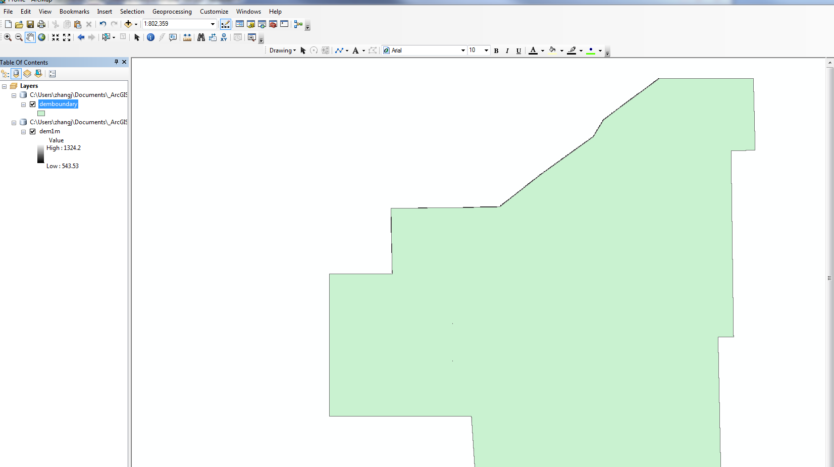
While comparing our dem1m raster data to ESRI’s sample dem data, I noticed the attribute of the image under DEM data all have 0 as their Low value, however ours is 543.53. I am wondering if we have to update our dem raster data to change the low value to 0? Here is what our profile.mxd looks like:
Regards,
Jin
- Mark as New
- Bookmark
- Subscribe
- Mute
- Subscribe to RSS Feed
- Permalink
- Report Inappropriate Content
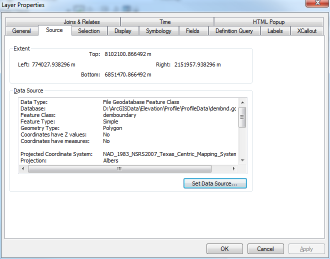
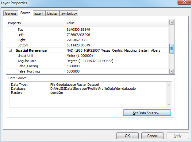
When do you get this error? After running the gp in a web service or during service publishing or when you run the gp in ArcMap? It is still complaining about the input not being in the same extent. I think the line file that you use to digitize might not be in the same projection. Make sure the spatial references are all the same. I dont think it has to do with low or high values. Notice on my images, that all 3 files, the profileschema, the demboundary and the dem are in the same coordinate systems.
Here is the code that works for us. It is difficult for me to help since I cant see your code or the environment in your machine but I believe it is still a problem with the coordinate system. Good luck

""" Tool name: Profile
Source name: Profile Tool.pyt
Description: Return an elevation profile for an input polyline.
Author: Environmental Systems Research Institute Inc.
Last updated: Aug. 05, 2014
"""
import os
import time
import arcpy
from arcpy.sa import *
class Toolbox(object):
def __init__(self):
"""Define the toolbox (the name of the toolbox is the name of the
.pyt file)."""
self.label = "Profile Tool"
self.alias = ""
# List of tool classes associated with this toolbox
self.tools = [Profile]
class Profile(object):
def __init__(self):
"""Define the tool (tool name is the name of the class)."""
self.label = "Profile"
self.description = "Return an elevation profile for an input polyline."
self.canRunInBackground = False
# custom properties
self.debug = True
self.outputToTable = False # set to True to direct the output to a table.
self.idFieldName = "ID"
self.glen_field1 = "proflen0"
self.glen_field2 = "proflen1"
self.metadataFieldName = "DEMResolution"
self.geodesicLenFieldName = "ProfileLength"
self.listLinearUnits = ["Meters", "Kilometers", "Feet", "Yards", "Miles"]
#---------------------------------------------------
# Maximum number of vertices
#---------------------------------------------------
self.maxNumVertices = 2000
#---------------------------------------------------
# DEM boundary layer
#----------------------------------------------------
#arcpy.MakeFeatureLayer_management(r"D:\arcgisdata\Elevation\Profile\ProfileData\dembnd.gdb\demboundary", "demboundary")
boundaryLayer1 = "demboundary"
if False:
arcpy.Describe(boundaryLayer1)
self.demBoundary = boundaryLayer1
#----------------------------------------------------
# Profile schema feature class
#----------------------------------------------------
profileSchm1 = r"D:\ArcGISData\Elevation\Profile\ProfileData\dembnd.gdb\profileschema"
self.profileSchema = profileSchm1
#----------------------------------------------------
# DEM resolution dictionary
#---------------------------------------------------
self.dictDEMResolutions = {"90m":"90", "30m":"30", "10m":"10"}
self.defaultDEMResolution = '90'
#---------------------------------------------------
# DEM data layers
#---------------------------------------------------
# Define layer variables
#---------------------------------------------------
demLayer1 = "dem10m"
demLayer2 = "dem10m"
demLayer3 = "dem10m"
#---------------------------------------------------
# Wrap each variable in an arcpy.Describe statement
#---------------------------------------------------
if False:
arcpy.Describe(demLayer1)
arcpy.Describe(demLayer2)
arcpy.Describe(demLayer3)
#---------------------------------------------------
# Update the DEM layers dictionary
#---------------------------------------------------
self.dictDEMs = {"90":demLayer1,
"30":demLayer2,
"10":demLayer3}
#----------------------------------------------------
# DEM coordinate system
demSR = arcpy.Describe(self.dictDEMs.values()[0]).spatialReference
self.demCoordinateSystem = demSR
# DEM linear unit
lun = demSR.linearUnitName
if lun == "" or lun == None:
lun = demSR.angularUnitName
if 'degree' in lun.lower():
lun = 'decimaldegrees'
if 'foot' in lun.lower() or 'feet' in lun.lower():
lun = 'feet'
self.demLinearUnit = lun
# for adjusting length, change the zf here. eg, if the DEM linear unit is feet, then zf = 0.3048.
# for meter, zf = 1.0; for decimal degrees, use zf = 1.0
self.zFactor = self.getUnitConversionFactor(self.demLinearUnit)
self.errorMessages = ["No input polyline features specified. The input needs to have at list one line feature.",
"Input resolution is not supported. Select a different DEM source.",
"The input profile line you requested falls outside of the data currently available in this service.",
"Input parameter {0} is not valid.",
"The input polyline contains too many vertices. Reduce the number of vertices.",
"The specified sample distance results in more vertices than allowed. Increase sampling distance.",
"Input feature contains too many vertices or the sample distance is too small. Specify a line with less than 1024 vertices, or increase the sampling distance.",
"Input sample distance cannot be 0 or negative.",
"Input feature id field does not exist. Change to another field or leave it as default.",
"The number of input profile lines exceeds limit. Reduce the number of input profile lines to not more than 10."]
def getLayerName(self, res):
if not res in self.dictDEMs.keys():
arcpy.AddError(self.errorMessages[1])
raise
return
return self.dictDEMs[res]
def getUnitConversionFactor(self, u1): # get conversion factor
uFactor = 1
inUnit = u1.strip().lower()
if inUnit in ["meters", "meter"]:
uFactor = 1
if inUnit in ["centimeters", "centimeter"]:
uFactor = 0.01
if inUnit in ["decimaldegrees", "decimaldegree"]:
uFactor = 1
if inUnit in ["decimeters", "decimeter"]:
uFactor = 0.1
if inUnit in ["feet", "foot"]:
uFactor = 0.3048
if inUnit in ["foot_us", "feet_us"]:
uFactor = 0.3048006096012192
if inUnit in ["inches","inch"]:
uFactor = 0.0254
if inUnit in ["kilometers", "kilometer"]:
uFactor = 1000
if inUnit in ["miles","mile"]:
uFactor = 1609.344
if inUnit in ["millimeters", "millimeter"]:
uFactor = 0.001
if inUnit in ["nauticalmiles", "nauticalmile"]:
uFactor = 1852
if inUnit in ["points", "point"]:
uFactor = 0.000352777778
if inUnit in ["unknown", ""]:
uFactor = 1
if inUnit in ["yards", "yard"]:
uFactor = 0.91440
return uFactor
def lineFootprintTest(self, in_line_features):
# Footprint polygon
footPrt = self.demBoundary
resList = []
footPrtLayer = 'aFootPrtLyr'
arcpy.MakeFeatureLayer_management(footPrt,footPrtLayer)
arcpy.SelectLayerByLocation_management(footPrtLayer, "COMPLETELY_CONTAINS",
in_line_features)
self.traceExecutionTime("")
with arcpy.da.SearchCursor(footPrtLayer, "res") as cursor:
for row in cursor:
resList.append(row[0])
return resList
def CountVerticesAndLength(self, in_polylines1):
countL = 0
countV = 0
totalLen = 0
individualLen = []
list_oid = []
list_vert = []
list_geodesiclen = []
with arcpy.da.SearchCursor(in_polylines1, ("Shape@", "Shape@Length", "OID@", self.glen_field2)) as cur:
for row in cur:
countL += 1
countV += row[0].getPart(0).count
totalLen += row[1]
individualLen.append(row[1])
list_oid.append(row[2])
list_vert.append(row[0].getPart(0).count)
list_geodesiclen.append(row[3])
return (countL, countV, totalLen, individualLen, list_oid, list_vert, list_geodesiclen)
def CountVerticesNoProjection(self, in_polylines1):
countV = 0
with arcpy.da.SearchCursor(in_polylines1, ("Shape@")) as cur:
for row in cur:
countV += row[0].getPart(0).count
return countV
def getResolutionByLength(self, in_len):
dem_res = []
if in_len < 5000:
dem_res = [10, 30, 90]
if in_len >= 5000 and in_len < 15000:
dem_res = [30, 90]
if in_len >= 15000:
dem_res = [90]
return dem_res
def getResolutionByLengthFootprint(self, in_polylines, total_len):
len_candidates = self.getResolutionByLength(total_len)
foot_candidates = self.lineFootprintTest(in_polylines)
self.traceExecutionTime("")
foot_candidates_int = [int(x) for x in foot_candidates]
res_list = [i for i in len_candidates if i in foot_candidates_int]
res_list.sort()
if len(res_list) == 0:
arcpy.AddError(self.errorMessages[2])
raise
return res_list
def getResolutionByFootprint(self, in_polylines):
foot_candidates = self.lineFootprintTest(in_polylines)
self.traceExecutionTime("")
foot_candidates_int = [int(x) for x in foot_candidates]
foot_candidates_int.sort()
if len(foot_candidates_int) == 0:
arcpy.AddError(self.errorMessages[2])
raise
return foot_candidates_int
def getDefaultNumberVertices(self, in_number_vertices):
out_num = None
if in_number_vertices <= 50:
out_num = 50
if in_number_vertices > 50 and in_number_vertices <= 200:
out_num = 200
if in_number_vertices > 200:
out_num = in_number_vertices
return out_num
def densifyLine(self, in_line_features, distanceLU):
if distanceLU != "": # only do it when not empty
arcpy.Densify_edit(in_line_features, "DISTANCE", distanceLU)
self.traceExecutionTime("")
def weedLine(self, in_line_features, in_toler):
if in_toler <> 0: # only do it when not 0
arcpy.Generalize_edit(in_line_features, in_toler)
self.traceExecutionTime("")
def traceExecutionTime(self, msg):
if self.debug:
if msg <> None:
arcpy.AddMessage(msg)
arcpy.AddMessage(arcpy.GetMessages())
def printCoordinateSystem(self, in_dataset):
des = arcpy.Describe(in_dataset)
arcpy.AddMessage(des.SpatialReference.name)
def validateNumerical(self, inVal, paramStr):
if inVal == None: # None is OK
return
elif inVal <= 0:
arcpy.AddError(self.errorMessages[7].format(paramStr))
raise
def validateDistanceUnits(self, inStr, paramStr):
tempUnitsList = [s.lower() for s in self.listLinearUnits]
tempUnitsList.extend(["#", ""])
if inStr == None: # None is OK
return
elif not (inStr.lower() in tempUnitsList):
arcpy.AddError(self.errorMessages[3].format(paramStr))
raise
def validateInputDEMSource(self, inDEM):
tempDEMList = [s.upper() for s in self.dictDEMResolutions.keys()]
tempDEMList.extend(["", "FINEST", "#"])
if inDEM == None: # None is OK
return
elif not (inDEM.strip().upper() in tempDEMList):
arcpy.AddError(self.errorMessages[1].format(inDEM))
raise
def validateFeatureIDField(self, inName, inFeature):
fldList = arcpy.ListFields(inFeature)
fldListLower = [f.name.lower() for f in fldList]
if inName == None: # None is OK
return
elif not (inName.lower() in fldListLower):
arcpy.AddError(self.errorMessages[8])
raise
def formatInputDEMSource(self, inSource):
tempDEMList = self.dictDEMResolutions.keys()
tempDEMList.extend(["", "FINEST"])
retVal = inSource
for d in tempDEMList:
if inSource.upper() == d.upper():
retVal = d
break
return retVal
def createProfile(self, in_line_features, inputIsInOcean, line_id_field, idFieldIsTemp, inputSR,
dem_resolution, line_count, list_geodesiclen, out_profile):
try:
# line_features_inputCS = os.path.join(r"in_memory", r"linetmpafterprj03")
#route_temp = os.path.join(r"in_memory", "outroutetmp")
#interp_line_temp = r"in_memory\interpouttmp"
#out_vertices_temp = r"in_memory\verticestmp"
#arcpy.env.workspace = "in_memory"
line_features_inputCS = "in_memory\\" + "linetmpafterprj03"
route_temp = "in_memory\\" + "outroutetmp"
interp_line_temp = "in_memory\\" + "interpouttmp"
out_vertices_temp = "in_memory\\" + "verticestmp"
arcpy.env.workspace = "D:\\ArcGISData\\Elevation\\Profile\\ProfileData\\Scratch\\Scratch.gdb"
# get Z values from DEM
dem = "D:\\ArcGISData\\Elevation\\Profile\\ProfileData\\demdata.gdb\\dem10m"
arcpy.MakeRasterLayer_management(dem, "demlayer")
arcpy.InterpolateShape_3d("demlayer",
in_feature_class=in_line_features,
out_feature_class=interp_line_temp,
vertices_only="VERTICES_ONLY")
self.traceExecutionTime("")
# Calculate M values using Create Routes tool
# By default, M is in meters. To change the M unit,
# change the unit in which glen_field2 is calculated (in the execute method)
arcpy.CreateRoutes_lr(in_line_features=interp_line_temp, route_id_field=line_id_field,
out_feature_class=route_temp, measure_source="TWO_FIELDS",
from_measure_field=self.glen_field1, to_measure_field=self.glen_field2)
self.traceExecutionTime("")
if self.outputToTable: # out to table
# project the line
arcpy.env.outputCoordinateSystem = inputSR # convert to input projection
arcpy.CopyFeatures_management(route_temp, line_features_inputCS) # project
self.traceExecutionTime("")
arcpy.env.outputCoordinateSystem = ""
# extract X, Y, Z, M
arcpy.CreateTable_management("in_memory", os.path.basename(out_profile), os.path.join(os.path.dirname(__file__), "profile_schema.dbf"))
self.traceExecutionTime("")
with arcpy.da.InsertCursor(out_profile, ("ID", "POINT_X", "POINT_Y", "POINT_M", "POINT_Z")) as icur:
with arcpy.da.SearchCursor(line_features_inputCS, ("Shape@", line_id_field)) as scur:
for row in scur:
geo = row[0]
id_val = row[1]
for l1 in geo.getPart():
for pnt in l1:
x = pnt.X
y = pnt.Y
m = pnt.M
z = pnt.Z
icur.insertRow((id_val, x, y, m, z))
else: # out to line
# project the line
arcpy.env.outputCoordinateSystem = inputSR # convert to input projection
arcpy.CopyFeatures_management(route_temp, out_profile) # project
self.traceExecutionTime("")
arcpy.env.outputCoordinateSystem = ""
# Add metadata info
if inputIsInOcean:
dem_source = ['1000m']
else:
dem_source = [k for k, v in self.dictDEMResolutions.iteritems() if v == str(dem_resolution)]
arcpy.AddField_management(out_profile, self.metadataFieldName, "TEXT", field_length=50, field_alias="DEM Resolution")
arcpy.CalculateField_management(out_profile, self.metadataFieldName, "'" + dem_source[0] + "'", "PYTHON")
# Add geodesic length for profile
arcpy.AddField_management(out_profile, self.geodesicLenFieldName, "DOUBLE", field_alias="Length Meters")
i = 0
with arcpy.da.UpdateCursor(out_profile, self.geodesicLenFieldName) as ucur:
for row in ucur:
row[0] = list_geodesiclen
i += 1
ucur.updateRow(row)
# remove tempid field
if idFieldIsTemp:
arcpy.DeleteField_management(out_profile, line_id_field)
except:
msgs = arcpy.GetMessages(2)
arcpy.AddError(msgs)
raise
def getParameterInfo(self):
"""Define parameter definitions"""
param0 = arcpy.Parameter(name="InputLineFeatures",
displayName="Input Line Features",
direction="Input",
parameterType="Required",
datatype="GPFeatureRecordSetLayer")
# Feautre set schema
param0.value = self.profileSchema
param1 = arcpy.Parameter(name="ProfileIDField",
displayName="Profile ID Field",
direction="Input",
parameterType="Optional",
datatype="Field")
param1.filter.list = ['OID', 'Short', 'Long']
param2 = arcpy.Parameter(name="DEMResolution",
displayName="DEM Resolution",
direction="Input",
parameterType="Optional",
datatype="GPString")
param2.filter.type = "ValueList"
list_dem = [" ", "FINEST"]
dem_keys = self.dictDEMResolutions.keys()
dem_keys.sort()
list_dem.extend(dem_keys)
param2.filter.list = list_dem
param3 = arcpy.Parameter(name="MaximumSampleDistance",
displayName="Maximum Sample Distance",
direction="Input",
parameterType="Optional",
datatype="GPDouble")
param4 = arcpy.Parameter(name="MaximumSampleDistanceUnits",
displayName="Maximum Sample Distance Units",
direction="Input",
parameterType="Optional",
datatype="GPString")
param4.filter.type = "ValueList"
param4.filter.list = self.listLinearUnits
param4.value = "Meters"
param5 = arcpy.Parameter(name="OutputProfile",
displayName="Output Profile",
direction="Output",
parameterType="Derived",
datatype="DEFeatureClass")
params = [param0, param1, param2, param3, param4, param5]
return params
def isLicensed(self):
"""Set whether tool is licensed to execute."""
return True
def updateParameters(self, parameters):
"""Modify the values and properties of parameters before internal
validation is performed. This method is called whenever a parameter
has been changed."""
return
def updateMessages(self, parameters):
"""Modify the messages created by internal validation for each tool
parameter. This method is called after internal validation."""
return
def execute(self, parameters, messages):
"""The source code of the tool."""
try:
startTime = time.time()
self.debug = False
in_polylines = parameters[0].value
profile_id_field = parameters[1].valueAsText
dem_resolution_p = parameters[2].valueAsText
sample_distance_p = parameters[3].value
sample_distance_units = parameters[4].valueAsText
# out_profile = os.path.join("in_memory", "profile1")
out_profile = "D:\\ArcGISData\\Elevation\\Profile\\ProfileData\Scratch\\Scratch.gdb\\profile1"
arcpy.env.overwriteOutput = True
maxInputLines = 100 # sync is 100, async is 1000
if ("elevation_gpserver" in arcpy.env.scratchWorkspace):
maxInputLines = 1000
# Get input SR
d0 = arcpy.Describe(in_polylines)
inputSR = d0.spatialReference
oidfld1 = d0.OIDFieldName
# project first
polylines_after_prj = "in_memory\\" + "inputlinetmp02"
# project to raster coordinate system
arcpy.env.outputCoordinateSystem = self.demCoordinateSystem
arcpy.CopyFeatures_management(in_polylines, polylines_after_prj) # project
arcpy.env.outputCoordinateSystem = ""
self.traceExecutionTime("")
# Add and calcualte geodesic length fields - from field and to field for
# Create Routes tool to calculate the M values
arcpy.AddField_management(polylines_after_prj, self.glen_field1, "DOUBLE")
self.traceExecutionTime("")
arcpy.CalculateField_management(polylines_after_prj, self.glen_field1,
"0", "PYTHON_9.3")
self.traceExecutionTime("")
# The unit in which glen_field2 is calculated determines the M unit.
# To change it other units, replace meters below with desired units
arcpy.AddField_management(polylines_after_prj, self.glen_field2, "DOUBLE")
self.traceExecutionTime("")
arcpy.CalculateField_management(polylines_after_prj, self.glen_field2,
"!shape.geodesiclength@meters!", "PYTHON_9.3")
self.traceExecutionTime("")
# validate profile id field
time_a = time.time()
self.validateFeatureIDField(profile_id_field, in_polylines)
time_b = time.time()
if self.debug:
arcpy.AddMessage("ValidateFeatureIDField execution time: " + str(time_b - time_a))
# make temp id field
idFieldIsTemp = False
temp_id_field = "tmpprflid_"
if profile_id_field == None:
idFieldIsTemp = True # needed for field removal later
fieldSp = 0
fieldIsObjID = 1
profile_id_field = temp_id_field
elif profile_id_field.lower() in ["oid", "fid", "objectid"]:
idFieldIsTemp = True # needed for field removal later
fieldSp = 1
fieldIsObjID = 0
profile_id_field = temp_id_field
if profile_id_field == temp_id_field: # default
arcpy.AddField_management(polylines_after_prj, profile_id_field, "LONG")
self.traceExecutionTime("")
arcpy.CalculateField_management(polylines_after_prj, profile_id_field, "!" + oidfld1 + "!", "PYTHON_9.3")
self.traceExecutionTime("")
# var for metering
fieldSp = 1
fieldIsObjID = 1
samplingDistSp = 0
# now find the line length and number of vertices
time_a = time.time()
lineFact = self.CountVerticesAndLength(polylines_after_prj)
time_b = time.time()
if self.debug:
arcpy.AddMessage("CountVerticesAndLength execution time: " + str(time_b - time_a))
line_counts = lineFact[0]
total_num_vert = lineFact[1]
total_len = lineFact[2]
indiv_len = lineFact[3]
list_oid = lineFact[4]
list_vert = lineFact[5]
list_glen = lineFact[6]
if line_counts < 1:
arcpy.AddError(self.errorMessages[0])
raise
elif line_counts > maxInputLines:
arcpy.AddError(self.errorMessages[9])
raise
self.validateNumerical(sample_distance_p, "Maximum Sample Distance")
self.validateDistanceUnits(sample_distance_units, "Maximum Sample Distance Units")
self.validateInputDEMSource(dem_resolution_p)
# trim dem_resolution_p
if dem_resolution_p is not None and str(dem_resolution_p).upper() <> "FINEST":
if dem_resolution_p.strip() == "":
dem_resolution_p = None
if dem_resolution_p is not None:
dem_resolution_p = self.dictDEMResolutions[self.formatInputDEMSource(dem_resolution_p)]
# determine whether input line is in ocean
inputIsInOcean = False
# determine resolution
if str(dem_resolution_p).upper() <> "FINEST":
if dem_resolution_p is None: # case 1 blank (default)
dem_resolution = self.defaultDEMResolution
res_list = self.getResolutionByFootprint(polylines_after_prj)
if not int(dem_resolution) in res_list:
arcpy.AddError(self.errorMessages[2])
raise
return
else: # case 2 specified
dem_resolution = dem_resolution_p
res_list = self.getResolutionByFootprint(polylines_after_prj)
if not int(dem_resolution) in res_list:
arcpy.AddError(self.errorMessages[2])
raise
return
else: # case 3 - FINEST:
res_list = self.getResolutionByFootprint(polylines_after_prj)
dem_resolution = str(int(res_list[0]))
if sample_distance_units == None:
sample_distance_units = "meters"
outfeaturelayer1 = "tempfeaturelayer"
arcpy.MakeFeatureLayer_management(polylines_after_prj, outfeaturelayer1)
self.traceExecutionTime("")
for oid_val in list_oid:
query_exp = oidfld1 + "=" + str(oid_val)
arcpy.SelectLayerByAttribute_management(outfeaturelayer1, "NEW_SELECTION", query_exp)
self.traceExecutionTime("")
in_len = indiv_len[list_oid.index(oid_val)] # individual line length
in_glen = list_glen[list_oid.index(oid_val)] # individual glength
ratio1 = in_len / (in_glen / self.zFactor) # ratio to convert to Mercator
in_num_vert = list_vert[list_oid.index(oid_val)] # individual line vertex number
if sample_distance_p == None: # default
samplingDistSp = 0 # metering
out_num_vert = in_num_vert
needDensify = False
needWeed = False
if in_num_vert < 50:
out_num_vert = 50
needDensify = True
elif in_num_vert >= 50 and in_num_vert < 200:
out_num_vert = 200
needDensify = True
elif in_num_vert >= 200 and in_num_vert <= self.maxNumVertices:
out_num_vert = in_num_vert
needDensify = False
elif in_num_vert > self.maxNumVertices:
out_num_vert = self.maxNumVertices
needDensify = False
needWeed = True
sample_distance_m = in_len / (out_num_vert - 1) # default sample distance
if needDensify:
# change the unit here to DEM linear unit, eg, feet, meters, decimaldegrees
self.densifyLine(outfeaturelayer1, str(sample_distance_m) + " " + self.demLinearUnit)
if needWeed:
self.weedLine(outfeaturelayer1, str(int(dem_resolution) / 4.0) + " " + self.demLinearUnit)
else: # specified
samplingDistSp = 1 # metering
newSamplingDist = ratio1 * sample_distance_p # convert to GCS distance
sample_distance_m = newSamplingDist * self.getUnitConversionFactor(sample_distance_units) / self.zFactor # convert to Feet
nVert = int((in_len / sample_distance_m) + 1)
if nVert > self.maxNumVertices:
arcpy.AddError(self.errorMessages[5])
raise
return
else:
self.densifyLine(outfeaturelayer1, str(sample_distance_m) + " " + self.demLinearUnit)
# final count of no. vertices
nVert1 = self.CountVerticesNoProjection(outfeaturelayer1)
if nVert1 > self.maxNumVertices * 2:
arcpy.AddError(self.errorMessages[6])
raise
return
# Execute the tool, line is already densified
arcpy.AddMessage("DEM Resolution: " + dem_resolution + ", Sampling Distance: "
+ str(sample_distance_m))
self.createProfile(polylines_after_prj, inputIsInOcean, profile_id_field, idFieldIsTemp, inputSR,
dem_resolution, line_counts, list_glen, out_profile)
arcpy.SetParameterAsText(5, out_profile)
except:
msgs = arcpy.GetMessages(2)
arcpy.AddError(msgs)
- Mark as New
- Bookmark
- Subscribe
- Mute
- Subscribe to RSS Feed
- Permalink
- Report Inappropriate Content
Thank you ionara, I think i found the cause, our dem data uses feet as the unit, when run the profile script, I had to choose feet instead of meter(which is the default option), that seems the fix the error. Thank you again for your help and willingness to share your code.
Kind regards,
Jin
- Mark as New
- Bookmark
- Subscribe
- Mute
- Subscribe to RSS Feed
- Permalink
- Report Inappropriate Content
Hi ionara,
I was able to publish the profile as a geo-processing service to our ArcGIS server. However when i run the profile service in ArcMap, I got the following error:
Error executing tool.: ERROR 000464: Cannot get exclusive schema lock. Either being edited or in use by another application.
Failed to execute (CopyFeatures).
ERROR 000464: Cannot get exclusive schema lock. Either being edited or in use by another application.
Failed to execute (CopyFeatures).
Failed to execute (Profile).
The input polyline feature is a shapefile located inside of a file geodatabase which is not used by any other application. I am not sure why I got the error saying there is a schema lock?
Thank you and regards,
Jin
- Mark as New
- Bookmark
- Subscribe
- Mute
- Subscribe to RSS Feed
- Permalink
- Report Inappropriate Content
Hi Jin,
The answer is there, on the error message. Your data has a lock. You need to remove any locks from your data before running the tool.
- Mark as New
- Bookmark
- Subscribe
- Mute
- Subscribe to RSS Feed
- Permalink
- Report Inappropriate Content
I found the problem, actually it is within the profile python code, we want to use 2m as the custom resolution, so i had the following:
def getResolutionByLength(self, in_len):
dem_res = []
if in_len < 5000:
dem_res = [2]
if in_len >= 5000 and in_len < 15000:
dem_res = [2]
if in_len >= 15000:
dem_res = [2]
return dem_res
After revert the above lines to
def getResolutionByLength(self, in_len):
dem_res = []
if in_len < 5000:
dem_res = [10, 30, 90]
if in_len >= 5000 and in_len < 15000:
dem_res = [30, 90]
if in_len >= 15000:
dem_res = [90]
return dem_res
Everything works fine.
Thank you,
Regards,
jin