- Home
- :
- All Communities
- :
- Industries
- :
- Transportation
- :
- Public Transit
- :
- Public Transit Questions
- :
- Re: Error when caching transit schedules
- Subscribe to RSS Feed
- Mark Topic as New
- Mark Topic as Read
- Float this Topic for Current User
- Bookmark
- Subscribe
- Mute
- Printer Friendly Page
- Mark as New
- Bookmark
- Subscribe
- Mute
- Subscribe to RSS Feed
- Permalink
- Report Inappropriate Content
Hi everyone.
I´m trying to set up a transit enabled Network Dataset. I used the Add GTFS to a Network Dataset Tool. So far it seems to have worked after getting rid of several errors during the process. Now as I wanted to use my network with the ArcMAP Network Analyst, the program always shows the following error Message: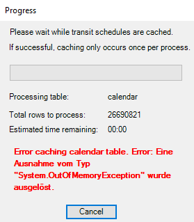
I excluded all the Network Locations except Streets_Use_This_one and enabled exclude restricted portions of the network. Also in the polygon generation tab i checked TransitLines and connectors as excluded sources.
What could be the reason for this to show up? And how can I prevent this error from happening?
Thanks to everyone, best regards, Tim
Solved! Go to Solution.
- Mark as New
- Bookmark
- Subscribe
- Mute
- Subscribe to RSS Feed
- Permalink
- Report Inappropriate Content
The network creation was sucessfull and it seems to work! I´ll have to run some more tests on it, but so far it seems pretty good.
I uploaded the GTFS in my google drive for you: Opendata DELFI.rar - Google Drive . Please let me know when you have downloaded it, so I can remove it.
- Mark as New
- Bookmark
- Subscribe
- Mute
- Subscribe to RSS Feed
- Permalink
- Report Inappropriate Content
Thank you! I have downloaded the data, so you can delete the share now.
I will play around with it and see if I can figure out why it is producing strange errors.
- Mark as New
- Bookmark
- Subscribe
- Mute
- Subscribe to RSS Feed
- Permalink
- Report Inappropriate Content
Just to follow up.
I ran GTFS To Network Dataset Transit Sources with your GTFS data. Looking at the output, I see the following:
These three rows in stops.txt have incorrect lat/lon values:
"000001042301","","Lengfeld, Themarer Straße",,"5.088988000000","1.112697000000",1,,,""
"000204230101","","Lengfeld, Themarer Straße",,"5.088988000000","1.112697000000",0,"000001042301",,""
"000204230102","","Lengfeld, Themarer Straße",,"5.088988000000","1.112697000000",0,"000001042301",,""
I'm guessing it should be 51.xxx and 11.xxx instead of 5.xxx and 1.xxx based on the lat/lon of the other stops. Right now these are placed off the coast of Africa.
These three rows in stops.txt have an incorrect longitude:
"de:03252:2800:1:1","","Hemeringen, Heinegras",,"52.127996000000","179.999997000000",0,"000000000037_G",,""
"de:03252:2800:1:2","","Hemeringen, Heinegras",,"52.127996000000","179.999997000000",0,"000000000037_G",,""
"000000000037_G","","Hemeringen, Heinegras",,"52.127996000000","179.999997000000",1,,,""
179.999 is still within the valid range of longitudes, so the tool did not throw an error, but these stops are out in the Pacific ocean.
However, none of these actually throw errors in that tool. I ran some python code mimicking the part of Connect Network Dataset Transit Sources To Streets that threw the error, and there were no errors. I cannot explain why you got errors. I am testing on the not-yet-released Pro 2.7, so it's possible that we have recently fixed a bug that caused the geometry errors in the first place. I'm not sure.
Anyway, from your previous comment, it sounds like your issue was resolved by running the Repair Geometry tool. If that's the case, I will give up on trying to make sense of this issue. Good luck with your thesis!
- Mark as New
- Bookmark
- Subscribe
- Mute
- Subscribe to RSS Feed
- Permalink
- Report Inappropriate Content
Hm, that´s strange. But doesnt´t matter for my analysis. Thank you very much for your time and help. Really appreciate it!
Best regards, Tim
- « Previous
-
- 1
- 2
- Next »
- « Previous
-
- 1
- 2
- Next »