- Home
- :
- All Communities
- :
- Products
- :
- Mapping
- :
- Mapping Questions
- :
- Labels showing through layers
- Subscribe to RSS Feed
- Mark Topic as New
- Mark Topic as Read
- Float this Topic for Current User
- Bookmark
- Subscribe
- Mute
- Printer Friendly Page
Labels showing through layers
- Mark as New
- Bookmark
- Subscribe
- Mute
- Subscribe to RSS Feed
- Permalink
Labels from several lower layers are showing up on top of upper layer(s) solid filled polygon(s). I have viewed the label and symbology properties for both, played with the placement properties, as well as created new polygon files, and the labels still show through. The only difference I can think of, is the labels that are showing are from imported MapInfo files. I am using ArcGIS for Desktop 10.2.2. Thank you for your help!
- Mark as New
- Bookmark
- Subscribe
- Mute
- Subscribe to RSS Feed
- Permalink
Hi, what you describe seems to be standard behaviour in ArcGIS. Labels from all vectors layers with enabled labels will draw on top of any other layers.
I don't think there is a way to change that.
F.
- Mark as New
- Bookmark
- Subscribe
- Mute
- Subscribe to RSS Feed
- Permalink
Yes, labels always draw above all feature layers. If you convert them to annotation you can drag the annotation layers below any features layers you want.
- Mark as New
- Bookmark
- Subscribe
- Mute
- Subscribe to RSS Feed
- Permalink
Hi Kathleen,
You could use Label weights in the labeling toolbar to define lower weights to the labels of the other features than the weight of the polygon feature on the top. You could use Maplex to avail more number of labeling priorities.
Thanks,
Jay
Think Location
- Mark as New
- Bookmark
- Subscribe
- Mute
- Subscribe to RSS Feed
- Permalink
Thank you everyone for your help. I tried all of your suggestions (label weights, labels to annotation, and maplex label engine), however none of the solutions worked. The only way I can see around it is to join the data sets to show points only within the cutout portion of the polygon. Albeit a bit time consuming. Thanks again.
- Mark as New
- Bookmark
- Subscribe
- Mute
- Subscribe to RSS Feed
- Permalink
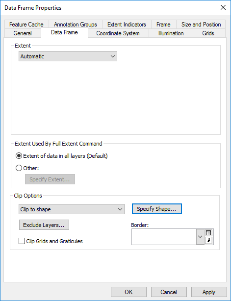
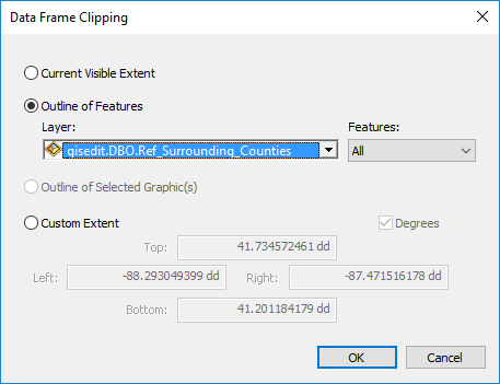
It's a bit late for Kathleen's question, but for future reference you can clip to layers in the data frame. For example, I'm always dealing with street labels hanging over the edges of a county boundary. One of two ways I found to clean these up are converting them to annotation in the map (as mentioned above), but this is way too time consuming with so many features. The other way is to 'clip to shape'. You can do this by double clicking the data frame you're working with --> Data Frame tab --> Clip to Shape --> and then there are a few options to clip to. I clipped to a polygon that doesn't cover anything within the county, only outside it-- Surrounding Counties.
- Mark as New
- Bookmark
- Subscribe
- Mute
- Subscribe to RSS Feed
- Permalink
Thanks Jared for this solution! This used to drive me crazy, but not anymore 
- Mark as New
- Bookmark
- Subscribe
- Mute
- Subscribe to RSS Feed
- Permalink
Funny thing is I found my label showed when it was at lower layer, but hid when it was at top layer. See below images.

