- Home
- :
- All Communities
- :
- Products
- :
- Mapping
- :
- Mapping Questions
- :
- Re: Is there an easy way to create inset maps?
- Subscribe to RSS Feed
- Mark Topic as New
- Mark Topic as Read
- Float this Topic for Current User
- Bookmark
- Subscribe
- Mute
- Printer Friendly Page
- Mark as New
- Bookmark
- Subscribe
- Mute
- Subscribe to RSS Feed
- Permalink
- Report Inappropriate Content
I need to create maps like the one attached, which contain many inset maps. The only way I know to create an inset map is to follow the directions at this link: Esri Mapping Centre - Ask a Cartographer The customer I'm supporting is not using arc gis currently and so will have to create many, many of these inset maps. Is there an easy way to do this? As you can see from the attachment, the inset maps are always just blown up areas of something visible in the map already. They are "zoomed in" windows to an area of interest. Sometimes there are several on one page.
If the customer uses the directions in the link above, it will takes a very long time to create these inset maps. They have hundreds to generate. If you have any ideas on how to make this easier, please let me know.
Solved! Go to Solution.
Accepted Solutions
- Mark as New
- Bookmark
- Subscribe
- Mute
- Subscribe to RSS Feed
- Permalink
- Report Inappropriate Content
I don't know enough about ArcObjects to help you with that, perhaps Xander Bakker might know of some add-ons or tools that can help you out for a dynamic way to create new data frames as an inset map.
If they were planning on manually creating the area of interest boxes in the map, I would suggest making some map templates, saved mxds that have multiple dataframes already built with the layers already loaded(they could be placed in the map template folder so they are an option when ArcMap opens). You could keep the extra dataframes out of the layout extent and they could bring them into the layout as needed, then they would just need to zoom in to the area they need in the inset map, then create the extent rectangles. Not quite as easy as their old draw the area of interest and click where you want the inset, but certainly better than starting from scratch each time.
- Mark as New
- Bookmark
- Subscribe
- Mute
- Subscribe to RSS Feed
- Permalink
- Report Inappropriate Content
Ted, your post was a bit confusing can they or can they not use ArcGIS? Also, what type of mapping are they needing to do, are they needing to zoom to various features of a layer, or add different layers, etc? I know for a project like this that I've done I made some template mxds, which could be accessed with python and you could add features you needed, or select the features you need and zoom to them on both the inset map(secondary dataframe(s)) and the main map(primary dataframe). My end result was a script tool where I could control the various text elements and add the layers I needed and it would make the changes to the template map with multiple dataframes, save it as a new map and export to pdf. Depending on the functionality you are needing(say you need to do 500 junction insets for a utility map, each with a certain ID number) you could make a script where it could do all of them at once, just have your template then have it select by attribute, zoom to feature, save as a new file name, then make the next one. You would likely have to do alot of spot checking and editting, but at least all your MXDs would be created and feature you need there with only editting needing to be done.
If you can give some more info about the project, it would probably be easier to find a good solution. Would you be needing one inset per map, multiple, or a variable number? Are we working with multiple layers for insets or singles?
- Mark as New
- Bookmark
- Subscribe
- Mute
- Subscribe to RSS Feed
- Permalink
- Report Inappropriate Content
I'm sorry for the confusion. The customer is moving from an old system to arc gis 10.2.1. They are used to being able to create as many inset maps as they feel they need, per page. Sometimes they don't put one on a page and sometimes there will be two or three of them on one page. The system they have now allows them to do this by drawing a box around the area to be magnified and then drawing another box where the inset map will go. If I could find an arc objects or python example of a tool that did this or something like it, that would be a great starting point. The customer's maps have many layers in them, not just one layer.
If the only way to do it is to make the inset maps as described in Esri Mapping Centre - Ask a Cartographer, then they will have to do it that way. I was just wondering if anyone has a less laborious way of creating inset maps, since they're going to have to create so many of them.
- Mark as New
- Bookmark
- Subscribe
- Mute
- Subscribe to RSS Feed
- Permalink
- Report Inappropriate Content
I don't know enough about ArcObjects to help you with that, perhaps Xander Bakker might know of some add-ons or tools that can help you out for a dynamic way to create new data frames as an inset map.
If they were planning on manually creating the area of interest boxes in the map, I would suggest making some map templates, saved mxds that have multiple dataframes already built with the layers already loaded(they could be placed in the map template folder so they are an option when ArcMap opens). You could keep the extra dataframes out of the layout extent and they could bring them into the layout as needed, then they would just need to zoom in to the area they need in the inset map, then create the extent rectangles. Not quite as easy as their old draw the area of interest and click where you want the inset, but certainly better than starting from scratch each time.
- Mark as New
- Bookmark
- Subscribe
- Mute
- Subscribe to RSS Feed
- Permalink
- Report Inappropriate Content
Thanks, that sounds like a good idea. This shows how little experience I have with making maps, but how do I keep a dataframe out of the layout extent and then bring it in as needed?
- Mark as New
- Bookmark
- Subscribe
- Mute
- Subscribe to RSS Feed
- Permalink
- Report Inappropriate Content
When you are in layout view, you all the objects on the "page" are visible on your map, objects that are outside of the page are not visible(extra text elements, legends, dataframes, etc.)
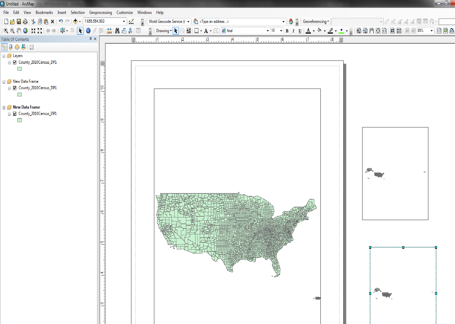
All you would have to do is select(click) on the dataframes that are outside the page and place them where you want on the map. You could then zoom to the area you need in those dataframes and create the bounding boxes from the instructions on the blog post. A template is good so instead of working with a blank map each time, you open a map with multiple data frames with all your layers already loaded and all you need to do is edit it to your purpose.
To have a map show up as a template when you open ArcMap, save your mxd file in the C < User < YourUserName < AppData < Roaming < ESRI <Desktop xx.x < ArcMap < Templates folder, the show up like the figure below when you open a new map document, those are the 3 map documents I have saved there.
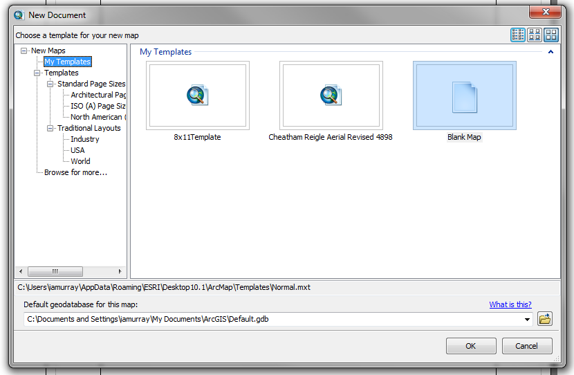
If they are in that folder, then when you save, it will automatically treat it as a save as, so you don't overwrite your template on accident
- Mark as New
- Bookmark
- Subscribe
- Mute
- Subscribe to RSS Feed
- Permalink
- Report Inappropriate Content
This is how I would have done it, using additional data frames inserted over the base map.
The maps look like they are for a utility. The insets are blowups to show more detail where the basemap scale does not allow the that much detail.
If the data sets in the inset data frames are the same as that of the main data frame, you can copy the basemap data frame, paste it, and then resize and reposition it and make sure it is in front of the basemap.
- Mark as New
- Bookmark
- Subscribe
- Mute
- Subscribe to RSS Feed
- Permalink
- Report Inappropriate Content
Also if you add some tags to the original post, people would be able to find and filter to this discussion easier.
- Mark as New
- Bookmark
- Subscribe
- Mute
- Subscribe to RSS Feed
- Permalink
- Report Inappropriate Content
Have you thought about making a map book? not exactly an inset map, but is another option, especially in areas with a lot of details, and far quicker than making tons of inset maps.