- Home
- :
- All Communities
- :
- Products
- :
- Mapping
- :
- Mapping Questions
- :
- How to change the unit of Extent in Source tab of ...
- Subscribe to RSS Feed
- Mark Topic as New
- Mark Topic as Read
- Float this Topic for Current User
- Bookmark
- Subscribe
- Mute
- Printer Friendly Page
How to change the unit of Extent in Source tab of Layer properties?
- Mark as New
- Bookmark
- Subscribe
- Mute
- Subscribe to RSS Feed
- Permalink
- Report Inappropriate Content
Maybe basic question on the unit of coordination system, m or degree?
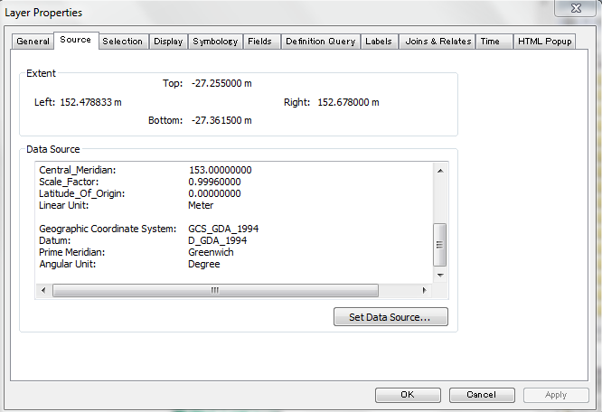
I have made one shapefile of points with FID, Shape*, Latitude and Longitude. I tried to show these points in a map, however, the points are not displayed. I checked the property of the shapefile and found that the unit of Extent in Source tab of Layer properties are "m", besides the actual data in the shapefile is "degree". Please find the attachment in detail.
I have found similar questions in the forum, but the answers did not address this problem.
Thank you for your answers in advance.
Yoshi
Solved! Go to Solution.
Accepted Solutions
- Mark as New
- Bookmark
- Subscribe
- Mute
- Subscribe to RSS Feed
- Permalink
- Report Inappropriate Content
Hi Yoshi,
It is a coordinate system problem. Currently, this layer has a projected coordinate system assigned to it. Based on the screen shot, probably MGA zone 56. Use the data's property page in ArcCatalog or the Define Projection Tool in ArcToolbox to redefine the coordinate system to a geographic one like GDA 1994 (since the data's in Australia). Once you have it defined correctly, you can have ArcMap project it on-the-fly to that MGA zone, or use the Project Tool to create a copy of the data that is georeferenced to a projected coordinate system.
Melita
P.S. If you get a chance, could you add some tags to your question? That might help someone else with a similar problem find this question. Thanks!
- Mark as New
- Bookmark
- Subscribe
- Mute
- Subscribe to RSS Feed
- Permalink
- Report Inappropriate Content
Hi Melita
Thank you for your advice, the problem could be fixed by changing the coordination systems. I thought the shape file is newly developed and incorporated into the project, therefore, I did not care about the coordination system setting. But changing the coordination systems to GDA1994, the points could be displayed on the map.
Yoshi