- Home
- :
- All Communities
- :
- Products
- :
- Mapping
- :
- Mapping Questions
- :
- Re: Does anyone know if there is a modern day vers...
- Subscribe to RSS Feed
- Mark Topic as New
- Mark Topic as Read
- Float this Topic for Current User
- Bookmark
- Subscribe
- Mute
- Printer Friendly Page
Does anyone know if there is a modern day version of a region coverage?
- Mark as New
- Bookmark
- Subscribe
- Mute
- Subscribe to RSS Feed
- Permalink
- Report Inappropriate Content
"Back in the day" there was something called a region that allowed you to symbolize multiple features as one feature based on an attribute. For example, symbolizing the contiguous United States as one polygon instead of 48 individual polygons without creating a new dataset. Does something like this still exist?
- Mark as New
- Bookmark
- Subscribe
- Mute
- Subscribe to RSS Feed
- Permalink
- Report Inappropriate Content
Technically, regions are still a part of the archaic "coverage" format, but the performance cost of the shared geometry model of coverages has driven them from the marketplace (by definition, polygon, route, and region I/O cost is at least twice that of the "whole shape" model -- It takes one pass to read the file blocks to determine storage, and a second pass to fill the allocated vertex buffer) .
- V
- Mark as New
- Bookmark
- Subscribe
- Mute
- Subscribe to RSS Feed
- Permalink
- Report Inappropriate Content
Basically the old region is just a multipart polygon Creating a multipart feature—Help | ArcGIS for Desktop
How I handle it is although my master gdb with topology may have an issue with storing many of my old "region" features, if I have fields that that I can select on, I can recreate them as needed. I typically export my master (three FCs) to a FGDB as needed, then create a series of FC with my python scripts to recreate the regions. Also I make heavy use of "domains" and subclasses. Best of both worlds.
If you need the ability to recreate the region symbology for arcs, I have a script that looks at values and the old left/right values from coverages to reclass the shared arcs.....but that is on a FC that does not have overlapping features to start with.
That is how I rebuild my region features (which was the best thing since sliced bread, back when it was released!)
- Mark as New
- Bookmark
- Subscribe
- Mute
- Subscribe to RSS Feed
- Permalink
- Report Inappropriate Content
Regions could be used to implement a multipart polygon, but they could also be used to implement multiple overlapping single-part polygons (successive features). They were defined by routes (which were collections of arcs).
Yeah, it was pretty amazing to pile all that information into one set of INFO tables, but, Oy!, pulling it back out again was a nightmare.
- Mark as New
- Bookmark
- Subscribe
- Mute
- Subscribe to RSS Feed
- Permalink
- Report Inappropriate Content
 But they sure were handy! For quite a while, when I was first converting my 27 coverages to SDE I was thinking I could at least retain the arc region features I had. But as soon as I did my first edit of my 3-poly and the 1-arc (polyline) features I had in my topology, I knew that was a mistake. There was no way I could easily maintain all the relationships I had with the arc and polys. That's why I ended up with the 3 polygon features classes involved in the topology, and spin off the rest about once a month (including the arcs from one of them).
It could be that representation could work for Ted too.....but I haven't used them much personally need them for other things than just plotting. What are representations?—Help | ArcGIS for Desktop
- Mark as New
- Bookmark
- Subscribe
- Mute
- Subscribe to RSS Feed
- Permalink
- Report Inappropriate Content
I probably muddied the waters a bit by using the States and an example. My actual dataset is a line feature. Specifically transmission lines drawn from tower to tower. I would like to keep my data segmented at the lowest level and then present the data to users aggregated into larger features. So, for transmission lines, spans (tower to tower) are part of segments. Segments make up Sections and Sections make up Circuits.
Rebecca, your script may help me with this. The only other alternative I can think of is running a batchfile every so often to recreate layers by dissolving based on attributes; not something I really want to do.
- Mark as New
- Bookmark
- Subscribe
- Mute
- Subscribe to RSS Feed
- Permalink
- Report Inappropriate Content
Ted, I followed you, so if you follow me you can send me a DM. If you think any of my python scripts would help, I can send a couple.
Fair warning....
- most were written in 2010, with updates since....but still might have some older, less efficient code.
- some processes require an ArcInfo/Advanced license
- It is a very customized set of scripts for our datasets, so although concepts might work for you, you would have to customize it for your data
- My arc-region rebuild it is based on polygons and the polylines between then, so may not be what you are lookng for.
- I also use quite a few arcpy.Dissolve_management based on subtypes to recreate the region features....I could send one of those scripts as well, just so you can see how I do it.
Again, these would not be OTB running script fo you, but might give you some ideas. However, maybe some of the above notes might help just as much. (?)
- Mark as New
- Bookmark
- Subscribe
- Mute
- Subscribe to RSS Feed
- Permalink
- Report Inappropriate Content
ok.. dumb question... how do I send a DM? 
- Mark as New
- Bookmark
- Subscribe
- Mute
- Subscribe to RSS Feed
- Permalink
- Report Inappropriate Content
ONE way, if you hover over my avatar or name a in one of my response...a window should pop-up and the Follow and the Message buttons should be under my picture. (since it is a popup, can't show a screen click.
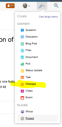
Another way is to use the pulldown under the pencil at the top right and click message
you should be able to start typing my name...or click the "people" button to the right and I think that brings up people you follow or that follow you (can't remember).
- Mark as New
- Bookmark
- Subscribe
- Mute
- Subscribe to RSS Feed
- Permalink
- Report Inappropriate Content
Ah, the good old coverage format...
No messing with topology rules, because it was all built in.