- Home
- :
- All Communities
- :
- User Groups
- :
- Local Government Solutions Users
- :
- Questions
- :
- Re: Parcel Drafter setup question
- Subscribe to RSS Feed
- Mark Topic as New
- Mark Topic as Read
- Float this Topic for Current User
- Bookmark
- Subscribe
- Mute
- Printer Friendly Page
Parcel Drafter setup question
- Mark as New
- Bookmark
- Subscribe
- Mute
- Subscribe to RSS Feed
- Permalink
- Report Inappropriate Content
I deployed the Parcel Drafter solution via ArcPro and am trying to get it set up. Is the list of snapping layers expecting an actual Parcel Fabric feature that has been published? When I try to add the published version of our PLSS control points, for instance, I get an "invalid foreign key" error, leading me to believe that perhaps it's expecting a very specific schema and not just any old layer.
- Mark as New
- Bookmark
- Subscribe
- Mute
- Subscribe to RSS Feed
- Permalink
- Report Inappropriate Content
Yes, this is strange - does the line feature layer have a relateGUID field?
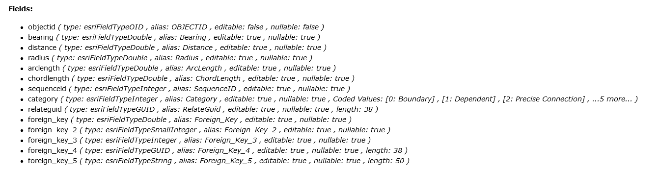
- OBJECTID (type: esriFieldTypeOID, alias: OBJECTID, SQL Type: sqlTypeOther, length: 0, nullable: false, editable: false)
- Bearing (type: esriFieldTypeDouble, alias: Bearing, SQL Type: sqlTypeOther, nullable: true, editable: true)
- Distance (type: esriFieldTypeDouble, alias: Distance, SQL Type: sqlTypeOther, nullable: true, editable: true)
- Radius (type: esriFieldTypeDouble, alias: Radius, SQL Type: sqlTypeOther, nullable: true, editable: true)
- ArcLength (type: esriFieldTypeDouble, alias: ArcLength, SQL Type: sqlTypeOther, nullable: true, editable: true)
- ChordLength (type: esriFieldTypeDouble, alias: ChordLength, SQL Type: sqlTypeOther, nullable: true, editable: true)
- SequenceID (type: esriFieldTypeInteger, alias: SequenceID, SQL Type: sqlTypeOther, nullable: true, editable: true)
- Category (type: esriFieldTypeInteger, alias: Category, SQL Type: sqlTypeOther, nullable: true, editable: true)
- RelateGuid (type: esriFieldTypeGUID, alias: RelateGuid, SQL Type: sqlTypeOther, length: 38, nullable: true, editable: true)
- Shape__Length (type: esriFieldTypeDouble, alias: Shape__Length, SQL Type: sqlTypeDouble, nullable: true, editable: false)
- Mark as New
- Bookmark
- Subscribe
- Mute
- Subscribe to RSS Feed
- Permalink
- Report Inappropriate Content
Yes, the line layer already had the RelateGuid filed set up when I downloaded it from ESRI.
- Mark as New
- Bookmark
- Subscribe
- Mute
- Subscribe to RSS Feed
- Permalink
- Report Inappropriate Content
Can you please send me a screenshot of your rest endpoint showing the fields as shown above? What DBMS are you using, oracle?
- Mark as New
- Bookmark
- Subscribe
- Mute
- Subscribe to RSS Feed
- Permalink
- Report Inappropriate Content
Yes, Oracle DB.
- Mark as New
- Bookmark
- Subscribe
- Mute
- Subscribe to RSS Feed
- Permalink
- Report Inappropriate Content
Angelo,
I think that you uncovered a bug, the widget may be looking for a camelcase "RelateGuid" field in the lines layer - instead, Oracle DB is changing it to be relateguid - all lowercase.
Using the AGO Assistant - you can manually change the name of the field in the application json.
Data Section -
"relatedGUID": {
"name": "RelateGuid",
"type": "esriFieldTypeGUID",
"alias": "RelateGuid",
"length": 38,
"editable": true,
"nullable": true
},
- Mark as New
- Bookmark
- Subscribe
- Mute
- Subscribe to RSS Feed
- Permalink
- Report Inappropriate Content
Chris,
Thank you for helping us identify the issue!
- Mark as New
- Bookmark
- Subscribe
- Mute
- Subscribe to RSS Feed
- Permalink
- Report Inappropriate Content
Angelo -
Did this resolve the issue?
Thanks
Chris
- Mark as New
- Bookmark
- Subscribe
- Mute
- Subscribe to RSS Feed
- Permalink
- Report Inappropriate Content
Hi all,
Here's my solution to the foreign key error. 3 years later, but who knows, it might help someone 🙂
-----Layer preparation for Parcel Drafter-----
Create a file geodatabase and create the following layers:
- Line layer:
- Bearing (double)
- Distance (double)
- Radius (double)
- ArcLength (double)
- ChordLength (double)
- SequenceID (double)
- Note: SequenceID has to be entered as written, otherwise the attribute won’t be recognized in the parcel drafter tool.
- LineType (double)
- Polygon layer:
- Rotation (double)
- ClosingRate (double)
- Zone (Text)
- Scale (double)
- ClosingDistance (double)
- Relation class between the two layers:
- Origin table: the Polygon layer
- Destination table: the line layer
- Note: The relation must be from the polygon to the line, otherwise there won’t be a foreign key and you would get the “Invalid foreign key” error.
- Origin Foreign key is the objectID
Share layers to portal
To Keep the relation when uploading the layers, you must publish the layers from a map containing only the related layers. To make sure the relation is active, check that there is a relation in the “relates” tab of the properties of each layer.
Click on the share tab and in the share as group, click on web layer and then publish web layer. See this post for more details.
In the sharing options, you must share the layer as a hosted layer (under “copy all data”, select “feature”). If you reference the layer, you will have an “invalid foreign key” error.
If you have done this step correctly, you should have one feature layer in your portal content, which has the 2 layers in it.
Set up the parcel drafter tool
In the parcel drafter tool, select the wanted polygon layer. Some fields should automatically be completed. If you have followed every step, you should have a foreign key and Sequence ID already filled in. Fill in the connection line and limit line values with 0 and 1.
Complete the set up by choosing the attributes corresponding to the COGO values and add fields for the geometry information of the coordinates.
- « Previous
-
- 1
- 2
- Next »
- « Previous
-
- 1
- 2
- Next »