- Home
- :
- All Communities
- :
- User Groups
- :
- LIDAR Resources
- :
- Questions
- :
- Re: Reprojecting LAS datasets using Extract LAS To...
- Subscribe to RSS Feed
- Mark Topic as New
- Mark Topic as Read
- Float this Topic for Current User
- Bookmark
- Subscribe
- Mute
- Printer Friendly Page
Reprojecting LAS datasets using Extract LAS Tool not transforming Z values
- Mark as New
- Bookmark
- Subscribe
- Mute
- Subscribe to RSS Feed
- Permalink
- Report Inappropriate Content
I am trying to reproject LAS datasets derived from Pix4D photogrammetry output of a UAV flight that were created with the WGS_1984_UTM_Zone_17N / VCS:WGS_1984 (Z unit is meters above ellipsoid) spatial reference so that it can align with other third-party LAS dataset (traditional lidar; not photogrammetry) in the NAD_1983_StatePlane_Pennsylvania_South_FIPS_3702_Feet / VCS:NAVD88_height_ (Z unit is Ft_US) spatial reference.
The Extract LAS (3D Analyst)—ArcGIS Pro | Documentation, it explains that the LAS data can be reprojected using the Output Coordinate System environment and it is claimed:
'If the spatial reference contains a vertical coordinate system, the LAS files can also be reprojected to another height reference system if the vertical datum transformation grids are installed and a transformation is available from the source reference and the target coordinate system.'
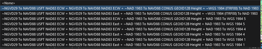
I have the Coordinate System for ArcGIS grids installed and the appropriate transformation is set in the Map/Scene Properties and everything is projected on-the-fly brilliantly in the map and scenes when viewed. The highlighted transformation below is what is selected in the Map/Scene Properties > Transformation for the above coordinate systems.
However, I cannot set the Geographic Transformation environment setting to match the above compound transformation, so I left it blank hoping the software would choose the appropriate XY and Z transformations. However, the Geographic Transformations (Environment setting)—ArcGIS Pro | Documentation says that 'compound transformations' are not valid in the environment setting (which makes me think that this particular transformation is not possible in this tool).
So, when I run the Extract LAS tool, the vertical location of the points are not transformed/reprojected (while the horizontally they are), and instead appear to be located in the original Z coordinate system, which in this case is below the expected vertical location.
So is the claim that the Z coordinate system for LAS data can be reprojected false? Am I missing something? Any guidance would be appreciated. This will likely be mission critical for me. Thanks.
- Mark as New
- Bookmark
- Subscribe
- Mute
- Subscribe to RSS Feed
- Permalink
- Report Inappropriate Content
This can be tricky within the Esri software environment. Are you able to use LAStools?
This will do the job without the headache. Depending on your preferences, the CLI can be easier to use for setting VCS if they do not show up in the GUI.
- Mark as New
- Bookmark
- Subscribe
- Mute
- Subscribe to RSS Feed
- Permalink
- Report Inappropriate Content
Please do provide a CLI example using (LASTools) las2las.exe going from WGS_1984_UTM_Zone_17N / VCS:WGS_1984 to NAD_1983_StatePlane_Pennsylvania_South_FIPS_3702_Feet / VCS:NAVD88_height_ (Z unit is Ft_US). Extra credit if you include Geoid 18
- Mark as New
- Bookmark
- Subscribe
- Mute
- Subscribe to RSS Feed
- Permalink
- Report Inappropriate Content
I took a shot at your request and was able to produce decent results using the following command:
D:\LAStools\bin>las2las -i ..\PAUTMv1\PA_UTMtoNAD83.las
-vertical_navd88_geoid12b
-set_ogc_wkt -target_sp83 PA_S
-target_feet -target_elevation_feet -target_precision 0.001
-odix _PA_S_foot -olas
Run LASInfo to see WKT OGC CS details.
I will take a look later this week to work in NAD 83 FIPS instead of NAD 83 and Geoid18 instead of Geoid12b. This should get you started.
As far as I can tell, you can achieve the same results (except for baking the Geoid in the header) using the "Extract LAS" tool in ArcGIS Pro and set your CS/transformation in Environments.
- Mark as New
- Bookmark
- Subscribe
- Mute
- Subscribe to RSS Feed
- Permalink
- Report Inappropriate Content
Great job. Now others can benefit from having an example available.