- Home
- :
- All Communities
- :
- User Groups
- :
- LIDAR Resources
- :
- Questions
- :
- Re: Looking for a more efficient way to create a s...
- Subscribe to RSS Feed
- Mark Topic as New
- Mark Topic as Read
- Float this Topic for Current User
- Bookmark
- Subscribe
- Mute
- Printer Friendly Page
Looking for a more efficient way to create a soft clip for Lidar data.
- Mark as New
- Bookmark
- Subscribe
- Mute
- Subscribe to RSS Feed
- Permalink
- Report Inappropriate Content
I have some older lidar data that was collected in some irregular shapes. I'm creating some terrains for this data from the multipoint data and would like to avoid triangulation across concave edges by using an outline polygon feature class as a soft clip. What I have been doing is buffering the multipoints by a positive distance, dissolving any internal polygons that were created, then buffering the new polygon by same distance as step 1, but a negative number. The problem is that the first step, buffering the multipoints, can take a long time for big files. Is there a more efficient method? For some of these multipoints files and in cases where I'm going to use several adjacent multipoint files in the same terrain, I think I might find that just digitizing an outline might be more efficient than my buffering method has been.
Solved! Go to Solution.
Accepted Solutions
- Mark as New
- Bookmark
- Subscribe
- Mute
- Subscribe to RSS Feed
- Permalink
- Report Inappropriate Content
Hi Paul,
Have you gone through this workflow about Data area delineation from lidar points? Is this something you were looking for?
Thanks,
Prasanta.
- Mark as New
- Bookmark
- Subscribe
- Mute
- Subscribe to RSS Feed
- Permalink
- Report Inappropriate Content
Hi Paul,
Have you gone through this workflow about Data area delineation from lidar points? Is this something you were looking for?
Thanks,
Prasanta.
- Mark as New
- Bookmark
- Subscribe
- Mute
- Subscribe to RSS Feed
- Permalink
- Report Inappropriate Content
Oh, Thanks, I was looking for something like this. I was eager to try this, so I opened up my last project and was dismayed that one of the LIDAR sets I was using was delivered way, way, back in 2000. There were no LAS sets delivered. My first step had been ASCII 3D to Feature Class to get a multipoint feature class.
I'll for sure try out the workflow you pointed out on my more recent LIDAR lidar data that was delivered with LAS data. But for now, I still haven't figured out a better way to get an outline polygon from this older data than to buffer the multipoints.
- Mark as New
- Bookmark
- Subscribe
- Mute
- Subscribe to RSS Feed
- Permalink
- Report Inappropriate Content
Have you looked at the "Minimum bounding geometry" tool. But that is probably not going to solve your problem with concave boundaries.
Can you thin the input points or subset them so that you can use a Tin instead of a Terrain. Then you have the "Deliniate Tin Data Area" tool
- Mark as New
- Bookmark
- Subscribe
- Mute
- Subscribe to RSS Feed
- Permalink
- Report Inappropriate Content
You can also try:
Point to Raster (using multipoints) > Expand/Shrink (to fill in the voids) > Raster to polygon.
- Mark as New
- Bookmark
- Subscribe
- Mute
- Subscribe to RSS Feed
- Permalink
- Report Inappropriate Content
Tried Point to Raster and the run time is trivial. So much better performance than trying to buffer the points. I'm guessing that the Value Field should be PointCount to make it equivalent to the LAS Point Statistics As Raster method set to Point_Count.
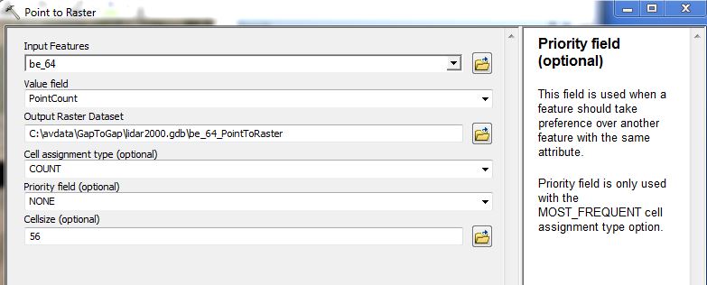
I set the cell size here to 4 times my average point spacing.
My test data set has a area of no points up the middle from a stream, so I have been trying Expand number of cells to around 5.
I could assemble these steps into a model or script if I were going to do this a lot.