- Home
- :
- All Communities
- :
- Learning
- :
- ArcGIS Tutorials
- :
- ArcGIS Tutorials Questions
- :
- Re: Solar Panel Suitability analysis, INTERSECT TO...
- Subscribe to RSS Feed
- Mark Topic as New
- Mark Topic as Read
- Float this Topic for Current User
- Bookmark
- Subscribe
- Mute
- Printer Friendly Page
Solar Panel Suitability analysis, INTERSECT TOOL help
- Mark as New
- Bookmark
- Subscribe
- Mute
- Subscribe to RSS Feed
- Permalink
- Report Inappropriate Content
I am creating a suitability analysis for solar panels around the area I live. The issue I am having is running the INTERSECT tool to find the areas that meet all of the correct criteria. However, the intersect tool requires the inputs be feature classes, and I have "File Geodatabase Raster Datasets" instead (three different rasters that show solar intensity, slope, and aspect). I tried converting these rasters using the "raster to polygon" tool but that didn't work because that tool only converts "File system rasters" and not "File Geodatabase Raster Datasets". The reason I want to convert the rasters to polygons is so that I can run the intersect tool.
BOTTOM LINE: Is there anyway I can run a tool like intersect on my 3 "File Geodatabase Raster Datasets" OR is there a tool that will let me convert these specific rasters into feature classes?
My work flow is as follows:
- Download a topographic map on my hometown from USGS
- Download a land-use map from USGS (that I may use to further narrow down my suitability results)
- Project the coordinate system of the topographic map to the coordinate system of the land-use map so that they match.
- Convert the topographic map to a DEM using the "topo to raster" tool
- Create a aspect map using the DEM as the input.
- Create a slope map using the DEM as the input.
- Create a solar intensity map using the "area solar radiation" tool with the DEM as the input
- HERE IS WHERE I AM HAVING TROUBLE.
- I want to use the interest tool to see where the aspect, slope, and solar intensity layers intersect. However, I can't use the intersect tool because these 3 layers are not feature classes (which the interest tool uses as the inputs). I tried converting them to feature classes but couldn't because they don't show up as available inputs in the "raster to polygon" tool.
- Is there some way I could use the "RASTER CALCULATOR" It seems like a viable option, but I'm still not very good at using the calculator.
- I tried the flowing string: "Solar_intensity_raster" + "slope raster" + "aspect raster" and it got me close, but the raster it created made some areas viable for solar panels, when they are not.
- I thought about creating a string something like this: ""solar_intensity_raster" > 400,000" + ""slope_raster" < 35" + ""aspect_raster" == south"" but i'm still inexperienced and am not sure how to correctly type this out.
Any recommendations?
- Mark as New
- Bookmark
- Subscribe
- Mute
- Subscribe to RSS Feed
- Permalink
- Report Inappropriate Content
Have you recomputed/reclassified the rasters to a suitability value? doing any kind of operations between the rasters without this is like adding apples and oranges, it's almost meaningless.
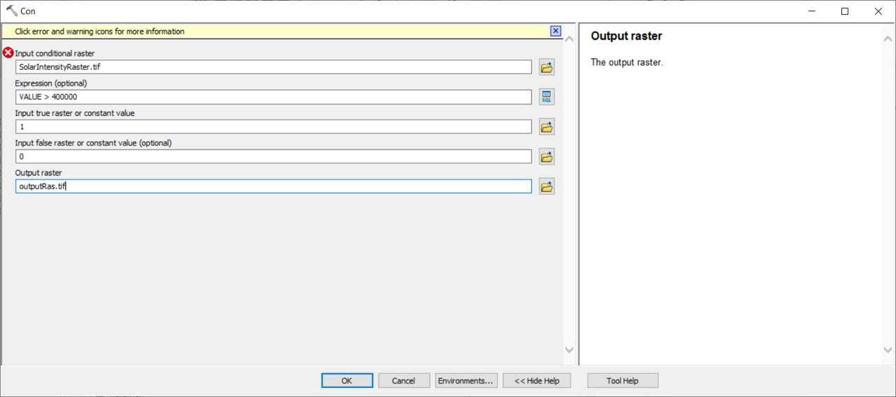
Try using the Con tool or Con in Raster Calculator to sort out your inputs first. You can of course do everything in one go in Raster Calc, but I wouldn't advise it if you're not completely familiar with it.
Turn values over 400000 to 1, else turn to 0:
- Mark as New
- Bookmark
- Subscribe
- Mute
- Subscribe to RSS Feed
- Permalink
- Report Inappropriate Content
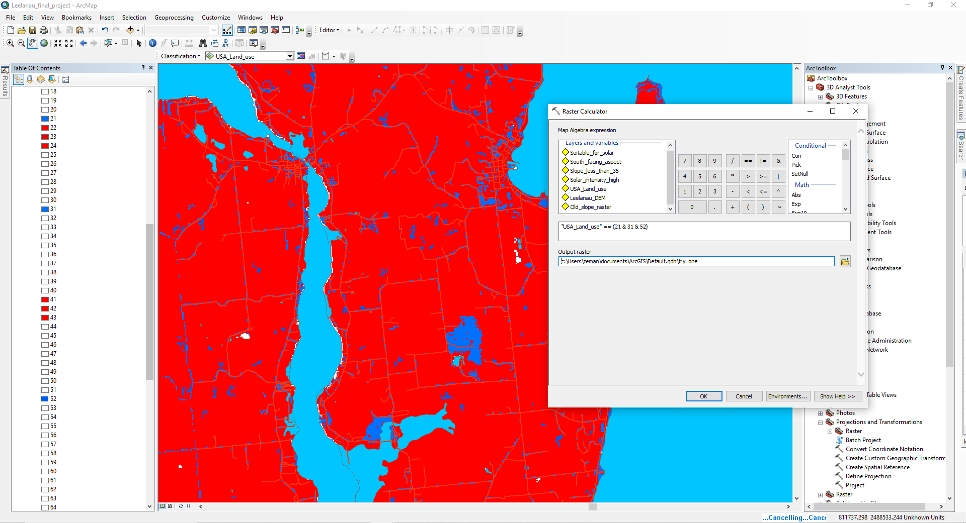
Thank you, that was very helpful. I was able to use the con tool to narrow down and then "intersect" my results. To further narrow down my search I've added a land use classification raster. I'm trying to use the con tool or the raster calculator to make it so that land classes that can't have solar panels are not included in the analysis. However, my knowledge of SQL is lacking and I can't form a correct SQL command (yet). I attached a picture to show you what I'm trying to do.
I only want to include the blue values in my analysis (and remove the red values). The white values have nothing in them. There are only three blue values - 21, 31, and 52. My SQL command is "USA_Land_use" == (21 & 31 & 52)
Any suggestions on how I might improve my SQL command?