- Home
- :
- All Communities
- :
- Learning
- :
- ArcGIS Tutorials
- :
- ArcGIS Tutorials Blog
- :
- What's new in Learn ArcGIS September 2020
What's new in Learn ArcGIS September 2020
- Subscribe to RSS Feed
- Mark as New
- Mark as Read
- Bookmark
- Subscribe
- Printer Friendly Page
- Report Inappropriate Content
New Pages
 We've got a new home page aimed at getting visitors to the appropriate content quickly via experiences and capabilities. Check it out!
 We've got a new page for K-12 educators just starting with GIS. Check it out!
New Learn Paths
A Learn Path is sequenced set of resources for learning about a particular topic. Here's a roundup of new paths in the Learn ArcGIS Gallery that have appeared in the last month.
 Make a map in a minute
Learn how to make a map in a minute (or less) using ArcGIS Online and ArcGIS Living Atlas of the World.
 GIS for population and development studies: Data analysis and visualization
Learn advanced spatial analysis and cartographic techniques.
New Learn Lessons
A Learn Lesson is a step-by-step tutorial that uses a real-world scenario to introduce key ArcGIS tools and workflows. Here's a roundup of new lessons in the Learn ArcGIS Gallery that have appeared in the last month.
 Validate edits in the utility network with attribute rules (ArcGIS Pro)
In this project, your role is as a GIS Analyst who has started working with an organisations electric utility network in ArcGIS Pro. Over the past few months, you've noticed certain irregularities with edits made to the peak load attributes of services in the network while performing regular QA/QC processes. After discussing the problem with your colleagues, you've decided to implement new attribute rules to prevent certain types of edits and to create a log that can be shared for monitoring and analysis of the edits made to the features.
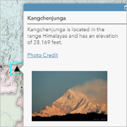 Map the highest mountains
A web map can include descriptive information about features in a pop-up. The information that appears when a feature is clicked can include text, images, and links to web pages. As a map maker, you decide what information to include and how to present it. In this lesson, you'll create a .csv file with data about five of the highest mountains in the world. You'll use the file to create a layer on a map. Then, you'll customize the layer's pop-ups so that when you click a mountain feature, you will see key information and a photo of the mountain.
This lesson, adapted from one developed for middle and high school students, is making its debut in the Learn Gallery. You can find it and others like it by searching the tag "teachgis" in the Gallery search bar.
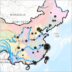
In this lesson, you'll make a map of China. Along the way, you'll copy and save a map; navigate around a map; and arrange, filter, and style layers.
This lesson, adapted from one developed for middle and high school students, is making its debut in the Learn Gallery. You can find it and others like it by searching the tag "teachgis" in the Gallery search bar.
Updated Lessons
The Learn ArcGIS Team updates lessons for the latest version of software products. Here's a round up of lessons that were updated to new software versions.
- Actionable intelligence (ArcGIS Pro 2.6)
- Analyze the global oil market (ArcGIS Online June 2020, ArcGIS Pro 2.6)
- Build a model to connect mountain lion habitat (ArcGIS Pro 2.6)
- Design and publish basemaps (ArcGIS Pro 2.6)
- Estimate solar power potential(ArcGIS Pro 2.6)
- Explore NOAA's deep-sea coral database (ArcGIS Pro 2.6)
- Fly through South America in a 3D animation (ArcGIS Pro 2.6)
- Interpolate 3D oxygen measurements in Monterey Bay (ArcGIS Pro 2.6, new section)
- Map breast cancer differences by ethnicity in ArcGIS Pro (ArcGIS Pro 2.6)
- Mapping the public garden in ArcGIS Pro (ArcGIS Online June 2020)
- Mapping the public garden in ArcMap (ArcGIS Online June 2020)
- Monitor whales with a multilingual survey (ArcGIS Online June 2020, ArcGIS Survey 123 3.1)
- The power of maps (ArcGIS Online June 2020)
- Understand the refugee crisis with link analysis (ArcGIS Insights 2020.2)
- Use species distribution patterns to assess protected areas (ArcGIS Online June 2020)
You must be a registered user to add a comment. If you've already registered, sign in. Otherwise, register and sign in.