- Home
- :
- All Communities
- :
- Learning
- :
- ArcGIS Tutorials
- :
- ArcGIS Tutorials Blog
- :
- What's New in Learn ArcGIS July 2022
What's New in Learn ArcGIS July 2022
- Subscribe to RSS Feed
- Mark as New
- Mark as Read
- Bookmark
- Subscribe
- Printer Friendly Page
- Report Inappropriate Content
Borrow attributes with a spatial join (ArcGIS Pro Basic)
Convert text data to numeric data (ArcGIS Pro Basic)

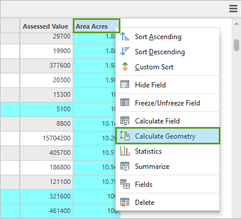
In this lesson, you'll create new numeric fields and populate them with the data from the text fields. You'll learn how to choose a field type and how to calculate fields.
Create a social equity index to improve public health (ArcGIS Pro)

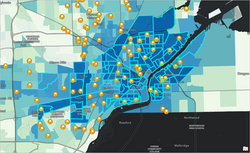
In this lesson, you are a GIS analyst tasked by your organization with improving respiratory health by identifying the areas in your community that would most benefit from increased funding for respiratory health educational programs, at-home air filtration systems, and other interventions to reduce and manage childhood asthma rates. To accomplish this, you will create a social equity index map that ranks each census block group in Lucas County, Ohio, in order of priority, based on 12 of the demographic indicators identified in collaboration with local residents. The resulting map with this index would help decision makers find locations where additional resource allocation would have the highest impact.
Customize a climate resilience index (ArcGIS Online)

In this lesson, you are a resilience planner for Miami-Dade County in Florida looking for ways to address extreme heat in your community. One of several options, or interventions, you will consider is opening cooling centers. Cooling centers are public spaces in the community with air conditioning, cold water, and other amenities that offer protection against the health effects of extreme heat. To meet city goals, you want to understand where cooling centers should be located to support the most vulnerable and historically underserved communities in the county.
Copy features between layers (ArcGIS Pro Basic)

In this lesson, you have a layer of building footprints for a neighborhood in Boulder, Colorado, U.S.A. The layer is missing some buildings, so you'll copy and paste features from another layer. You'll learn how to use some of the ArcGIS Pro editing tools, including Paste Special and the Attributes pane.
Run geoprocessing tools with Python(ArcGIS Pro)
 Running a geoprocessing tool in Python requires a good understanding of the tool’s syntax, including both required and optional parameters. In this lesson, you will practice running geoprocessing tools in the Python window. This lesson will demonstrate how to write Python code with correct syntax to run geoprocessing tools.
You must be a registered user to add a comment. If you've already registered, sign in. Otherwise, register and sign in.
