- Home
- :
- All Communities
- :
- Learning
- :
- ArcGIS Tutorials
- :
- ArcGIS Tutorials Blog
- :
- Day 11: Sustainability and GIS - 12 Days of GIS
Day 11: Sustainability and GIS - 12 Days of GIS
- Subscribe to RSS Feed
- Mark as New
- Mark as Read
- Bookmark
- Subscribe
- Printer Friendly Page
- Report Inappropriate Content
Day 11: Sustainability and GIS - 12 Days of GIS
GIS plays an important role in building sustainability and resilience. With the help of GIS, we can build solutions for a sustainable future and implement them from a local to a global level.
Today we invite you to explore the SDG Geospatial Learning Lab which offers various resources on how to use ArcGIS applications to take action on the 17 SDG objectives. These readily available resources are free to use for all.
A glance at a few tutorials to help you get started with GIS in Sustainability:

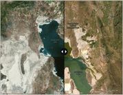
Use the World Imagery Wayback app to create a story with swipe maps and visualize the extent of lake shrinkage due to severe droughts.
Level: Beginner
Software: None
Perform a site suitability analysis for a new wind farm
Determine the optimal location for a set of new high-efficiency wind turbines in Colorado.
Level: Intermediate
Software: ArcGIS Online
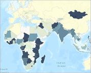
Use United Nations Sustainable Development Goal data to compare hunger in the forms of undernourishment and food insecurity for the world's population.
Level: Beginner
Software: ArcGIS Online
And don’t forget the GIS-themed Wordle of the day
Interested in hosting your own event for GIS Day? Gather your community and explore all things GIS. Register for your event and receive support and software donations! Learn more about registering for your event.
You must be a registered user to add a comment. If you've already registered, sign in. Otherwise, register and sign in.

