- Home
- :
- All Communities
- :
- Industries
- :
- Land Records and Valuation
- :
- Land Records and Valuation Questions
- :
- Tricky Acreage Calculation
- Subscribe to RSS Feed
- Mark Topic as New
- Mark Topic as Read
- Float this Topic for Current User
- Bookmark
- Subscribe
- Mute
- Printer Friendly Page
Tricky Acreage Calculation
- Mark as New
- Bookmark
- Subscribe
- Mute
- Subscribe to RSS Feed
- Permalink
- Report Inappropriate Content
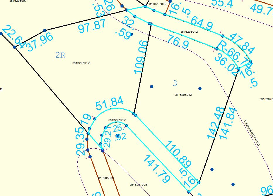
The two highlighted polygons in the image are pieces of vacated right-of-way. I need to determine the amount of acreage of each of those polygons to assign to Lot 2R and to Lot 3. The dimension annotations are true per the recorded surveys of the land. However, the actual length of the lines when measured in ArcMap do not match the surveyed dimensions. That also means that the stated area in the parcel attributes does not match the acreage given on the survey. (Our fabric is a little wonky in some areas, nobody's perfect!)
Without re-teaching myself high school geometry and calculating by hand, which seems like it would be a pain in the butt to do with those curves, what would be the easiest way to utilize ArcMap to get the acreage I need here?
- Mark as New
- Bookmark
- Subscribe
- Mute
- Subscribe to RSS Feed
- Permalink
- Report Inappropriate Content
No need to go back to high school to calculate area from legal dimensions (COG Area).
Options:
1. Use the traverse in Pro and you will see both the misclose ratio and the calculated area on the bottom of the traverse pane.
2. If you are using the parcel fabric in Pro you can find the legal area in the Calculated Area field on the parcel if all the measurements are stored on the lines (and not as stand alone annotation feature). You can easily compare this area to the shape area and the stated area for quality assurance. This is (one) of the problems that working with annotation creates and another reason to move into the new parcel fabric with proper COGO dimensions stored on all lines.
- Mark as New
- Bookmark
- Subscribe
- Mute
- Subscribe to RSS Feed
- Permalink
- Report Inappropriate Content
Amir:
You responded with "This is (one) of the problems that working with annotation creates and another reason to move into the new parcel fabric with proper COGO dimensions stored on all lines."
Does ESRI have a recommended workflow for performing this task if dealing with potentially 10 of thousands of lines without proper COGO dimensions, as would be the case with legacy data that existed well before the parcel fabric?
- Mark as New
- Bookmark
- Subscribe
- Mute
- Subscribe to RSS Feed
- Permalink
- Report Inappropriate Content
To calculate proper COGO area you need both line direction and distance (and more parameters for curves).
Since the annotation usually only shows distance, association and capturing of the annotation string will improve the data (you will be able to compare it to the shape length to find errors) but with distances alone you cannot compute the COGO area.
The real solution to capturing dimensions from legal documents is unfortunately to do exactly that: capture dimensions from legal documents (at least until the machines rise...)