- Home
- :
- All Communities
- :
- Industries
- :
- Land Records and Valuation
- :
- Land Records and Valuation Questions
- :
- Parcel Remainder task and acreage calculation.
- Subscribe to RSS Feed
- Mark Topic as New
- Mark Topic as Read
- Float this Topic for Current User
- Bookmark
- Subscribe
- Mute
- Printer Friendly Page
Parcel Remainder task and acreage calculation.
- Mark as New
- Bookmark
- Subscribe
- Mute
- Subscribe to RSS Feed
- Permalink
- Report Inappropriate Content
Can someone please explain how and when acreage is calculated for the Stated Area field? Our cadastral mapper is experiencing strange behavior with acreages calculated after running the Parcel Remainder task - including more acreage than the original parcel. I ran the same remainder and there was no acreage calculated at all. Do we need to manually maintain that field? I was under the impression that the fabric would handle it.
Thanks,
Jeff Ward
GIS Coordinator
Summit County, Utah
Summit County, Utah
Solved! Go to Solution.
Accepted Solutions
- Mark as New
- Bookmark
- Subscribe
- Mute
- Subscribe to RSS Feed
- Permalink
- Report Inappropriate Content
The Stated Area field is populated when the parcel has a misclose ratio of better than 1:5000. If the field is empty, like when there’s a new parcel, or if you intentionally remove the string, then the system will compute an area for you and enter the string based on the record values on the lines; it’ll use the plan’s area unit to compute it and will then add the suffix such as “sq.ft”. If the field already has a string value in it then that value is left alone and the value will not be overwritten. The reason for the misclose ratio limit is that since the area is computed based on the record distances and bearings, if there is a large misclose indicating an incorrectly entered record distance or bearing, then the calculated area is also going to be incorrect. The stated field is considered by the fabric to be record information, and so you can overwrite the string and type, for example, “10 Acres” or whatever else is stated on the legal record. As mentioned before, any string found in this field will not be overwritten automatically by the Parcel Editor. If you want the Parcel editor to re-calculate the area, then you need to first remove the string in this field, then make the change to the record value and save the parcel again.
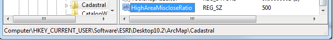
If you’d like to change the ratio limit of 1:5000, you can do this by adding a registry key as follows:
Run regedit.exe (for example by typing it into the entry field after you click the windows Start button)
Navigate to HKEY_CURRENT_USER\Software\ESRI\Desktop10.2\ArcMap\Cadastral
Enter a new string value called “HighAreaMiscloseRatio” and give it a value less than 5000, example 500 (representing 1:500)
-Tim
- Mark as New
- Bookmark
- Subscribe
- Mute
- Subscribe to RSS Feed
- Permalink
- Report Inappropriate Content
The Stated Area field is populated when the parcel has a misclose ratio of better than 1:5000. If the field is empty, like when there’s a new parcel, or if you intentionally remove the string, then the system will compute an area for you and enter the string based on the record values on the lines; it’ll use the plan’s area unit to compute it and will then add the suffix such as “sq.ft”. If the field already has a string value in it then that value is left alone and the value will not be overwritten. The reason for the misclose ratio limit is that since the area is computed based on the record distances and bearings, if there is a large misclose indicating an incorrectly entered record distance or bearing, then the calculated area is also going to be incorrect. The stated field is considered by the fabric to be record information, and so you can overwrite the string and type, for example, “10 Acres” or whatever else is stated on the legal record. As mentioned before, any string found in this field will not be overwritten automatically by the Parcel Editor. If you want the Parcel editor to re-calculate the area, then you need to first remove the string in this field, then make the change to the record value and save the parcel again.
If you’d like to change the ratio limit of 1:5000, you can do this by adding a registry key as follows:
Run regedit.exe (for example by typing it into the entry field after you click the windows Start button)
Navigate to HKEY_CURRENT_USER\Software\ESRI\Desktop10.2\ArcMap\Cadastral
Enter a new string value called “HighAreaMiscloseRatio” and give it a value less than 5000, example 500 (representing 1:500)
-Tim
- Mark as New
- Bookmark
- Subscribe
- Mute
- Subscribe to RSS Feed
- Permalink
- Report Inappropriate Content
Thanks for the info Tim Hodson
After messing around with this some more I noticed that the remainder parcel has a misclose ratio of 1:96 after the remainder task. It was 1:83663 before. The parcel used to perform the remainder has a misclose ratio of 1:100000. When I open the remainder it now has a misclose distance of 30 feet.
I am suspecting I am running into issues with curves, the new parcel joins with the old parcel's boundary at two curves. I did join at all of the shared vertices and the radial points. Am I going to have to rebuild the new tax parcel from scratch to fix it?
Thanks,
Jeff
Summit County, Utah
- Mark as New
- Bookmark
- Subscribe
- Mute
- Subscribe to RSS Feed
- Permalink
- Report Inappropriate Content
Jeff,
This can happen when the parent parcel and the new parcel have different rotations (or scales). I suspect that you may be running into the conundrum/decision of whether to:
- copy the exact record values from the original lines from both parcels when creating the new remainder’s lines, thereby forgoing good misclose or
- recomputing the record values using a consistent scale rotation for the new Remainder parcel
The approach you choose is not really a decision that is made on an edit by edit basis, but rather a general approach, and may be based on how much of a rotation difference there is between the two original parcels, before using the one approach over the other.
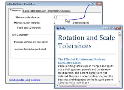
For more specifics, and for info on how to make this choice via a fabric property, please see the documentation that comes with the Add-in called Extended Fabric Properties. After installing the Add-in, start ArcMap or ArcCatalog, right-click the fabric in the Catalog window, then click Extended Fabric Properties. To access the documentation, click the question mark button in the dialog title bar, then click the Minimum rotation tolerance entry field for the information.
-Tim
- Mark as New
- Bookmark
- Subscribe
- Mute
- Subscribe to RSS Feed
- Permalink
- Report Inappropriate Content
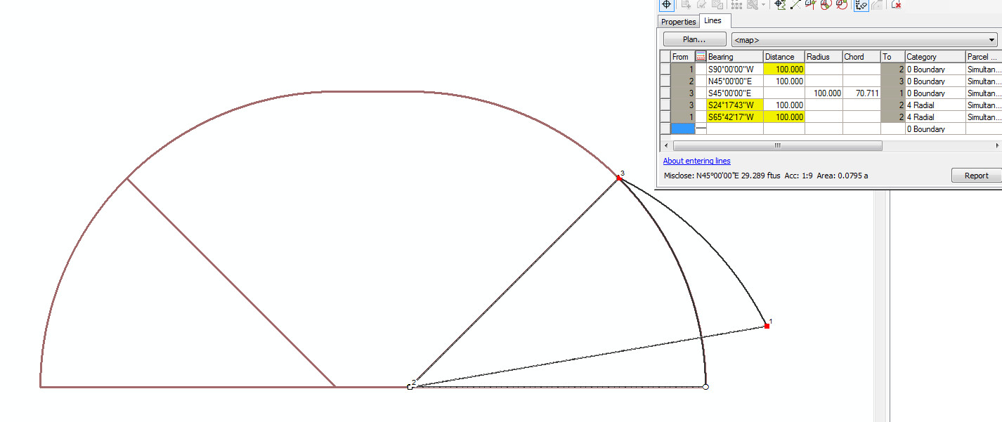
Please forgive me for a long and image laden post.
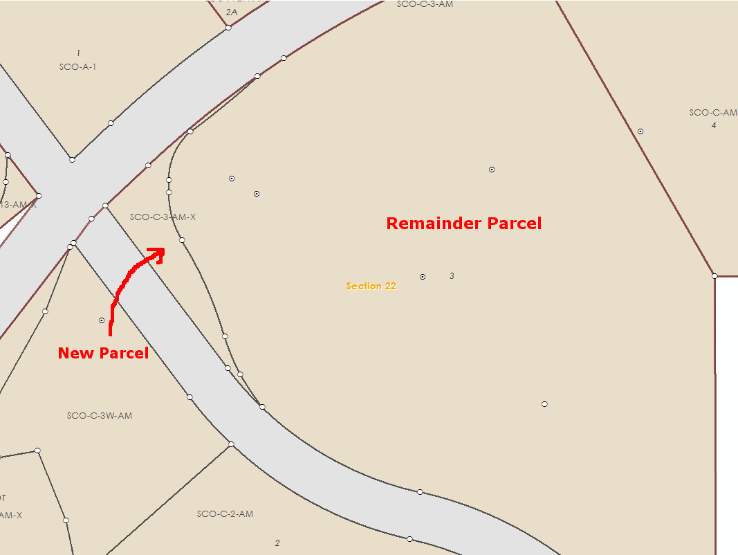
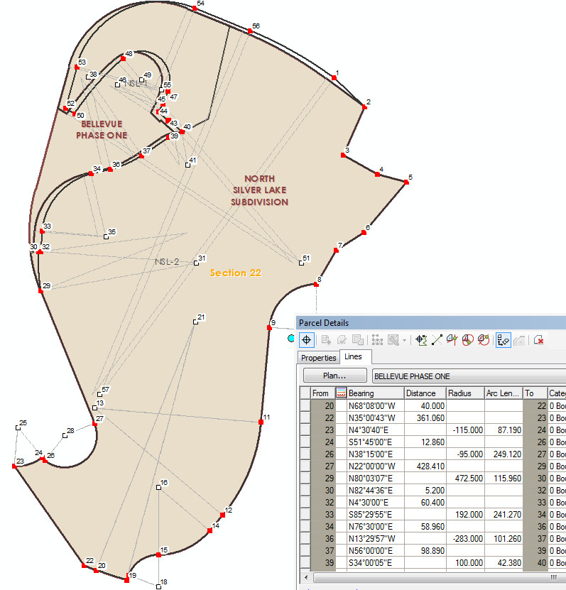
I don't know that this is a rotation/scale issue. I am thinking it is something to do with how the fabric deals with breaking up curves when they are part of a remainder. Here is another case: Part of lot 1 of the North Silver Lake Subdivision is being amended by Bellevue Phase One. Both subdivisions use the same tie point, the lines shared by both subdivisions are identically described. When I join Bellevue to the fabric, the residuals are pretty tight - the highest was around 0.005. The rotation on Bellevue before the remainder is 359.99954°. The rotation for North Silver Lake Sub is 359.99981°. Scales are 1.000006 and 1.000005 respectively. Here is a screen shot of North Silver Lake Sub before the remainder, note the radial bearing for curve 4-6:
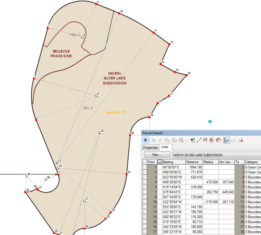
Here is what it looks like after the remainder, notice the radial bearing for curve 29-30 is not the same as the parent curve:
My theory is that the chord bearing from the parent curve is somehow corrupting the new curve. I am willing to bet that point 30 lies along the chord bearing of the parent curve and throwing all of the other lines off.
I just did a simple test that proves my theory. I first created this subdivision -
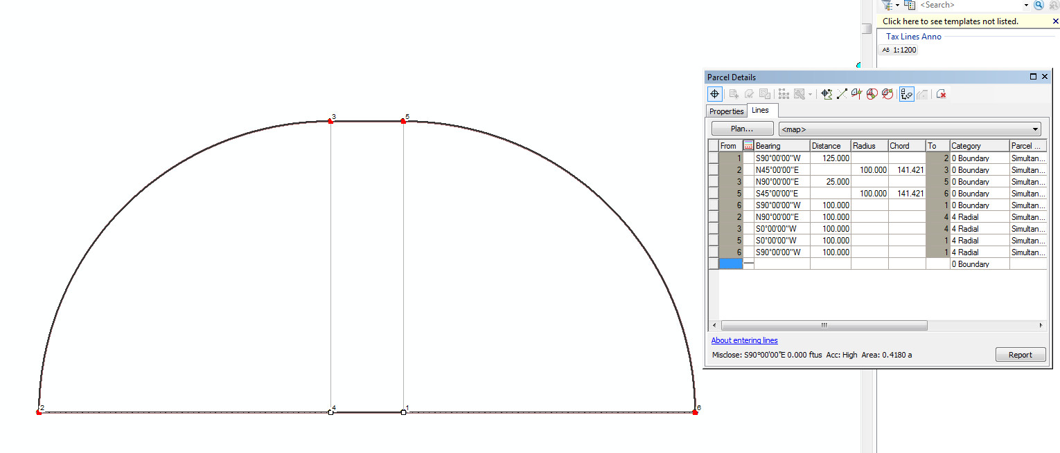
Then this one inside of the parent and joined it.
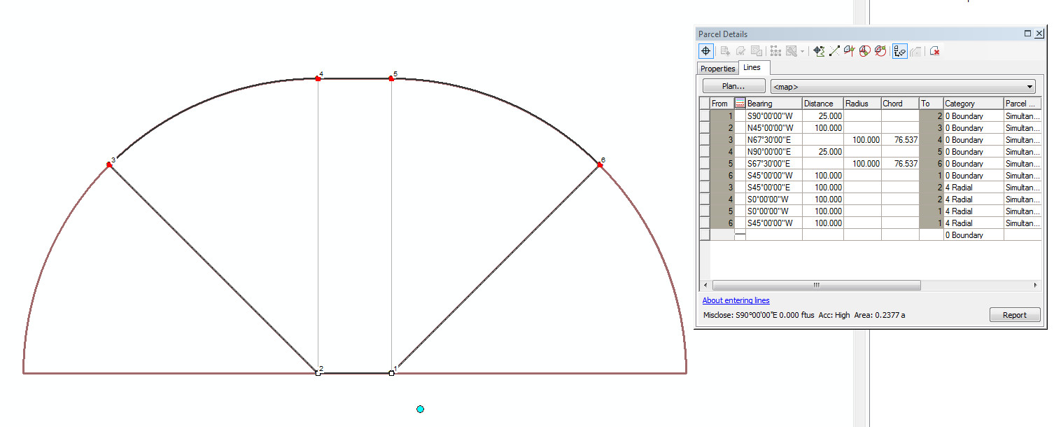
After performing the remainder, I get the following:
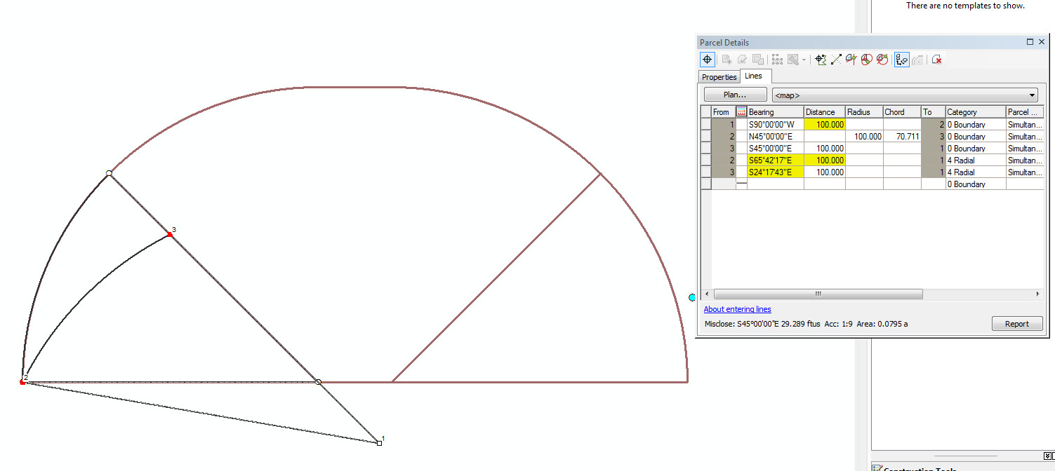
And -
Everything looks fine after the remainder, but no acreage is calculated. You only see the problem after you open the two resulting parcels from the remainder task. Both of those curves are retaining the original chord bearing of the parent parcel instead of being recalculated. Because of the mountainous terrain of our county, splits happen on curves quite frequently (at least 3 times in the past month).
I am thinking this is a bug.
Summit County, Utah
- Mark as New
- Bookmark
- Subscribe
- Mute
- Subscribe to RSS Feed
- Permalink
- Report Inappropriate Content
Jeff,
I have reproduced the scenario you describe. As you demonstrate, the 2 parcels do not have rotations that are significantly different from one another, and so you should not be seeing this effect at all. (It is unrelated to the rotation tolerance I described previously.)
Thank you for reporting this, and for all your work to communicate the problem. Graphics are always appreciated. It will be logged in our system as a bug, and an incident will also be logged with tech support on your behalf. I’ll investigate/research an interim solution.
Thanks again,
-Tim
- Mark as New
- Bookmark
- Subscribe
- Mute
- Subscribe to RSS Feed
- Permalink
- Report Inappropriate Content
Tim,
Thanks for getting that in the system. I had an incident for a previous case, but I didn't describe the problem to the analyst very well, so they couldn't reproduce it. I should have done the simple test case back then.
As far as I can tell it only happens when the new parcel departs from the original on curves.
Thanks,
Jeff
Summit County, Utah
- Mark as New
- Bookmark
- Subscribe
- Mute
- Subscribe to RSS Feed
- Permalink
- Report Inappropriate Content
Jeff -
Would the ideal solution (option) be the inversed geometries as the COGO - and the calculated field on the lines marked to true or parcel marked compiled from records = true?
- Mark as New
- Bookmark
- Subscribe
- Mute
- Subscribe to RSS Feed
- Permalink
- Report Inappropriate Content
Chris,
I have never understood what the Compiled from Records field was and how it impacts the fabric. I asked what the field did a while ago in the old forums and I didn't get much response. I now realize I should have found it here but missed it for some reason. The way I understand it now is if Compiled From Records is True the dimensions for the polygon were calculated by inverting the lines.
I don't want this to happen in this case.
Would it be better to select the original tax parcel and perform a "Construct from Parent" task, marking the original as historic? The only down side I see to this method is the new parcel shares the same plan as the old one, but I can change that in the attributes.
Thanks,
Jeff
Summit County, Utah
- Mark as New
- Bookmark
- Subscribe
- Mute
- Subscribe to RSS Feed
- Permalink
- Report Inappropriate Content
I was using the 'Compiled' field in reference to parcels that may have been generated from the geometry vs. cogo (as you suggested).
Maybe Tim Hodson can dig up some details about how that related to the adjustment.
I'm not sure that construct from parent will help you in this situation either (unless you know what the basis of bearing is and apply that to the parent parcel). And that's assuming that the existing parcel hasn't been adjusted to fit (scaled and rotated as Tim talks about).
My guess is that the "split lines" that you create will also not perfectly close up to the parent lines and will require some "tweaking", extending or trimming. Have you tried this - what was the result?