- Home
- :
- All Communities
- :
- Industries
- :
- Land Records and Valuation
- :
- Land Records and Valuation Questions
- :
- Re: Digitize a curve in the parcel fabric
- Subscribe to RSS Feed
- Mark Topic as New
- Mark Topic as Read
- Float this Topic for Current User
- Bookmark
- Subscribe
- Mute
- Printer Friendly Page
Digitize a curve in the parcel fabric
- Mark as New
- Bookmark
- Subscribe
- Mute
- Subscribe to RSS Feed
- Permalink
- Report Inappropriate Content
I am trying to digitize a curve from a tax map that spits a tax parcel in my parcel fabric. I do not have any curve data for the curve and I have georeferenced the map to the tax parcel layer.
I understand how to split the parcel when I can input cogo information for the courses but I cannot find a way to digitize an arc like I can do using the editor toolbar using the Parcel Editor tools for the parcel fabric.
Has anyone else had this problem and found a solution.
- Mark as New
- Bookmark
- Subscribe
- Mute
- Subscribe to RSS Feed
- Permalink
- Report Inappropriate Content
cogo tools are described in the help files...at least those available to parcel fabric About COGO tools in the parcel fabric—Help | ArcGIS for Desktop
- Mark as New
- Bookmark
- Subscribe
- Mute
- Subscribe to RSS Feed
- Permalink
- Report Inappropriate Content
Neil,
Usually there is enough information on the plat to get the curve in using the data entry grid. Sometimes surveyors forget to label things but other times the information you need is implied. Sometimes the lot lines radiating out from the curve are aligned with the radial line of the curve. Sometimes I have to come around from the other direction that may make the curve tangent. And other times you have to do some math.
Can you post the plat?
Jeff
Summit County, Utah
- Mark as New
- Bookmark
- Subscribe
- Mute
- Subscribe to RSS Feed
- Permalink
- Report Inappropriate Content
Thanks Jeff.
Unfortunately in this case I do not have any curve data to use. I have attached the map.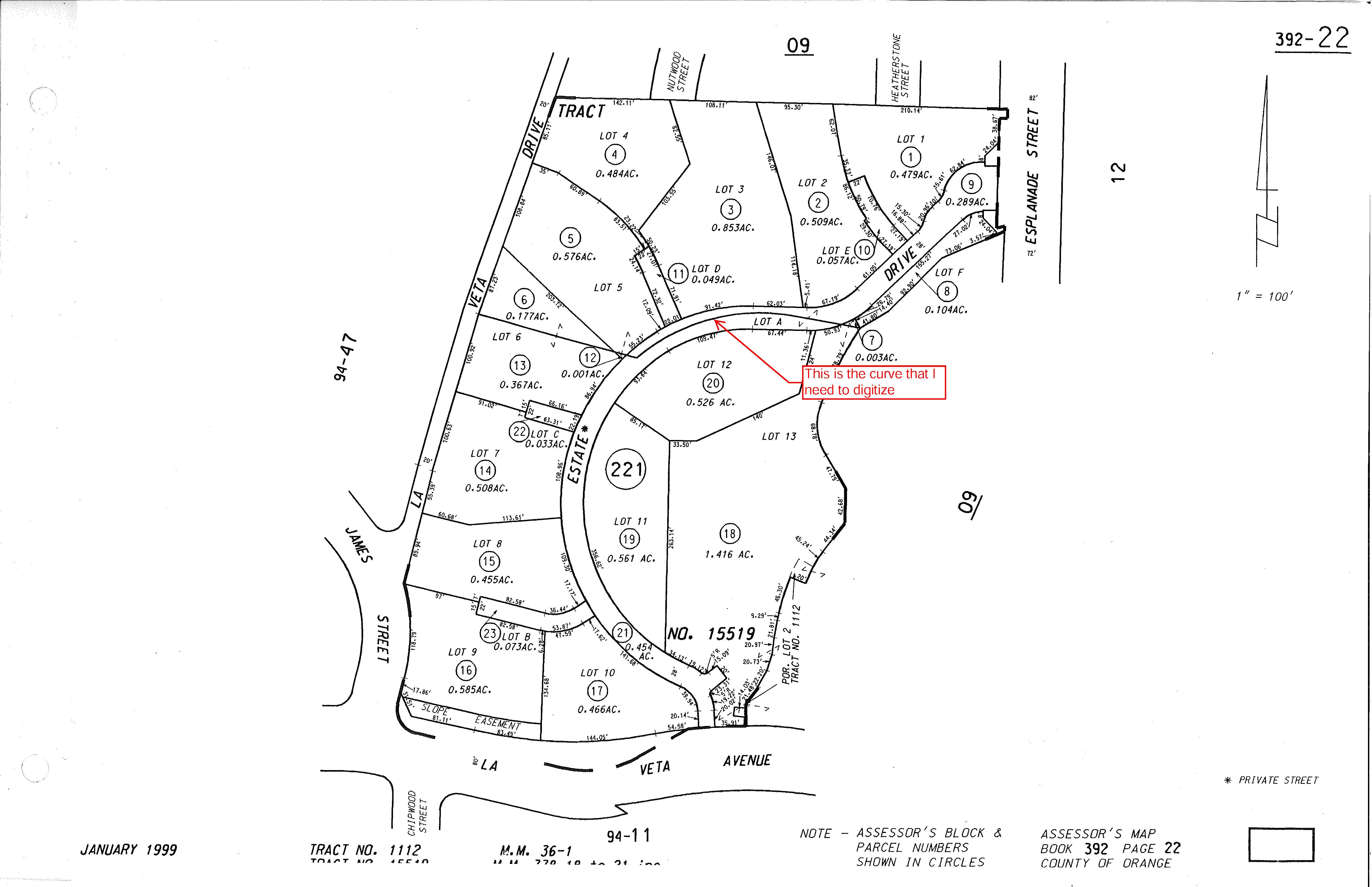
- Mark as New
- Bookmark
- Subscribe
- Mute
- Subscribe to RSS Feed
- Permalink
- Report Inappropriate Content
That looks like it is a tax map not the original plat? If it is something that splits those properties you may be able to find the curve info in a deed? Or if it is an administrative boundary for your assessment purposes you could create a new parcel and right click with the construction tool and make sure the "Digitize Mode" is checked, digitize the lines going into and out of the curve - start near number 7 digitize the line heading west to the point of tangency and then delete the autofilled number in your next line in the grid (probably 2) and digitize the other line starting from the west from La Veta Dr, then you can digitize a line straight across to the endpoint of your first line. That last line would give you your chord bearing and chord length - you would have to start experimenting with radius values until you are satisfied, but it will probably be between the two radii of the right of way curves.
I hope that makes sense.
Summit County, Utah
- Mark as New
- Bookmark
- Subscribe
- Mute
- Subscribe to RSS Feed
- Permalink
- Report Inappropriate Content
Hi Jeff,
Yes that makes sense.
Our parcel layer was digitized 20+ years ago from 100 scale mylar basemaps so the accuracy is not too good. Before I converted our data to the parcel fabric I would georeference a map or plat and digitze the new lot boundary or split lots using the tools on the editor toolbar. This was quick and easy to do and was still accurate enough taking into account how the layer was originally created and how we are using it.
I was hoping that there would still be an option with the parcel editor tools to still be able to edit the parcels in this way when accurate bearing and distances were not available or needed.